Hoeyang County
| Hoeyang County 회양군 | |
|---|---|
| County | |
| Korean transcription(s) | |
| • Chosŏn'gŭl | 회양군 |
| • Hancha | 淮陽郡 |
| • McCune-Reischauer | Hoeyang kun |
| • Revised Romanization | Hoeyang-gun |
 | |
| Country | North Korea |
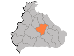
| Province | Kangwon Province |
| Administrative divisions | 1 ŭp, 25 ri |
| Area | |
| • Total | 540 km2 (210 sq mi) |
| Population (1991 est.) | |
| • Total | 100,893 |
Hoeyang County is a kun, or county, in Kangwon province, North Korea. It was established in a general reorganization of local government in 1952.
The county's area is primarily mountainous, with the Taebaek and Kwangju ranges both passing through the county. Two basins, the Hoeyang Basin and Changdo Basin, interrupt the rugged terrain. The highest point is Piryubong on Kumgangsan. The chief local stream is the Pukhan River, which flows south and east into South Korea. The climate is continental, with extremely cold winters.
The chief local industry is agriculture, although the terrain does not permit rice to be cultivated; instead, local crops include barley, wheat, oats, millet, maize, soybeans, and potatoes. Cattle are also raised. The maize-based yŏt candy from the district is widely known. Local mines work to extract the deposits of tungsten, barite, molybdenum, graphite, gold, silver, and lead found in the county.
Hoeyang is served by roads and also by rail, including the Kumgangsan Line electric railroad.
See also
- Geography of North Korea
- Administrative divisions of North Korea
- Kangwon (North Korea)
External links
- (Korean) In Korean language online encyclopedias:
| ||||||||||||||||