Hoboken, Antwerp
| Hoboken | ||
|---|---|---|
| District of Antwerp | ||
|
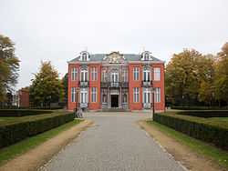
Sorghvliedt Castle (Kasteel Sorghvliedt) | ||
| ||
 | ||
| Coordinates: 51°17′0″N 4°21′0″E / 51.28333°N 4.35000°ECoordinates: 51°17′0″N 4°21′0″E / 51.28333°N 4.35000°E | ||
| Country | Belgium | |
| Region |
| |
| Province |
| |
| Municipality | Antwerp | |
| Area | ||
| • Total | 10.67 km2 (4.12 sq mi) | |
| Highest elevation | 6 m (20 ft) | |
| Lowest elevation | 0 m (0 ft) | |
| Population (2006) | ||
| • Total | 34 443 | |
| • Density | 3,228/km2 (8,360/sq mi) | |
| Source: NIS | ||
| Postal code | 2660 | |
| Area code | 03 | |

Hoboken (Dutch pronunciation: [ˈɦo.bo.kə(n)]) is a southern district of the arrondissement and city of Antwerp, in the Flemish Region of Belgium. It is located at the Scheldt river.
Name
The name Hoboken is derived from Middle Dutch Hooghe Buechen or Hoge Beuken, meaning High or Tall Beeches. To this day there is a hospital in Hoboken named "Hoge Beuken".[1]
A local children's story says that the name "Hoboken" is derived from a little boy who accidentally dropped his sandwich in the Schelde river, which flows near Hoboken. In the local dialect of Dutch, a "boke" is a sandwich and "ho" is a way of shouting "stop", so he must have shouted "Ho, boken!!!".
History
Hoboken boasts an annual 5K beer server race. The tradition started, according to legend, in 1777, with the proclamation of the United States of Belgium (Dutch: Verenigde Nederlandse Staten or Verenigde Belgische Staten, French: États-Belgiques-Unis). The race is held annually on the first Sunday of November and is often amalgamated by the All Saints Day celebration.
References
- ↑ "Onze ziekenhuizen" (in Dutch). Zna.be. Retrieved 2014-03-16.
External links
| Wikimedia Commons has media related to Hoboken (Antwerp). |
| ||||||||