Hkakabo Razi
| Hkakabo Razi | |
|---|---|
| ခါကာဘိုရာဇီ | |
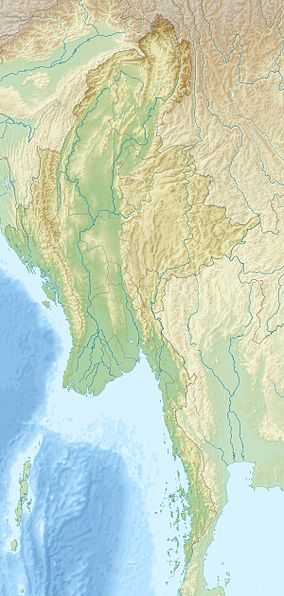 Hkakabo Razi Location in Myanmar (on the border tri-point with China and India) | |
| Elevation | 5,881 m (19,295 ft)[1] |
| Listing | Country high point |
| Location | |
| Location |
Kachin, Myanmar Xizang, China Arunachal Pradesh, India |
| Range | Himalaya |
| Coordinates | 28°19′59″N 97°28′00″E / 28.33306°N 97.46667°ECoordinates: 28°19′59″N 97°28′00″E / 28.33306°N 97.46667°E |
| Climbing | |
| First ascent | 15 September 1996 |
| Easiest route | snow/ice climb |
Hkakabo Razi (Burmese: ခါကာဘိုရာဇီ, pronounced: [kʰàkàbò ɹàzì]; simplified Chinese: 开加博峰; traditional Chinese: 開加博峰; pinyin: Kāijiābó Fēng) is Burma's highest mountain, and the highest mountain in South East Asia, located in the northern Myanmar state of Kachin. It lies in an outlying subrange of the Greater Himalayan mountain system. With its height 5,881 m (19,295 ft), Hkakabo Razi is higher than the highest mountains of Europe and Australia.[2][3] The mountain lies on the border tri-point among Myanmar, China, and India.
The peak is enclosed within Hkakabo Razi National Park. The park is entirely mountainous and is characterized by broad-leaved evergreen rain forest, a sub-tropical temperate zone from 8,000 to 9,000 feet (2,400–2,700 m), then broad-leaved, semi-deciduous forest and finally needle-leaved evergreen, snow forest. Above 11,000 feet (3,400 m), the highest forest zone is alpine, different not only in kind from the forest, but different in history and origin. Still higher up, around 15,000 feet (4,600 m), cold, barren, windswept terrain and permanent snow and glaciers dominate. At around 17,500 feet (5,300 m), there is a large ice cap with several outlet glaciers.
Environmental protection
Hkakabo Razi was established as a natural reserve on January 30, 1996 and as a national park on November 10, 1998. The Khakaborazi National Park is the last stronghold for biodiversity in Myanmar. Extraordinarily rich flora and fauna, ranging from lowland tropical to alpine species still await proper research and identification. They have barely been studied, and the park remains an excellent center for field study for students of botany, geology, zoology and geography.
A study was done by the Forest Department with the assistance of Wildlife Conservation Society of New York during 1997 and 1998. The results have been presented in ICIMOD sponsored Workshop “Sub-regional Consultation on Conservation of Hkakabo Razi Mountain Ecosystems in Eastern Himalayas”, held in Putao, Myanmar during 25–29 October 1999. This was followed in 2001 with an international, interdisciplinary team of scientists from the California Academy of Sciences in San Francisco, National Geographic Society, Harvard University, the Chinese Academy of Sciences, and the Myanmar Forestry Ministry. On 11 September 2001, herpetologist Joseph Slowinski, team leader from California Academy of Sciences, was bitten by a venomous krait and died in the field.
In 2002-2003, P. Christiaan Klieger, anthropologist from California Academy of Sciences and photographer Dong Lin retraced their previous steps, and succeeded in making the first anthropological survey of the Hkakabo Razi region. On foot they reached the northern-most village in Myanmar, Tahaundam, which is inhabited by about 200 Khampa Tibetans, including mountaineer Nyama Gyaltsen (see below).[4]
The region will shortly be opened to the general public through eco-tourism by the Myanmar authorities. The government is collecting information for development in that regard and a number of scientific expeditions have been already accepted in the region.
Only a few Westerners ever made it to Mt. Hkakabo Razi, the National Park or anywhere close to it. Captain B.E.A. Pritchard was the first Westerner to visit the Alun Dung valley, in 1913.[5]
Climbing information
Takashi Ozaki (Japan, 1951-May 14, 2011) and Nyima Gyaltsen (aka "Aung Tse"; Burma) made the first ascent in 1996. Ozaki had attempted the mountain in 1995 but was turned back due to bad weather. Ozaki died May 14, 2011 while attempting to summit Mt. Everest. The route to basecamp is long (four weeks) and arduous through dense rain forest with many unbridged stream crossings. The recent first ascent can also be attributed to the policy that foreigners were not allowed into the area until 1993.
In 2013, the nearby peak of Gamlang Razi was climbed and measured at 5,870 meters (19,259 ft) using an advanced version of GPS, making it possibly the highest in Myanmar. The Ozaki expedition had been unable to measure the exact height of Hkakabo Razi, so in November 2014, an expedition set out to measure it using the same equipment as the Gamlang Razi team. The 2014 group was led by Hilaree O'Neill, and also included Mark Jenkins, Cory Richards, Renan Ozturk, Emily Harrington, and Taylor Rees. On November 7, 2014, Jenkins, Richards, and Ozturk made the final attempt at the summit but were forced to turn back at 5,742 meters (18,840 ft). They estimated that the summit lay an additional 243 meters (800 feet) higher.[6]
See also
- List of mountains in Burma
- List of Southeast Asian mountains
- Khakaborazi National Park
- Gamlang Razi
References
- ↑ "Hkakabo Razi, Myanmar/China" on Peakbagger.com Retrieved 28 September 2011
- ↑ The Columbia Encyclopedia, Sixth Edition
- ↑ Hkakabo Razi summary
- ↑ Klieger, P. Christiaan (2006). "A Tale of the Tibeto-Burman 'Pygmies'". In P. Christiaan Klieger. Proceedings of the Tenth Seminar of the IATS, 2003, Volume 2 Tibetan Borderlands. Leiden: Brill Academic Press. ISBN 978-90-04-15482-7.
- ↑ http://www.jstor.org/stable/1784147?seq=3
- ↑ http://news-beta.nationalgeographic.com/2015/01/150116-burma-climb-myanmar-hkakabo-razi/