Hizma
| Hizma | |
|---|---|
| Other transcription(s) | |
| • Arabic | حزما |
| • Also spelled | Hizme (official) |
|
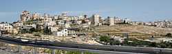
Hizma | |
 Hizma Location of Hizma within Palestine | |
| Coordinates: 31°50′06″N 35°15′43″E / 31.83500°N 35.26194°ECoordinates: 31°50′06″N 35°15′43″E / 31.83500°N 35.26194°E | |
| Palestine grid | 175/138 |
| Governorate | Jerusalem |
| Government | |
| • Type | Municipality |
| Area | |
| • Jurisdiction | 4,563 dunams (4.6 km2 or 1.8 sq mi) |
| Population (2006) | |
| • Jurisdiction | 5,700 |
| Name meaning | The bundle[1] |
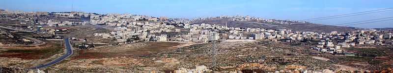
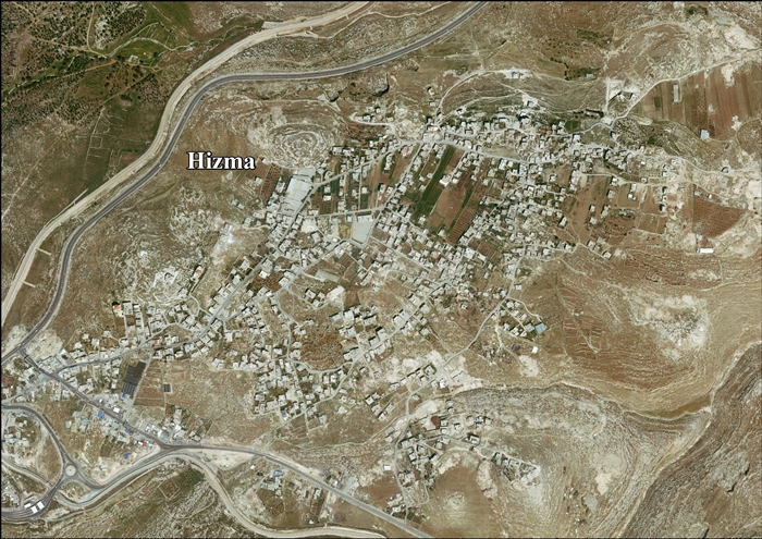
Hizma (Arabic: حزما; Hebrew: חיזמה) is a Palestinian town in the Jerusalem Governorate, seven kilometer from Jerusalem's Old City. The town, located in Area B, borders the Israeli settlements Neve Yaakov, Pisgat Ze'ev, Geva Binyamin and Almon. A small eastern neighbourhood of Hizma is called Hizmah.[2] Since 1967, Hizma is occupied by Israel. The village is cut off from Jerusalem by the Separation Wall in the west, which is built in 2005 on confiscated Palestinian land. As of 2007, Hizma had a population of about 5650 residents.[3] Hizma is cut off from the West Bank by a chain of Israeli settlements in the east.
History
Albright and others identified Hizma with the biblical town of Azmaveth of the tribe of Benjamin.[4] However, Gibson more recently questioned this identification, citing the lack of archaeological remains from the necessary time period.[5] Towards the end of the Second Temple period, there was an industry here making fine stoneware from the local limestone.[6] Products included vases and bowls turned on a lathe, and mugs carved by hand.[6] Examples of stoneware that may have originated here have been found in many places in the Jerusalem region, mostly dating from the first and second centuries CE.[6]
Ottoman era
In 1517, the village was included in the Ottoman empire with the rest of Palestine, and in the 1596 tax-records it appeared as Hamza, located in the Nahiya of Jabal Quds of the Liwa of Al-Quds. The population was 28 households, all Muslim. They paid a tax rate of 33,3% on agricultural products, which included wheat, barley, vineyards and fruit trees, occasional revenues, goats and beehives; a total of 2800 Akçe.[7][8]
In 1832, Edward Robinson found the village had been deserted for two months, as the villagers had "fled across the Jordan" to escape conscription.[9] In 1863 Victor Guérin found the village to have 200 inhabitants. He further noted that some of the houses, particularly the lower part, seemed to be built from ancient materials, and some cisterns also looked ancient.[10]
An Ottoman village list of about 1870 showed 51 houses and a population of 150, though the population count included only the men.[11] In 1883, the Palestine Exploration Fund's Survey of Western Palestine (SWP) described Hizma as a "small stone village, standing high on a prominent hill, the slopes of which are covered with olives. It has a well to the west."[12]
British Mandate era
In the 1922 census of Palestine, conducted by the British Mandate authorities, Hizma had a population of 515, all Muslims,[13] increasing slightly in the 1931 census to 521, still all Muslim, in 91 inhabited houses.[14]
In 1945 the population of Hizma was 750, all Arabs, and the total land area was 10,438 dunams of land according to an official land and population survey.[15] Of this, 200 dunams were plantations and irrigable land, 2,338 for cereals,[16] while 45 dunams were built-up (urban) land.[17]
1948-1967
In the wake of the 1948 Arab–Israeli War, and after the 1949 Armistice Agreements, Hizma came under Jordanian rule.
1967-present
After the Six-Day War in 1967 Hizma has been under Israeli occupation.

Under the Oslo II Accord, about 9% of the village area was assigned as Area B; the remaining 91% became Area C. Israel has confiscated thousands of dunums of Hizma's land for construction of settlements, bypass roads and the Israeli West Bank barrier. 19% of the village's total area was used to establish Neve Ya'akov, Pisgat Ze'ev and Pisgat Amir.[3]
West Bank barrier
The Wall, built in 2005 on confiscated Palestinian land, has isolated from the village some 40% of its land. Some of Hizma's Palestinian residents live on the Jerusalem side of the Barrier. An Israeli checkpoint is located on the Jerusalem municipal boundary at an opening in the Separation Wall. Only Palestinians holding Jerusalem IDs and settlers may access it without a special permit. Residents with a Palestinian ID are denied access to the City. Pisgat Ze'ev lies on the Jerusalem side of the checkpoint, while the town of Hizma lies on the West Bank side.[3]
Economy
In 2010, more than half of the workforce was working in the government or private employees sector; 22% depended on the Israeli labor market, 14% on agriculture, and 7% worked in the trade sector.
Hizma village is known for the cultivation of olives; 112 dunums of land were cultivated with olive trees in 2010. Cereals were grown on 233 dunums.[3]
References
- ↑ Palmer, 1881, p. 295
- ↑ Where is Hizmah in Palestine Located?
- ↑ 3.0 3.1 3.2 3.3 Hizma Village Profile. Applied Research Institute - Jerusalem, August 2012. On Jerusalem → community data
- ↑ Albright (1922/3), pp. 156–157.
- ↑ Gibson (1983), p. 176
- ↑ 6.0 6.1 6.2 Gibson (1983), passim.
- ↑ Hütteroth and Abdulfattah, 1977, p. 119
- ↑ Toledano, 1984, p. 293, gives the location of Hizma as 35°15′40″E 31°50′15″N
- ↑ Robinson and Smith, 1841, vol 2, pp. 111-112
- ↑ Guérin, 1869, pp. 74-75
- ↑ Socin, 1879, p. 155
- ↑ Conder and Kitchener, 1883, SWP III; p. 9
- ↑ Barron, 1923, Table VII, Sub-district of Jerusalem, p. 14
- ↑ Mills, 1932, p. 39
- ↑ Government of Palestine, Department of Statistics. Village Statistics, April, 1945. Quoted in Hadawi, 1970, p. 57
- ↑ Government of Palestine, Department of Statistics. Village Statistics, April, 1945. Quoted in Hadawi, 1970, p. 102
- ↑ Government of Palestine, Department of Statistics. Village Statistics, April, 1945. Quoted in Hadawi, 1970, p. 152
Bibliography
| Wikimedia Commons has media related to Hizma. |
- Albright, W. F. (1922–1923). "Excavations And Results At Tell El-Fûl (Gibeah Of Saul)". American Schools of Oriental Research, Annual (4).
- Barron, J. B., ed. (1923). Palestine: Report and General Abstracts of the Census of 1922. Government of Palestine.
- Conder, Claude Reignier; Kitchener, Herbert H. (1883). The Survey of Western Palestine: Memoirs of the Topography, Orography, Hydrography, and Archaeology 3. London: Committee of the Palestine Exploration Fund.
- Dauphin, Claudine (1998). La Palestine byzantine, Peuplement et Populations. BAR International Series 726 (in French). III : Catalogue. Oxford: Archeopress. (pp. 891-2)
- Gibson, Shimon (1983). "The Stone Vessel Industry at Ḥizma". Israel Exploration Journal 33 (3/4): 176–188.
- Guérin, Victor (1869). Description Géographique Historique et Archéologique de la Palestine (in French). 1: Judee, pt. 3. Paris: L'Imprimerie Nationale.
- Hadawi, Sami (1970). Village Statistics of 1945: A Classification of Land and Area ownership in Palestine. Palestine Liberation Organization Research Center.
- Hütteroth, Wolf-Dieter; Abdulfattah, Kamal (1977). Historical Geography of Palestine, Transjordan and Southern Syria in the Late 16th Century. Erlanger Geographische Arbeiten, Sonderband 5. Erlangen, Germany: Vorstand der Fränkischen Geographischen Gesellschaft. ISBN 3-920405-41-2.
- Mills, E., ed. (1932). Census of Palestine 1931. Population of Villages, Towns and Administrative Areas. Jerusalem: Government of Palestine.
- Palmer, E. H. (1881). The Survey of Western Palestine: Arabic and English Name Lists Collected During the Survey by Lieutenants Conder and Kitchener, R. E. Transliterated and Explained by E.H. Palmer. Committee of the Palestine Exploration Fund.
- Robinson, Edward; Smith, Eli (1841). Biblical Researches in Palestine, Mount Sinai and Arabia Petraea: A Journal of Travels in the year 1838 2. Boston: Crocker & Brewster.
- Socin, A. (1879). "Alphabetisches Verzeichniss von Ortschaften des Paschalik Jerusalem". Zeitschrift des Deutschen Palästina-Vereins 2: 135–163.
- Toledano, E. (1984). "The Sanjaq of Jerusalem in the Sixteenth Century: Aspects of Topography and Population". Archivum Ottomanicum 9: 279–319.
External links
- Welcome To Hizma
- Survey of Western Palestine, Map 17: IAA, Wikimedia commons
- Hizma Village (Fact Sheet)
- Hizma Village Profile. Applied Research Institute - Jerusalem, August 2012.
- Himza areal photo
| ||||||||||||||||||||
