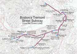
History of the MBTA Green Line

The name "Green Line" was assigned in the 1960s as part of a major reorganization of the MBTA system's branding.
The predecessor of today's Green Line was created by the Massachusetts legislature, but under private ownership, as the West End Street Railway in 1887. This system of horse-drawn streetcars was the merger of numerous independently operated railways built from the 1850s onward. At the time of the merger, West End operated 1,480 cars with a team of 7,816 horses.[1]
The Allston - Park Square line (which served the general area of the "A" Branch, and is covered in that article) was the first section to be converted to electric traction in 1889, using modified existing horsecars outfitted with Frank J. Sprague's equipment first demonstrated in Richmond, Virginia. This initial line used overhead trolley wires for most of its length, but also third rail equipment supplied by the Bentley-Knight Electric Railway Company in sections where residents initially objected to overhead lines. The Bentley-Knight approach was abandoned soon after several horses were electrocuted due to inadequate insulation.[2] By 1889, the Sprague equipment was dropped in favor of Thomson-Houston (now General Electric) motors and generators, to which the rest of the system was converted.
In 1897, the West End Street Railway property was handed over to the Boston Elevated Railway (BERy) in the form of a 24-year lease, and the companies were ultimately combined. BERy, now under state ownership, evolved into today's MBTA, which was called the Metropolitan Transit Authority (MTA) in the interim from 1947 to 1964.
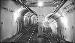
As a tunnel built to get streetcar lines off the streets, rather than a rapid transit line, the Tremont Street Subway has had many connecting surface branches, with many services operating in many patterns. Additionally, many services from other companies, notably the Eastern Massachusetts Street Railway and its predecessors, have run into the subway from outer suburban points via BERy trackage. A partial list of these services is in the green rows on Boston-area streetcar lines.
In the 1970s the Green Line and all other MBTA lines were re-evaluated by the Boston Transportation Planning Review for region-wide efficacy and future modernization alternatives initiated as far as physical plant and operating measures.
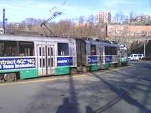
Portals
Cars entered the subway from the surface at a number of portals or inclines, listed here from north to south/east to west.
Lechmere
Lechmere is the north end of the Green Line. From the opening of the Lechmere Viaduct leading to it in 1912 until 1922, streetcar lines simply fed onto the viaduct from Cambridge Street and Bridge Street (now Monsignor O'Brien Highway). In 1922 a prepayment station was opened, with a new loop for subway trains to turn around and a separate loop for surface cars, and no intermingling between the two. The surface lines have since been replaced with buses, but the Green Line still turns around at Lechmere.
Canal Street

The Canal Street Portal (also Haymarket Portal, North Station Portal or Causeway Street Portal, often referred to in revenue service as the Canal Street Loop) was part of the transition between subway and elevated railway on the Green Line, as it transitioned from the Tremont Street Subway to the Causeway Street Elevated towards the Lechmere Viaduct until 2004, when the Green Line north of North Station was closed for building of a new tunnel and portal. Certain trains turned at Canal Street, while others emerged from the subway to a viaduct to Lechmere. It was, however, possible for a passenger to alight from a train at Canal Street and proceed up a series of stairways to the Lechmere Viaduct. However most passengers desiring to continue to Science Park or Lechmere would have changed to a Lechmere signed car from a North Station signed car prior to the emergence from the central subway.
The original four-track portal opened in 1898 at the north end of the first subway; cars could turn east or west on Causeway Street. In 1901 the Charlestown Elevated was connected to the outer tracks, and streetcars only operated via the inner tracks. The Washington Street Tunnel opened in 1908, connecting to the Elevated via a new portal just east of the streetcar one, and all four tracks were once again open for streetcar use until 1975. In 1912 the Lechmere Viaduct opened, again using the two outer tracks for an elevated line. The inner tracks continued to serve the surface, including a surface station at North Station, until 1997, when they were closed for construction of the new tunnel and the Green Line was shifted to the old Orange Line (Charlestown Elevated) portal along the way. The 93 was the last service to continue onto surface streets from the portal, last running in 1949.
Pleasant Street
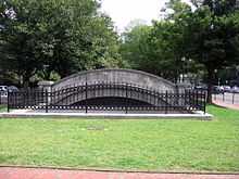
The Pleasant Street Portal was the south end of the Tremont Street Subway, opened one month after the original subway in 1897. It split from the Boylston Street Subway at a flying junction at Boylston, and another flying junction split the tunnel into two side-by-side tunnels to the four-track portal. The two west tracks rose onto Tremont Street and the two east ones onto Pleasant Street, later part of Broadway. From 1901 to 1908 the portal was only used by Washington Street Elevated trains, after which streetcar service was restored—though much of it had been cut back to Dudley for transfer to the Elevated. Until 1953 service ran to City Point at eastern end of South Boston as part of 9. The last cars ran through the portal in 1961 as part of the 43, and in 1962 a shuttle service from Boylston to the portal was ended. The portal has since been covered.
Public Garden and Boylston Street
The first portal to open, on September 1, 1897, was the Public Garden Portal, providing an outlet for the subway on the north side of Boylston Street in the Public Garden. When the Boylston Street Subway opened in 1914, extending the subway west, the incline and portal were relocated to the center of Boylston Street as the Boylston Street Portal. The last cars to use the portal ran in 1941 from Huntington Avenue, when the Huntington Avenue Subway opened as a branch off the main subway and the portal was closed.
Northeastern
The Northeastern Portal lies in the median of Huntington Avenue at the end of the Huntington Avenue Subway, just east of Northeastern University. It opened in 1941 and carries "E" Branch trains.
The incline was built as a wooden trestle to the street atop a level grade, as the original plans called for eventual extension of the subway; in the mid 1980s the trestle was replaced with fill (which greatly quieted the sound).
Kenmore
The Kenmore Portal or Kenmore Square Portal opened in 1914 with the extension of the Boylston Street Subway westward to the east side of Kenmore Square, in the median of Commonwealth Avenue. It closed in 1932 when the subway station at Kenmore was built and two new portals were opened to the west.
Blandford Street, St. Marys Street, and Fenway
The Blandford Street Portal and St. Marys Street Portal, in the medians of Commonwealth Avenue and Beacon Street respectively, opened in 1932 as part of the extension of the Boylston Street Subway under Kenmore Square and the opening of the new Kenmore station. They are currently used by the "B" and "C" Branches respectively. The Fenway Portal opened in 1959 along with the opening of the Highland Branch, and provides a third exit from Kenmore, south of the St. Marys Street Portal. It carries trains of the "D" Branch.
Turnarounds
Cars can reverse direction at a number of stations
Lechmere is currently the north end of the Green Line, and consists of a balloon-shaped turnaround.
At North Station, trains heading eastbound/outbound toward Lechmere can turn around. No turnaround is available in the westbound/inbound direction.
At Government Center, trains entering from either the east or west can turn around.
At Park Street trains can turn around in one direction only. Trains headed toward Lechmere upon entering Park Street on the inside track can turn around on a tight turn and end up on the so-called fence track. This is the track that takes trains out to Boston College and Heath Street.
Kenmore is where trains coming from Cleveland Circle or the Riverside Branch can turn around to the outbound track that takes trains to Cleveland Circle or Riverside. No turnaround is available for the "Boston College"/"Commonwealth Avenue" Branch.
Branches
The branches were given letters in 1967, two years after the green color was assigned to the line on August 26, 1965. The letters were assigned increasing from north to south, to the five remaining branches. No branches had used the Canal Street Portal except as a terminal since 1949 with the 93 or the Pleasant Street Portal since 1961 with the 43, and a shuttle until 1962. All trains stop at Government Center, Park Street, Boylston, Arlington, and Copley. All trains except "E" also stop at Hynes Convention Center and Kenmore. Only "E" trains stop at Prudential and Symphony. On the eastern end, only "C" and "E" trains go past Government Center to Haymarket and North Station; the only train that services Science Park and Lechmere is the "E" train. A red line through the letter on a sign means that the train goes only part way on that branch (for example, a D-line car only going as far as Reservoir).
The "B", "Boston College" or "Commonwealth Avenue" Branch is the northernmost of the three lines that split west of Kenmore. It travels west down the middle of Commonwealth Avenue, ending at Boston College. As of February 2009, regular B service turns around at Government Center. It is the most criticized line in the Green Line, primarily due to its high frequency of densely located stops. This causes the branch to bear the highest average per-mile operations cost, the slowest passenger riding time, and the greatest number of complaints.
The "C", "Cleveland Circle" or "Beacon Street" Branch is the middle one of the three branches heading west from Kenmore, and the straightest, running down the middle of Beacon Street through Brookline to Cleveland Circle. As of February 2009, regular "C" service turns around at North Station.
The "D" or "Highland" Branch is the southernmost of the three lines that separate west of Kenmore. It is the longest branch, ending in Newton at Riverside. It is the most recent branch, opening in 1959 along the former right-of-way of the Highland Branch of the Boston and Albany Railroad, and has full grade separation, entering the subway at the Fenway Portal. As of February 2009, regular "D" service turns around at Government Center.
The "E" or "Heath Street" (formerly "Arborway") Branch diverges from the other three lines just west of Copley. It travels mainly on the surface of Huntington Avenue, emerging from the Huntington Avenue Subway at the Northeastern Portal. Since 1985, service has been truncated to Heath Street, with continuing service to Arborway provided by the 39 bus. In 2008, the tracks from Heath Street to Arborway were paved over. The "E" is the only branch to have a regularly used street-running section. As of February 2009, regular "E" service turns around at Lechmere. Passengers must board "E" Branch trains to get to station stops between Lechmere and North Station.[3]
Former branches
The Green Line "A" Branch was the northernmost of the branches, running from the Blandford Street Portal (still used by the "B" Branch), west to Watertown, mostly street-running. The 57 bus replaced the streetcar line in 1969.
The Pleasant Street Portal hosted two services in its final days. The 9 to City Point ended in 1953, and the 43 to Egleston was cut back to Lenox Street in 1956, cut back to the portal in 1961, and ended operation in 1962. Prior to that, the 48 ran out Tremont Street to [Dover Street and Washington Street, ending at Dudley, and last running in 1938.
The last two routes to continue beyond the Canal Street Portal both ran to Sullivan. The 92 ran via Main Street, last running in 1948, and the 93 via Bunker Hill Street last ran in 1949. Until 1997 trains continued to use the portal and its North Station surface station as a terminal.
In addition to the lines that later became the "E" Branch, the predecessors to the 58 and 60 split in Brookline, one branch running into the current "E" tracks and into the Boylston Street Portal, and the other running up Brookline Street to end at Massachusetts Avenue station. These were truncated in 1932 into a shorter route from Brookline Village to the subway via the Boylston Street Portal, which itself stopped running in 1938 (being cut back to Brigham Circle short-turn trips), three years before the closure of that portal.
The last "foreign" cars to operate in the subway were those of the Eastern Massachusetts Street Railway, running from the Canal Street Portal to the Brattle Loop at Scollay Square until 1935. It was then that the old Mystic River Bridge to Chelsea was closed to streetcars and the lines were replaced by bus service; the next year the BERy bought the Eastern Mass Chelsea Division and through-routed it with its lines connecting to the East Boston Tunnel at Maverick.
From the Lechmere terminal opening on July 10, 1922 to February 6, 1931, special service ran from Lechmere to various points on the subway. These trips were replaced on February 7, 1931 by extensions of the various branches from the west, which had terminated at Park Street, through to Lechmere.
See also
- Boston Street Railway Association — historical organization
Notes
| ||||||||||||||||||||||||||||||||||||||||||||||||||||||||||