Hirakawa, Aomori
| Hirakawa 平川市 | |||
|---|---|---|---|
| City | |||
| |||
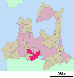 Location of Hirakawa in Aomori Prefecture | |||
 Hirakawa
| |||
| Coordinates: 40°35′N 140°34′E / 40.583°N 140.567°ECoordinates: 40°35′N 140°34′E / 40.583°N 140.567°E | |||
| Country | Japan | ||
| Region | Tōhoku | ||
| Prefecture | Aomori Prefecture | ||
| Area | |||
| • Total | 345.81 km2 (133.52 sq mi) | ||
| Population (April 2012) | |||
| • Total | 33,328 | ||
| • Density | 96.4/km2 (250/sq mi) | ||
| Time zone | Japan Standard Time (UTC+9) | ||
| - Tree | Japanese black pine (Pinus thunbergii) | ||
| - Flower | Indian lotus (Nelumbo nucifera) | ||
| - Bird | Oriental turtle dove (Streptopelia orientalis) | ||
| Phone number | 0172-44-1111 | ||
| Address | 25-6 Kashiwagichō Fujiwara, Hirakawa-shi, Aomori-ken 036-0104 | ||
| Website |
www | ||


Hirakawa (平川市 Hirakawa-shi) is a city located in south-central Aomori Prefecture, Japan.
As of April 2012, the city has an estimated population of 33,328 and a population density of 96.4 persons per km2. The total area is 345.81 km2.
Geography
Hirakawa is located in the mountains and hills to be northwest of Lake Towada. The city has a cold maritime climate characterized by cool summers and cold winters with very heavy snowfall.
Neighbouring municipalities
- Aomori Prefecture
- Akita Prefecture
History
The area around Hirakawa was part of the Hirosaki Domain of the Tsugaru clan during the Edo period. After the Meiji Restoration, it became part of Minamitsugaru District.
The modern city of Hirakawa was established on January 1, 2006, from the merger of the towns of Hiraka and Onoe, and the village of Ikarigaseki (all from Minamitsugaru District).
Local attractions
Transportation
Railway
Highway
External links
| Wikimedia Commons has media related to Hirakawa, Aomori. |
- Hirakawa City official website (Japanese)
| ||||||||||||||||||||||||||||||||||||||||