Hillsdale, Kansas
| Hillsdale, Kansas | |
|---|---|
| census-designated place | |
 Hillsdale, Kansas | |
| Coordinates: 38°39′35″N 94°51′01″W / 38.65972°N 94.85028°WCoordinates: 38°39′35″N 94°51′01″W / 38.65972°N 94.85028°W | |
| Country | United States |
| State | Kansas |
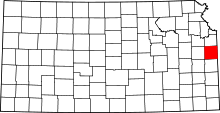
| County | Miami |
| Elevation | 889 ft (271 m) |
| Time zone | Central (CST) (UTC-6) |
| • Summer (DST) | CDT (UTC-5) |
| ZIP code | 66036 |
| Area code(s) | 913 |
| GNIS feature ID | 479414[1] |
Hillsdale is an unincorporated community and census-designated place in Miami County, Kansas, United States. Hillsdale is located near U.S. Route 169 and K-7 6 miles (9.7 km) north-northeast of Paola. Hillsdale has a post office with ZIP code 66036. [2]
History
Hillsdale (originally called Columbia) was laid out in 1869 when the railroad was extended to that point.[3]
The first post office in Columbia, established in August 1868, was renamed Hillsdale in April 1870.[4]
See also
References
- ↑ "US Board on Geographic Names". United States Geological Survey. 2007-10-25. Retrieved 2008-01-31.
- ↑ ZIP Code Lookup
- ↑ Blackmar, Frank Wilson (1912). Kansas: A Cyclopedia of State History, Embracing Events, Institutions, Industries, Counties, Cities, Towns, Prominent Persons, Etc. Standard Publishing Company. p. 845.
- ↑ "Kansas Post Offices, 1828-1961 (archived)". Kansas Historical Society. Retrieved 15 June 2014.
External links
- USD 368, local school district
| |||||||||||||||||||||||||