High Atlas
| High Atlas | |
|---|---|
|
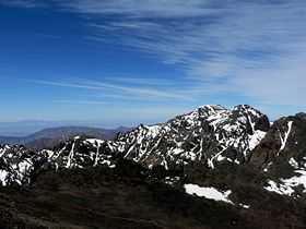
Jbel Toubkal in Toubkal National Park | |
| Highest point | |
| Peak | Jbel Toubkal |
| Elevation | 4,167 m (13,671 ft) |
| Coordinates | 31°03′43″N 7°54′58″W / 31.06194°N 7.91611°W |
| Geography | |
|
<div style="padding:2px 2px 5px 2px;>  Location of the Atlas Mountains across North Africa | |
| Country | Morocco |
| Range coordinates | 31°26′N 6°56′W / 31.43°N 6.93°WCoordinates: 31°26′N 6°56′W / 31.43°N 6.93°W |
| Parent range | Atlas Mountain System |

High Atlas, also called the Grand Atlas Mountains (Arabic: الاطلس الكبير and French: Haut Atlas) is a mountain range in central Morocco in Northern Africa.
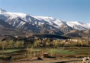
The High Atlas rises in the west at the Atlantic Ocean and stretches in an eastern direction to the Moroccan-Algerian border. At the Atlantic and to the southwest the range drops abruptly and makes an impressive transition to the coast and the Anti-Atlas range. To the north, in the direction of Marrakech, the range descends less abruptly.
The range includes Jbel Toubkal, which at 4,167 m is the highest in the range and lies in Toubkal National Park. The range serves as a weather system barrier in Morocco running east-west and separating the Sahara's climatic influences, which are particularly pronounced in the summer, from the more Mediterranean climate to the north, resulting in dramatic changes in temperature across the range. In the higher elevations in the range snow falls regularly, allowing winter sports. Snow lasts well into late spring in the High Atlas, mostly on the northern faces of the range.
The High Atlas forms the basins for a multiplicity of river systems. The majority of the year-round rivers flow to the north, providing the basis for the settlements there. A number of wadis and seasonal rivers terminate in the deserts to the south and plateaux to the east of the mountains.
The range
Western High Atlas
In the west lies the oldest portion of the range. Its high point is the Jbel Toubkal at 4167 m, which is visible from the city of Marrakech. Jbel Toubkal lies in the Toubkal national park, which was created in 1942. The massif consists of Jurassic and Cretaceous formations notched by deep erosion-carved valleys. This part of the range includes the Ourika Valley, which is the only location in the High Atlas where the endangered primate, the Barbary Macaque, Macaca sylvanus, is found; however, this primate is also found in parts of the Middle Atlas and the Rif, as well as parts of Algeria.[1] The Ourika Valley is also a location where a diverse flora was recorded as early as the 19th century.[2]
Central High Atlas
A solid chalk mass morphologically dominated by tabular zones reaching an altitude of 2,500 m extends from Azilal to Ouarzazate. Here, the contrasting landscapes remind visitors of the Colorado, with its high plateaux, its gorges and box canyons, and its peaks sometimes splintered by erosion. Several peaks in this area exceed 4000 m, with Jbel Mgoun at 4068 m being the highest peak in this part of the High Atlas. The area is populated by Berbers.
Eastern High Atlas
The eastern part of the High Atlas forms vast plateaux at high altitude which provide the headwaters for the Moulouya River. It extends from the town of Khenifra and includes oases at Jbel Ayachi (at 3747 m), Jbel Saghro and Jbel Sirwa (3305 m). This portion of the range includes the solid mass of the Tamlelt whose northern edge is occupied by its higher peaks, such Jbel Ayachi at 3,747 m. The altitude falls towards the east where the mountains join the pre-Saharan zone.
This massif became an internationally famous paleontological site after the discovery of the bones of the completely unknown ancestor of the dinosaurs, Atlasaurus, which populated Morocco 180 million years ago. This dinosaur is also named Tazoudasaurus, after the name of the village of Tazouda where it was discovered. The creature, about nine metres long, is postulated to be an ancestor of the Sauropoda found in America. Until 140 million years ago the African and American continents were connected.
Areas of interest
Travel over the high mountain passes is worthwhile. At the foot of the High Atlas one finds Aït Benhaddou, a Kasbah or castle still in use. Among the summits at 1600 m height lies the Kasbah of Telouet on the road to Marrakech.
The canyons and ravines of the Dadès and the Todra are also impressive.
See also
References
- C. Michael Hogan (2008) Barbary Macaque: Macaca sylvanus, Globaltwitcher.com, ed. Nicklas Stromberg
- Joseph Dalton Hooker, John Ball and George Maw (1878) Journal of a Tour in Marocco and the Great Atlas, Macmillan and company, 499 pages
Line notes
External links
| Wikimedia Commons has media related to High Atlas. |
 High Atlas travel guide from Wikivoyage
- Photo Gallery of Morocco and the High Atlas
- Accommodation in Imlil