Hich'apita
| Hich'apita | |
|---|---|
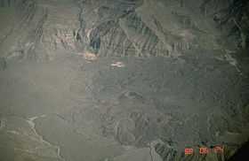 The "Valley of the Volcanoes" as seen from above with the volcanoes Ch'illkayuq and Hich'apita (on the right, in the background), Ch'illkayuq Grande (in the center) and Chachas Lake (on the bottom) | |
| Elevation | 3,388 m (11,115 ft) |
| Location | |
 Hich'apita Peru | |
| Location | Peru, Arequipa Region |
| Range | Andes |
| Coordinates | 15°32′05″S 72°18′39″W / 15.53472°S 72.31083°WCoordinates: 15°32′05″S 72°18′39″W / 15.53472°S 72.31083°W |
Hich'apita (Quechua,[1] hispanicized spelling Jechapita) is a volcano in the Andes of Peru, about 3,388 metres (11,115 ft) high.[2] It is situated in the "Valley of the Volcanoes" in the Arequipa Region, Castilla Province, Andagua District.[3] Hich'apita lies west of the Chachas Lake and north-west of the volcano Ch'illkayuq Grande and south of the volcano Ch'illkayuq.
References
- ↑ Diccionario Quechua - Español - Quechua, Academía Mayor de la Lengua Quechua, Gobierno Regional Cusco, Cusco 2005: hich'a - s. Derramamiento de algún líquido, harina, granos, etc. pitay - v. Fumar. Pe.Aya: pitay, mukay: Pe.Jun: mukai. Ec: sukuma.
- ↑ Mariusz Krzak, Ruch turystyczny w rejonie Arequipy i możliwości jego rozwoju w Dolinie Wulkanów (prowincja Castilla) w południowym Peru (Tourist movement in the Arequipa region and the possibilities of its development in the Valley of the Volcanoes (Castilla province) in Southern Peru), GeoTURYSTYKA, 2 (2005) 3-22 (In Polish containing a summary in English on p. 19-22)
- ↑ escale.minedu.gob.pe - UGEL Map of the Castilla Province (1) (Arequipa Region)