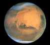
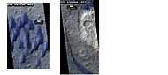
HiWish program
HiWish is a program created by NASA so that anyone can suggest a place for the HiRISE camera on the Mars Reconnaissance Orbiter to photograph.[1] It was started in January 2010. In the first few months of the program 3000 people signed up to use HiRISE.[2][3] The first images were released in April 2010.[4] Over 5000 suggestions were made by the public; suggestions were made for targets in each of the 30 quadrangles of Mars. Selected images released were used for three talks at the 16th Annual International Mars Society Convention. Below are some of the over 1100 images that have been released from the HiWish program as of March 2015.
Glacial features
Some landscapes look just like glaciers moving out of mountain valleys on Earth. Some have a hallowed out appearance, looking like a glacier after almost all the ice has disappeared. What is left are the moraines—the dirt and debris carried by the glacier. The center is hollowed out because the ice is mostly gone.[5] These supposed alpine glaciers have been called glacier-like forms (GLF) or glacier-like flows (GLF).[6] Glacier-like forms are a later and maybe more accurate term because we cannot be sure the structure is currently moving.[7]
,

|
-

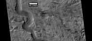
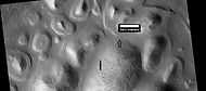
Possible glacier flowing down a valley and spreading out on a plain. Rectangle shows a portion that is enlarged in the next image.
-

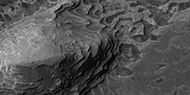
Enlargement of the area in the rectangle in the previous image. This area would be called a moraine in an alpine glacier on Earth.
-

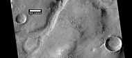
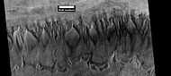
Well-developed hollows of concentric crater fill, as seen by HiRISE under the HiWish program.
Ancient rivers?
There is great deal of evidence that water once flowed in river valleys on Mars. Pictures from orbit show winding valleys, branched valleys, and even meanders with oxbow lakes.[8] Some are visible in the pictures below.
-
Channel on floor of Newton Crater, as seen by HiRISE under HiWish program.
-

Branched channel, as seen by HiRISE under HiWish program.
-

Branched channel, as seen by HiRISE under HiWish program.
-
Oxbow lake, as seen by HiRISE under HiWish program.
-

Valleys as seen by HiRISE under HiWish program
-

Channel in Arabia, as seen by HiRISE under HiWish program.
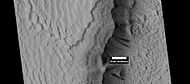
New Crater
-

HiRISE images showing discovery of a new crater with HiWish program
-

New crater, as seen by HiRISE under HiWish program. The new crater indicated with the white arrow is about 10 yards across and was probably created by the collision with an object the size of a large watermelon. This crater did not appear in earlier images of the same region.
Sand dunes
Many locations on Mars have sand dunes. The dunes are covered by a seasonal carbon dioxide frost that forms in early autumn and remains until late spring. Many martian dunes strongly resemble terrestrial dunes but images acquired by the High-Resolution Imaging Science Experiment on the Mars Reconnaissance Orbiter have shown that martian dunes in the north polar region are subject to modification via grainflow triggered by seasonal CO2 sublimation, a process not seen on Earth. Many dunes are black because they are derived from the dark volcanic rock basalt. Extraterrestrial sand seas such as those found on Mars are referred to as "undae" from the Latin for waves.
-
Dunes in two craters, as seen by HiRISE under the HiWish program.
-

Dunes among craters, as seen by HiRISE under HiWish program. Some of these are barchans.
-

Dunes on a crater floor, as seen by HiRISE under HiWish program. Most of these are barchans. Box shows location of next image.
-

Dunes on a crater floor, as seen by HiRISE under HiWish program. Most of these are barchans. Note: this is an enlargement of the center of the previous image.
-
Dunes, as seen by HiRISE under HiWish program. Location is Eridania quadrangle.
Landing site
Some of the targets suggested became possible sites for a Rover Mission in 2020. The targets were in Firsoff (crater). This crater was picked as one of 26 locations considered for a mission that will look for signs of life and gather samples for a later return to Earth.[9][10][11]
-
Layers in Firsoff Crater, as seen by HiRISE under HiWish program Note: this image field can be found in the previous image of the layers in Firsoff Crater, as seen by CTX camera (on Mars Reconnaissance Orbiter).
-

Close-up of layers in Firsoff Crater, as seen by HiRISE Note: this is an enlargement of the previous image of Firsoff Crater.
-

Layers in Firsoff crater with a box showing the size of a football field Picture taken by HiRISE under HiWish program.
-

Layers and faults in Firsoff Crater, as seen by HiRISE under HiWish program. Arrows show one large fault, but there are other smaller ones in the picture.
Landscape features
-

Troughs to the East of Albor Tholus, as seen by HiRISE under the HiWish program.
-

Portion of a trough (Fossae) in Elysium Planitia, as seen by HiRISE under the HiWish program. Blue indicates possible seasonal frost.
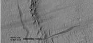
Dark slope streaks
-
Layers and dark slope streaks, as seen by HiRISE under HiWish program
-

Dark slope streaks on mesa, as seen by HiRISE under HiWish program Location is Amazonis quadrangle.
-
Close-up of some layers under cap rock of a pedestal crater and a dark slope streak, as seen by HiRISE under HiWish program.
-

Dark slope streaks and layers near a pedestal crater, as seen by HiRISE under the HiWish program. Arrows show the small starting points for the streaks.
Layers
Many places on Mars show rocks arranged in layers. Rock can form layers in a variety of ways. Volcanoes, wind, or water can produce layers.[12] Layers can be hardened by the action of groundwater.
,
-
Layers exposed at the base of a group of buttes in Mangala Valles in Memnonia quadrangle, as seen by HiRISE under HiWish program. Arrows point to boulders sitting in pits. The pits may have formed by winds, heat from the boulders melting ground ice, or some other process.
-

Buttes, as seen by HiRISE under HiWish program. Buttes have layered rocks with a hard resistant cap rock on the top which protects the underlying rocks from erosion.
-

Butte in Crommelin Crater, as seen by HiRISE under HiWish program. Location is Oxia Palus quadrangle.
-
Layers in Crommelin Crater, as seen by HiRISE under HiWish program. Location is Oxia Palus quadrangle.
-

Light toned butte, as seen by HiRISE, under HiWish program. Light toned material is probably sulfate-rich and similar to material examined by Spirit Rover, and it once probably covered the whole floor.
-

Layered terrain in Aeolis quadrangle, as seen by HiRISE under HiWish program.
-

Layers in Arabia, as seen by HiRISE under HiWish program.
Gullies
Martian gullies are small, incised networks of narrow channels and their associated downslope sediment deposits, found on the planet of Mars. They are named for their resemblance to terrestrial gullies. First discovered on images from Mars Global Surveyor, they occur on steep slopes, especially on the walls of craters. Usually, each gully has a dendritic alcove at its head, a fan-shaped apron at its base, and a single thread of incised channel linking the two, giving the whole gully an hourglass shape.[13] They are believed to be relatively young because they have few, if any craters.
On the basis of their form, aspects, positions, and location amongst and apparent interaction with features thought to be rich in water ice, many researchers believed that the processes carving the gullies involve liquid water. However, this remains a topic of active research.
,

|
-

Close-up of gully aprons showing they are free of craters; hence very young. Location is Phaethontis quadrangle. Picture was taken by HiRISE under HiWish program.
-

Gullies on wall of crater, as seen by HiRISE under HiWish program Location is the Mare Acidalium quadrangle.
-

Close-up of gully channels, as seen by HiRISE under HiWish program. This image shows many streamlined forms and some benches along a channel. These features suggest formation by running water. Benches are usually formed when the water level goes down a bit and stays at that level for a time. Picture was taken with HiRISE under HiWish program. Location is the Mare Acidalium quadrangle. Note this is an enlargement of a previous image.
-
Gullies in crater in Phaethontis quadrangle, as seen by HiRISE under HiWish program
Scalloped topography
Scalloped topography is common in the mid-latitudes of Mars, between 45° and 60° north and south. It is particularly prominent in the region of Utopia Planitia[14][15] in the northern hemisphere and in the region of Peneus and Amphitrites Patera[16][17] in the southern hemisphere. Such topography consists of shallow, rimless depressions with scalloped edges, commonly referred to as "scalloped depressions" or simply "scallops". Scalloped depressions can be isolated or clustered and sometimes seem to coalesce. A typical scalloped depression displays a gentle equator-facing slope and a steeper pole-facing scarp. This topographic asymmetry is probably due to differences in insolation. Scalloped depressions are believed to form from the removal of subsurface material, possibly interstitial ice, by sublimation. This process may still be happening at present.[18]
-

Scalloped ground, as seen by HiRISE under HiWish program.
-

Close up of scalloped ground, as seen by HiRISE under HiWish program. Surface is divided into polygons; these forms are common where ground freezes and thaws. Note: this is an enlargement of a previous image.
-

Scalloped ground, as seen by HiRISE under HiWish program.
-

Close-up of scalloped ground, as seen by HiRISE under HiWish program. Surface is divided into polygons; these forms are common where ground freezes and thaws. Note: this is an enlargement of a previous image.
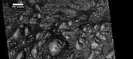
Ring mold craters
Ring mold craters are believed to be formed from asteroid impacts into ground that has an underlying layer of ice. The impact produces an rebound of the ice layer to form a "ring-mold" shape.
,
-

Ring mold craters of various sizes on floor of a crater, as seen by HiRISE under HiWish program Location is Ismenius Lacus quadrangle.
-

Wide view of a field of ring mold craters, as seen by HiRISE under HiWish program
-

Close view of ring mold crater, as seen by HiRISE under HiWish program Note: this is an enlargement of the previous image of a field of ring mold craters.
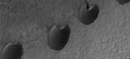
Dust devil tracks
Dust devil tracks can be very pretty. They are caused by giant dust devils removing bright colored dust from the Martian surface; thereby exposing a dark layer.
-

Dust devil tracks, as seen by HiRISE under HiWish program.
-

Dust devil tracks, as seen by HiRISE under HiWish program
To suggest a location for HiRISE to image visit the site at http://www.uahirise.org/hiwish
See also
- Climate of Mars
- Geology of Mars
- Glaciers
- Glaciers on Mars
- Barchan
- Groundwater on Mars
- Martian gullies
References
- ↑ "Public Invited To Pick Pixels On Mars". Mars Daily. January 22, 2010. Retrieved January 10, 2011.
- ↑ Interview with Alfred McEwen on Planetary Radio, 3/15/2010
- ↑ http://www.planetary.org/multimedia/planetary-radio/show/2010/384.html
- ↑ "NASA releases first eight "HiWish" selections of people’s choice Mars images". TopNews. April 2, 2010. Retrieved January 10, 2011.
- ↑ Milliken, R., J. Mustard, D. Goldsby. 2003. Viscous flow features on the surface of Mars: Observations from high-resolution Mars Orbiter Camera (MOC) images. J. Geophys. Res. 108. doi:10.1029/2002JE002005.
- ↑ Arfstrom, J and W. Hartmann. 2005. Martian flow features, moraine-like ridges, and gullies: Terrestrial analogs and interrelationships. Icarus 174, 321-335.
- ↑ Hubbard B., R. Milliken, J. Kargel , A. Limaye, C. Souness . 2011. Geomorphological characterisation and interpretation of a mid-latitude glacier-like form: Hellas Planitia, Mars Icarus 211, 330–346
- ↑ Baker, V. 1982. The Channels of Mars. Univ. of Tex. Press, Austin, TX
- ↑ http://marsnext.jpl.nasa.gov/workshops/index.cfm
- ↑ http://hirise.lpl.arizona.edu/ESP_039404_1820
- ↑ Pondrelli, M., A. Rossi, L. Deit, S. van Gasselt, F. Fueten, E. Hauber, B. Cavalazzi, M. Glamoclija, and F. Franchi. 2014. A PROPOSED LANDING SITE FOR THE 2020 MARS MISSION: FIRSOFF CRATER. http://marsnext.jpl.nasa.gov/workshops/2014_05/33_Pondrelli_Firsoff_LS2020.pdf
- ↑ "HiRISE | High Resolution Imaging Science Experiment". Hirise.lpl.arizona.edu?psp_008437_1750. Retrieved 2012-08-04.
- ↑ Malin, M., Edgett, K. 2000. Evidence for recent groundwater seepage and surface runoff on Mars. Science 288, 2330–2335.
- ↑ Lefort, A.; Russell, P. S.; Thomas, N.; McEwen, A. S.; Dundas, C. M.; Kirk, R. L. (2009). "Observations of periglacial landforms in Utopia Planitia with the High Resolution Imaging Science Experiment (HiRISE)". Journal of Geophysical Research 114 (E4). Bibcode:2009JGRE..11404005L. doi:10.1029/2008JE003264.
- ↑ Morgenstern, A; Hauber, E; Reiss, D; van Gasselt, S; Grosse, G; Schirrmeister, L (2007). "Deposition and degradation of a volatile-rich layer in Utopia Planitia, and implications for climate history on Mars" (PDF). Journal of Geophysical Research - Planets 112 (E6): E06010. Bibcode:2007JGRE..11206010M. doi:10.1029/2006JE002869.
- ↑ Lefort, A.; Russell, P.S.; Thomas, N. (2010). "Scalloped terrains in the Peneus and Amphitrites Paterae region of Mars as observed by HiRISE". Icarus 205 (1): 259. Bibcode:2010Icar..205..259L. doi:10.1016/j.icarus.2009.06.005.
- ↑ Zanetti, M.; Hiesinger, H.; Reiss, D.; Hauber, E.; Neukum, G. (2009). "Scalloped Depression Development on Malea Planum and the Southern Wall of the Hellas Basin, Mars" (PDF). Lunar and Planetary Science 40. p. 2178, abstract 2178. Bibcode:2009LPI....40.2178Z.
- ↑ http://hiroc.lpl.arizona.edu/images/PSP?diafotizo.php?ID=PSP_002296_1215
Recommended reading
- Lorenz, R. 2014. The Dune Whisperers. The Planetary Report: 34, 1, 8-14
- Lorenz, R., J. Zimbelman. 2014. Dune Worlds: How Windblown Sand Shapes Planetary Landscapes. Springer Praxis Books / Geophysical Sciences.
- Grotzinger, J. and R. Milliken (eds.). 2012. Sedimentary Geology of Mars. SEPM.
External links
- Martian Ice - Jim Secosky - 16th Annual International Mars Society Convention
- https://www.youtube.com/watch?v=RYG-HLr33CM Martian Geology - Jim Secosky - 16th Annual International Mars Society Convention
- https://www.youtube.com/watch?v=ZNTNzQy1_UA Walks on Mars - Jim Secosky - 16th Annual International Mars Society Convention