Herrieden
| Herrieden | ||
|---|---|---|
| ||
 Herrieden | ||
Location of Herrieden within Ansbach district 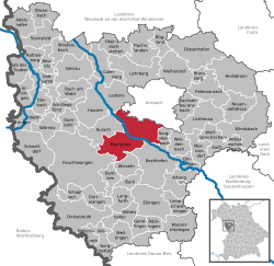 | ||
| Coordinates: 49°13′N 10°31′E / 49.217°N 10.517°ECoordinates: 49°13′N 10°31′E / 49.217°N 10.517°E | ||
| Country | Germany | |
| State | Bavaria | |
| Admin. region | Mittelfranken | |
| District | Ansbach | |
| Government | ||
| • Mayor | Alfons Brandl (CSU) | |
| Area | ||
| • Total | 81.71 km2 (31.55 sq mi) | |
| Population (2013-12-31)[1] | ||
| • Total | 7,636 | |
| • Density | 93/km2 (240/sq mi) | |
| Time zone | CET/CEST (UTC+1/+2) | |
| Postal codes | 91567 | |
| Dialling codes | 09825 | |
| Vehicle registration | AN | |
| Website | www.herrieden.de | |
Herrieden is a town in the district of Ansbach and situated in the Middle Franconia region of Bavaria, Germany. It lies along the upper Altmühl river, about 9 km (6 mi) southwest of the city of Ansbach, 47 km southwest of the city of Nürnberg, 95 km east of Heilbronn and 144 km northwest of Munich. It is part of a cooperative with the nearby small cities of Aurach, Burgoberbach, and Leutershausen. Herrieden is located close to the A6 autobahn between Nürnberg and Heilbronn. Herrieden is administratively over the large towns of Neunstetten to the north, Rauenzell to the east and Elbersroth to the southwest. Other towns and villages administratively under Herrieden include Birkach, Bittelhof, Böckau, Brünst, Buschhof, Esbach, Gimpertshausen, Gräbenwinden, Heuberg, Höfstetten, Hohenberg, Lammelbach, Lattenbuch, Leibelbach, Leuckersdorf, Leutenbuch, Limbach, Manndorf, Mühlbruck, Niederdombach, Oberschönbronn, Regmannsdorf, Rös, Roth, Sauerbach, Schernberg, Schönau, Seebronn, Sickersdorf, Stadel, Stegbruck, Steinbach, Velden and Winn.
The first recorded settlement of Herrieden was a monastery called Hasenried (Latin Nazaruda) in 782.[2]
References
- ↑ "Fortschreibung des Bevölkerungsstandes". Bayerisches Landesamt für Statistik und Datenverarbeitung (in German). 31 December 2013.
- ↑ Cf. Notitia de servitio monasteriorum.
External links
| Wikimedia Commons has media related to Herrieden. |