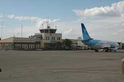
Herat International Airport
| Herat International Airport Persian: میدان هوایی بین المللی هرات | |||||||||||
|---|---|---|---|---|---|---|---|---|---|---|---|
|
A Pamir Airways parked at the airport in 2010 | |||||||||||
 HEA | |||||||||||
| Summary | |||||||||||
| Airport type | Public/Military | ||||||||||
| Owner | Afghanistan | ||||||||||
| Operator | Afghan Ministry of Transport and Civil Aviation / ISAF | ||||||||||
| Location | Herat | ||||||||||
| Elevation AMSL | 3,205 ft / 977 m | ||||||||||
| Coordinates | 34°12′36.2″N 62°13′40.6″E / 34.210056°N 62.227944°ECoordinates: 34°12′36.2″N 62°13′40.6″E / 34.210056°N 62.227944°E | ||||||||||
| Runways | |||||||||||
| |||||||||||
|
Source: Landings.com[1] | |||||||||||
Herat International Airport[2] (IATA: HEA, ICAO: OAHR) is located 10.5 km (6.5 mi) southeast of the city of Herat in western Afghanistan, east of the Herat-Farah road, close to Guzara in the Guzara District of the Herat Province. It is Afghanistan's the third largest commercial airport after Kabul International Airport, and Kandahar International Airport.[2]
History
The airport was originally built by engineers from the United States in the late 1950s. During the 1980s Soviet war, it was heavily used by the Soviets to launch bombardment missions on Mujahideen rebel forces. The airport was a base for military fighters and transport aircraft (likely Antonov An-26, Antonov An-32 and Mikoyan-Gurevich MiG-21). During the late 2001 Operation Enduring Freedom, it was bombed by US and/or British aircraft. On 12 November 2001, the 2001 uprising in Herat broke out, and the Taliban were ousted from the area. Elements of the U.S. Army Special Forces Operational Detachment Alpha 554 ("Texas 08") arrived at the airport soon afterwards, and in the words of the team's report: "..directly negotiate with local commanders for the placement of multinational humanitarian assistance teams to be stationed" at the airport.[3] From 2002 to 2005, the U.S.-led coalition forces ran international operations at the airport.
In May 2005, responsibility was shifted to the International Security Assistance Force (ISAF), as part of the Stage 2 transition between the U.S.-led coalition and NATO. For 45 days a 47-person Tanker Airlift Control Element, primarily deployed from the 621st Contingency Response Wing, McGuire Air Force Base, N.J. prepared the airport for the arrival of 300+ Italian troops as they assumed leadership over ISAF operations in the western regions of Afghanistan.[4] For this particular tasking, they supported two C-17 sorties every day. They also assisted the Italian aerial port in servicing coalition C-130s that landed at the airport.
ISAF use has continued since 2005, joined by the Afghan National Army Air Corps, now Afghan Air Force, and the Afghan National Police. In recent years Italy has pledged 137 million Euros for the expansion of the airport.[2] As a result the runway was extended and re-paved and a new international terminal, named after Captain Massimo Ranzani, a fallen Italian officer, was opened.[5] In 2011 and the airport became known as Herat International Airport.
Airlines and destinations
| Airlines | Destinations |
|---|---|
| Afghan Jet International | Kabul[6] |
| Ariana Afghan Airlines | Kabul[7] |
| East Horizon Airlines | Chaghcharan, Farah, Kabul, Maymana, Zaranj[8] |
| Kam Air | Kabul, Mazar-i-Sharif[9] |
| Safi Airways | Kabul[10] |
See also
References
- ↑ Airport record for Herat Airport at Landings.com. Retrieved 1 August 2013
- ↑ 2.0 2.1 2.2 Karzai briefed on Herat airport expansion map
- ↑ Dick Camp, 'Boots on the Ground: The Fight to Liberate Afghanistan,' Zenith Imprint, January 2012, 212.
- ↑ Globalsecurity.org, Herat Airfield military role, accessed August 2013.
- ↑ New Herat airport terminal named after fallen Italian soldier
- ↑ Afghan Jet route map
- ↑ May 2014 Ariana Timetable, http://www.flyariana.com/sched/view.asp
- ↑ 2014 Timetable, http://flyeasthorizon.com/flight-schedule/
- ↑ https://www.kamair.com/route-map2.php
- ↑ Safi Airways, August 2014 Schedule, http://www.safiairways.com/schedule
External links
- Ariana Afghan Airlines schedule
- Airport record for Herat Airport at Landings.com
- Current weather for OAHR at NOAA/NWS
| ||||||||||||||||||
| ||||||||||||||||||||||
