Heolgerrig
| Heolgerrig | |
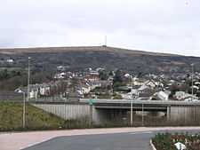 The village of Heolgerrig with the A470 trunk road in the foreground and Mynydd Aberdâr beyond |
|
 Heolgerrig |
|
| OS grid reference | SO034067 |
|---|---|
| Principal area | Merthyr Tydfil |
| Ceremonial county | Mid Glamorgan |
| Country | Wales |
| Sovereign state | United Kingdom |
| Post town | Merthyr Tydfil |
| Postcode district | CF48 |
| Dialling code | 01685 |
| Police | South Wales |
| Fire | South Wales |
| Ambulance | Welsh |
| EU Parliament | Wales |
| UK Parliament | Merthyr Tydfil and Rhymney |
| Welsh Assembly | Merthyr Tydfil and Rhymney |
|
|
Coordinates: 51°44′45″N 3°24′10″W / 51.7459°N 3.4028°W
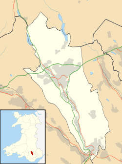
Heolgerrig (Welsh for "stony road"; formerly "Pen-yr-Heolgerrig") is a small village in Merthyr Tydfil County Borough, Wales, adjacent to the recently constructed Cyfarthfa Retail Park. It is part of the community of Cyfarthfa.[1]
.JPG)
Calfaria chapel in Heolgerrig, Merthyr Tydfil.
It lies just west of Merthyr Tydfil, and is separated from it by the main A470 trunk road.
Village amenities include the Heolgerrig primary school, the Red Lion (Llew Coch) pub, two chapels and a post office.
Notes
- ↑ Davies, John; Jenkins, Nigel; Menna, Baines; Lynch, Peredur I., eds. (2008). The Welsh Academy Encyclopaedia of Wales. Cardiff: University of Wales Press. p. 554. ISBN 978-0-7083-1953-6.
External links
- Old Merthyr Tydfil: Heolgerrig - Historical Photographs of Heolgerrig, Merthyr Tydfil.