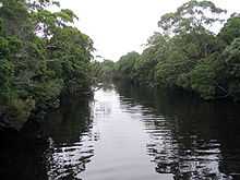
Henty River
Henty River Is a river in West Coast, Tasmania to the west of the West Coast Range, it lies north of Queenstown and south of Zeehan.
Very close to its source - at the headwaters - in the area known as the Upper Henty [1][2] - is the Henty Gold Mine, which is north west of Mount Tyndall.
Its upper reaches were some of the last sites of dam making by the Hydro Tasmania in its long history of regulating flow of Tasmanian rivers.
The river basin which is adjacent to the West Coast Range and the Lake Margaret areas is argued as having up to four separate periods of glaciation [3]
During October and November, the Henty River is a location for sea run trout.
Picnic spots are available beside the river at either the Strahan to Zeehan highway, or the Zeehan Highway.
It was crossed by two bridges, one still exists - on the Zeehan-Queenstown highway, and the former bridge of the Strahan-Zeehan Railway very close to the coast and Ocean Beach.
Notes
- ↑ Taylor, R. J. and others (July 1985), "Mammals of the upper Henty River region, Western Tasmania", Papers and Proceedings of the Royal Society of Tasmania 119 (July 1985): 7–14, retrieved 9 June 2012
- ↑ Taylor, RJ (1986), Notes on the diet of the carnivorous mammals of the Upper Henty River Region, western Tasmania, retrieved 9 June 2012
- ↑ Augustinus, PC; Colhoun, EA (1995), Weathering and morphostratigraphic evidence for four glaciations in the Henty River Basin, western Tasmania, retrieved 9 June 2012
Further reading
- Blainey, Geoffrey (2000). The Peaks of Lyell (6th ed. ed.). Hobart: St. David's Park Publishing. ISBN 0-7246-2265-9.
- Whitham, Charles. Western Tasmania: A Land of Riches and Beauty.
- 2003 edition - Queenstown: Municipality of Queenstown.
- 1949 edition - Hobart: Davies Brothers. OCLC 48825404; ASIN B000FMPZ80
- 1924 edition - Queenstown: Mount Lyell Tourist Association. OCLC 35070001; ASIN B0008BM4XC
External links
Coordinates: 42°01′S 145°13′E / 42.017°S 145.217°E