Henry Clay, Kentucky
| Henry Clay | |
|---|---|
| Unincorporated community | |
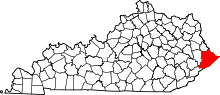
 Henry Clay Location within the state of Kentucky | |
| Coordinates: 37°18′41″N 82°28′36″W / 37.31139°N 82.47667°WCoordinates: 37°18′41″N 82°28′36″W / 37.31139°N 82.47667°W | |
| Country | United States |
| State | Kentucky |
| County | Pike |
| Elevation | 1,020 ft (310 m) |
| Time zone | Central (CST) (UTC-6) |
| • Summer (DST) | CST (UTC-5) |
| GNIS feature ID | 494057[1] |
Henry Clay is an unincorporated community and coal town located in Pike County, Kentucky, United States. It was also known as the Henry Clay Coal Camp.