Henricus Martellus Germanus

Henricus Martellus Germanus is the latinized name of Heinrich Hammer, a German cartographer who lived and worked in Florence from 1480 to 1496.
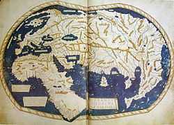
Around 1489 or 1490, he produced a world map which was remarkably similar to the terrestrial globe later produced by Martin Behaim in 1492, the Erdapfel. Both show novel adaptions of the existing Ptolemaic model, opening a passage south of Africa and creating an enormous new peninsula east of the Golden Chersonese (Malaysia). Both possibly derive from maps created around 1485 in Lisbon by Bartolomeo Columbus.
One of his two manuscript world maps, 201 cm x 122 cm in size, rediscovered in 1960, was donated to Yale's Beinecke Rare Book and Manuscript Library.[1]
The other similar manuscript world map is in the British Library.[2]
Martellus also in 1484 produced an Insularium Illustratum ("Illustrated Book of Islands"), containing maps.[3]
Variants of the name
- Henricus Martellus Germanus
- Henricus (Germanus)
- Enrico Martello
- Henricus Martellus
- Martellus
- Heinrich Hammer
Map (online)
References
External links
- Arthur Davies: Behaim, Martellus and Columbus, The Geographical Journal, Vol. 143, No. 3 (Nov., 1977), pp. 451-459
- Alexander O. Vietor: A Pre-Columbian Map of the World, Circa 1489, Imago Mundi, Vol. 17, 1963 (1963), pp. 95-96
- Index of Cartographic Images
- An essay on the world maps created by Henricus Martellus Germanus
- SUB GÖ
- http://www.halifax.ca/cah/documents/earlyportuguese.pdf
- http://www.danstopicals.com/germanus.htm