Hellenthal
| Hellenthal | ||
|---|---|---|
| ||
 Hellenthal | ||
Location of Hellenthal within Euskirchen district 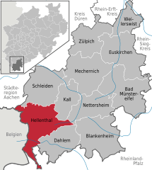
 | ||
| Coordinates: 50°28′59″N 06°25′59″E / 50.48306°N 6.43306°ECoordinates: 50°28′59″N 06°25′59″E / 50.48306°N 6.43306°E | ||
| Country | Germany | |
| State | North Rhine-Westphalia | |
| Admin. region | Köln | |
| District | Euskirchen | |
| Government | ||
| • Mayor | Manfred Ernst | |
| Area | ||
| • Total | 138 km2 (53 sq mi) | |
| Population (2013-12-31)[1] | ||
| • Total | 8,011 | |
| • Density | 58/km2 (150/sq mi) | |
| Time zone | CET/CEST (UTC+1/+2) | |
| Postal codes | 53940 | |
| Dialling codes | 02482, 02448 | |
| Vehicle registration | EU | |
| Website | www.hellenthal.de | |

Hellenthal is a municipality in the district of Euskirchen in the state of North Rhine-Westphalia, Germany. It is located in the Eifel hills, near the border with Belgium, approx. 30 km south-west of Euskirchen and 40 km south-east of Aachen.
The village Reifferscheid, part of the municipality of Hellenthal, is dominated by the ruins of the Burg Reifferscheid, that was the seat of a medieval principality, see Salm. Another village within the municipality, Blumenthal, features ironworks industry area.
References
- ↑ "Amtliche Bevölkerungszahlen". Landesbetrieb Information und Technik NRW (in German). 4 September 2014.
| ||||||||