Hellas quadrangle
|
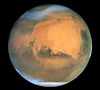
Map of Hellas quadrangle from Mars Orbiter Laser Altimeter (MOLA) data. The highest elevations are red and the lowest are blue. | |
| Coordinates | 47°30′S 270°00′W / 47.5°S 270°WCoordinates: 47°30′S 270°00′W / 47.5°S 270°W |
|---|---|


The Hellas quadrangle is one of a series of 30 quadrangle maps of Mars used by the United States Geological Survey (USGS) Astrogeology Research Program. The Hellas quadrangle is also referred to as MC-28 (Mars Chart-28).[1] The Hellas quadrangle covers the area from 240° to 300° west longitude and 30° to 65° south latitude on the planet Mars. Within the Hellas quadrangle lies the classic features Hellas Planitia and Promethei Terra. Many interesting and mysterious features have been discovered in the Hellas quadrangle, including the giant river valleys Dao Vallis, Niger Vallis, Harmakhis, and Reull Vallis—all of which may have contributed water to a lake in the Hellas basin in the distant past.[2][3][4] Many places in the Hellas quadrangle show signs of ice in the ground, especially places with glacier-like flow features.
Hellas Basin
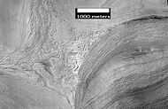
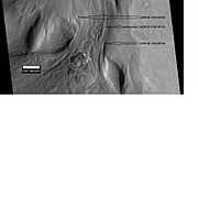
The Hellas quadrangle contains part of the Hellas Basin, the largest known impact crater on the surface of Mars and the second largest in the solar system. The depth of the crater is 7152 m[5] (23,000 ft) below the standard topographic datum of Mars. The basin is located in the southern highlands of Mars and is thought to have been formed about 3.9 billion years ago, during the Late Heavy Bombardment. Studies suggest that when an impact created the Hellas Basin, the entire surface of Mars was heated hundreds of degrees, 70 meters of molted rock fell on the planet, and an atmosphere of gaseous rock was formed. This rock atmosphere was 10 times as thick as the Earth's atmosphere. In a few days, the rock would have condensed out and covered the whole planet with an additional 10 m of molten rock.[2] In the Northwest portion of Hellas Planitia is a strange type of surface called complex banded terrain or taffy-pull terrain. Its process of formation is still largely unknown, although it appears to be due to erosion of hard and soft sediment along with ductile deformation. Ductile deformation results from layers undergoing strain.[6]
Early in the planet's history, it is believed that a giant lake existed in the Hellas Basin. Possible shorelines have been discovered.[3] Glacial features (terminal moraines, drumlins, and eskers) have been found that may have been formed when the water froze.[2][7]
-

Hellas Basin Area topography. Crater depth is 7152 m[1] (23,000 ft) below the standard topographic datum of Mars.
-
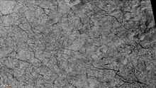
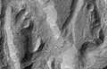
Twisted Ground in Hellas, as seen by HiRISE. This is one more example of how difficult it would be to walk on Mars.

- ^ Cite error: The named reference
stanhellaswas invoked but never defined (see the help page).
Lobate Debris Aprons
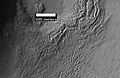
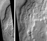
One very important feature common in east Hellas are piles of material surrounding cliffs. The formation is called a Lobate Debris Apron (LDA's). Recently, research with the Shallow Radar on the Mars Reconnaissance Orbiter has provided strong evidence that the LDA's are glaciers that are covered with a thin layer of rocks.[8][9][10][11][12] Large amounts of water ice are believed to be in the LDA's. Available evidence strongly suggests that the eastern part of Hellas accumulated snow in the past. When the tilt (obliquity) of Mars increases the southern ice cap releases large amounts of water vapor. Climate models predict that when this occurs, water vapor condenses and falls where LDAs are located. The tilt of the earth changes little because our relatively large moon keeps it stable. The two tiny Martian moons do not stabilize their planet, so the rotational axis of Mars undergoes large variations.[13] Lobate Debris Approns may be a major source of water for future Mars colonists. Their major advantage over other sources of Martian water are that they can easily mapped from orbit and they are closer to the equator where manned missions are more likely to land.
-

Close-up of surface of a Lobate Debris Apron. Note the lines that are common in rock glaciers on the Earth. Image located in Hellas quadrangle.
-

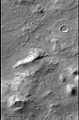
CTX Context image for next two images of debris apron around mound.
-
Surface of Debris Apron. There is also a feature similar to features in Red Rocks Park Colorado. Feature seems to be composed of slanted rock layers. Image taken with HiRISE, under the HiWish program.
-
Surface of debris apron in Terra Cimmeria, as seen by HiRISE, under the HiWish program. Colored parts may be frost deposits.
Lineated Floor Deposits
On the floors of some channels are features called lineated floor deposits. They are ridged and grooved materials that seem to deflect around obstacles. They are believed to be ice-rich. Some glaciers on the Earth show such features. Lineated floor deposits may be related to lobate debris aprons, which have been proven to contain large amounts of ice. Reull Vallis, as pictured below, displays these deposits.[14]
-

Drainage features in Reull Vallis, as seen by THEMIS. Click on image to see relationship of Reull Vallis to other features.
-
Reull Vallis with lineated floor deposits, as seen by THEMIS. Click on image to see relationship to other features.
-
Layers in Reull Vallis, as seen by THEMIS.
-

Fretted terrain near Reull Vallis, as seen by HiRISE.
-
Close-up of Fretted Terrain near Reull Vallis, as seen by HiRISE. This area would be a challenge to walk across.
-

Layers in Monument Valley. These are accepted as being formed, at least in part, by water deposition. Since Mars contains similar layers, water remains as a major cause of layering on Mars.
Ice-rich mantle

Much of the surface of Mars is covered by a thick smooth mantle that is thought to be a mixture of ice and dust. This ice-rich mantle, a few yards thick, smoothes the land, but in places it displays a bumpy texture, resembling the surface of a basketball. Because there are few craters on this mantle, the mantle is relatively young. The image at the right shows a good view of this smooth mantle around Niger Vallis, as observed with HiRISE. Changes in Mars's orbit and tilt cause significant changes in the distribution of water ice from polar regions down to latitudes equivalent to Texas. During certain climate periods water vapor leaves polar ice and enters the atmosphere. The water returns to the ground at lower latitudes as deposits of frost or snow mixed generously with dust. The atmosphere of Mars contains a great deal of fine dust particles. Water vapor condenses on the particles, then they fall down to the ground due to the additional weight of the water coating. When ice at the top of the mantling layer goes back into the atmosphere, it leaves behind dust, which insulates the remaining ice.[15]
Climate change caused ice-rich features
Many features on Mars, including ones in Hellas quadrangle, are believed to contain large amounts of ice. The most popular model for the origin of the ice is climate change from large changes in the tilt of the planet's rotational axis. At times the tilt has even been greater than 80 degrees[16][17] Large changes in the tilt explains many ice-rich features on Mars.
Studies have shown that when the tilt of Mars reaches 45 degrees from its current 25 degrees, ice is no longer stable at the poles.[18] Furthermore, at this high tilt, stores of solid carbon dioxide (dry ice) sublimate, thereby increasing the atmospheric pressure. This increased pressure allows more dust to be held in the atmosphere. Moisture in the atmosphere will fall as snow or as ice frozen onto dust grains. Calculations suggest this material will concentrate in the mid-latitudes.[19][20] General circulation models of the Martian atmosphere predict accumulations of ice-rich dust in the same areas where ice-rich features are found.[21] When the tilt begins to return to lower values, the ice sublimates (turns directly to a gas) and leaves behind a lag of dust.[22][22][23] The lag deposit caps the underlying material so with each cycle of high tilt levels, some ice-rich mantle remains behind.[24] Note, that the smooth surface mantle layer probably represents only relative recent material.
Origin of Dao Vallis

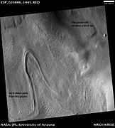
Dao Vallis begins near a large volcano, called Hadriaca Patera, so it is thought to have received water when hot magma melted huge amounts of ice in the frozen ground.[2] The partially circular depressions on the left side of the channel in the image to the right suggests that groundwater sapping also contributed water.[25]
Dust devil tracks
Many areas on Mars, including the Hellas quadrangle, experience the passage of giant dust devils. A thin coating of fine bright dust covers most of the martian surface. When a dust devil goes by it blows away the coating and exposes the underlying dark surface. Dust devils have been seen from the ground and from orbiting spacecraft. They have even blown the dust off of the solar panels of the two Rovers on Mars, thereby greatly extending their lives.[26] The twin Rovers were designed to last for 3 months, instead they have lasted more than five years and are still going. The pattern of the tracks have been shown to change every few months.[27] A study that combined data from the High Resolution Stereo Camera (HRSC) and the Mars Orbiter Camera (MOC) found that some large dust devils on Mars have a diameter of 700 meters and last at least 26 minutes.[28]
Evidence for possible recent liquid water

The Mars Reconnaissance Orbiter discovered changes on the wall of Penticton Crater between 1999 and 2004. One interpretation of the changes was that they were caused by water flowing on the surface.[29] A further analysis, published about a year later, revealed that the deposit could have been caused by gravity moving material down slope (a landslide). The slope where the deposit was sighted was close to the stability limits of dry, unconsolidated materials.[30]
Other Craters
Impact craters generally have a rim with ejecta around them, in contrast volcanic craters usually do not have a rim or ejecta deposits. As craters get larger (greater than 10 km in diameter) they usually have a central peak.[31] The peak is caused by a rebound of the crater floor following the impact.[32] Sometimes craters will display layers. Craters can show us what lies deep under the surface.
-
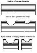
Pedestal craters form when the ejecta from impacts protect the underlying material from erosion. As a result of this process, craters appear perched above their surroundings.
-

Drawing shows a later idea of how some pedestal craters form. In this way of thinking, an impacting projectile goes into an ice-rich layer—but no further. Heat and wind from the impact hardens the surface against erosion. This hardening can be accomplished by the melting of ice which produces a salt/mineral solution thereby cementing the surface.
-

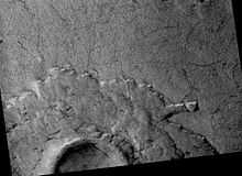
Stair-stepping mesas in interior deposit of Spallanzani Crater, as seen by THEMIS
-
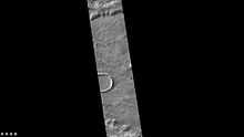
Penticton Crater gullies, as seen by HiRISE
-
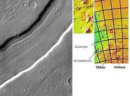
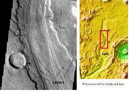
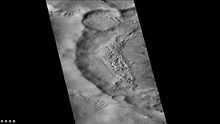
Lipik Crater Channels, as seen by THEMIS.
-

Tikhov Crater, as seen by CTX camera (on Mars Reconnaissance Orbiter).
-
Floor of Wallace Crater, as seen by CTX camera (on[Mars Reconnaissance Orbiter).
-
Dust devil tracks on floor of Wallace Crater, as seen by CTX camera (on Mars Reconnaissance Orbiter). Note this is an enlargement of the previous image of the floor of Wallace Crater.
-

Huxley Crater, as seen by CTX camera (on Mars Reconnaissance Orbiter).
-

Gledhill Crater, as seen by CTX camera (on Mars Reconnaissance Orbiter).
-
Le Verrier (Martian Crater), as seen by CTX camera (on Mars Reconnaissance Orbiter).
-
Redi Crater, as seen by CTX camera (on Mars Reconnaissance Orbiter).
-
Redi Crater, showing dust devil tracks and mantle, as seen by CTX camera (on Mars Reconnaissance Orbiter). Note: this is an enlargement of the previous image of Redi Crater.
Glacial Features
-
Surface features that show down hill movement, as seen by HiRISE.
-
CTX context image of Hellas Planitia showing location of next two images.
-

Surface in Hellas quadrangle, as seen by HiRISE, under the HiWish program.
-

Possible Glacial Cirque in Hellas Planitia, as seen by HiRISE, under the HiWish program. Lines are probably due to downhill movement.
-

Elephant Foot Glacier in the Earth's Arctic , as seen by Landsat 8. This picture shows several glaciers that have the same shape as many features on Mars that are believed to also be glaciers.
-
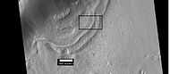
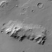
Context for the next image of the end of a flow feature or glacier. Location is Hellas quadrangle.
-
Close-up of the area in the box in the previous image. This may be called by some the terminal moraine of a glacier. For scale, the box shows the approximate size of a football field. Image taken with HiRISE under the HiWish program. Location is Hellas quadrangle.
-
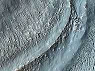
Material Flowing through a crater rim, as seen by HiRISE, under the HiWish program. Lateral moraines are labeled.
-
Glaciers, as seen by HiRISE, under HiWish program. Glacier on left is thin because it has lost much of its ice. Glacier on the right, on the other hand, is thick; it still contains a lot of ice that is under a thin layer of dirt and rock.
-

Tongue-shaped glacier, as seen by HiRISE under the HiWish program. Ice may exist in the glacier, even today, beneath an insulating layer of dirt.
-

Close-up of tongue-shaped glacier, as seen by HiRISE under the HiWish program. Resolution is about 1 meter, so one can see objects a few meters across in this image. Ice may exist in the glacier, even today, beneath an insulating layer of dirt.
Channels
-
Mad Vallis, as seen by HiRISE. Picture on right is an enlargement of part of the other picture.
-
Channels, as seen by HiRISE under HiWish program.
Additional Images
-

thumb|Hellas quadrangle map showing two large river valleys that slope left, toward the floor of the crater.
-

Banded or taffy-pull terrain in Hellas, as seen by Mars Global Surveyor. Origin is unknown at present.
-

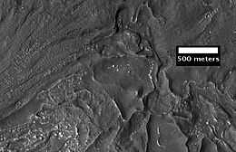
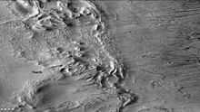
Centauri Montes, as seen by HiRISE. Scale bar is 500 meters long. The original enlargement of the image at the left is full of rich detail on all parts of the picture.
-
Ausonia Mensa, as seen by MGS, under the MOC Public Targeting Program. This eroded mensa has many channels.
-
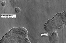
Stages in scalop formation, as seen by HiRISE.
-

Layered feature of unknown origin, as seen by HiRISE under HiWish program.
See also
- Climate of Mars
- Geology of Mars
- Glacier
- Glaciers on Mars
- Impact crater
- List of quadrangles on Mars
- Lobate Debris Apron
- Pedestal crater
- Scalloped topography
- Vallis
- Water on Mars
| Wikimedia Commons has media related to Hellas quadrangle. |
References
- ↑ Davies, M.E.; Batson, R.M.; Wu, S.S.C. (1992). "Geodesy and Cartography". In Kieffer, H.H.; Jakosky, B.M.; Snyder, C.W. et al. Mars. Tucson: University of Arizona Press. ISBN 978-0-8165-1257-7.
- ↑ 2.0 2.1 2.2 2.3 Carr, Michael H. (2006). The Surface of Mars. Cambridge University Press. p. . ISBN 978-0-521-87201-0.
- ↑ 3.0 3.1 Moore, J; Wilhelms, Don E. (2001). "Hellas as a possible site of ancient ice-covered lakes on Mars". Icarus 154 (2): 258–276. Bibcode:2001Icar..154..258M. doi:10.1006/icar.2001.6736.
- ↑ Cabrol, N. and E. Grim (eds). 2010. Lakes on Mars
- ↑ Martian Weather Observation MGS radio science measured 11.50 mbar at 34.4° S 59.6° E -7152 meters.
- ↑ http://hirise.lpl.arizonai.edu/P/sP_008559_1405
- ↑ Kargel, J.; Strom, R. (1991). "Terrestrial glacial eskers: analogs for martian sinuous ridges" (PDF). LPSC XXII: 683–684. Bibcode:1991LPI....22..683K.
- ↑ Head, JW; Neukum, G; Jaumann, R; Hiesinger, H; Hauber, E; Carr, M; Masson, P; Foing, B et al. (2005). "Tropical to mid-latitude snow and ice accumulation, flow and glaciation on Mars". Nature 434 (7031): 346–350. Bibcode:2005Natur.434..346H. doi:10.1038/nature03359. PMID 15772652.
- ↑ http://www.marstoday.com/news/viewpr.html?pid=18050
- ↑ http://news.brown.edu/pressreleases/2008/04/martian-glaciers
- ↑ Plaut, Jeffrey J.; Safaeinili, Ali; Holt, John W.; Phillips, Roger J.; Head, James W.; Seu, Roberto; Putzig, Nathaniel E.; Frigeri, Alessandro (2009). "Radar Evidence for Ice in Lobate Debris Aprons in the Mid-Northern Latitudes of Mars" (PDF). Geophysical Research Letters 36 (2): n/a. Bibcode:2009GeoRL..3602203P. doi:10.1029/2008GL036379.
- ↑ Holt, J.W.; Safaeinili, A.; Plaut, J. J.; Young, D. A.; Head, J. W.; Phillips, R. J.; Campbell, B. A.; Carter, L. M.; Gim, Y.; Seu, R.; Sharad Team et al. (2008). "Radar Sounding Evidence for Ice within Lobate Debris Aprons near Hellas Basin, Mid-Southern Latitudes of Mars" (PDF). Lunar and Planetary Science. XXXIX: 2441. Bibcode:2008LPI....39.2441H.
- ↑ Holt, J. W.; Safaeinili, A.; Plaut, J. J.; Head, J. W.; Phillips, R. J.; Seu, R.; Kempf, S. D.; Choudhary, P. et al. (2008). "Radar Sounding Evidence for Buried Glaciers in the Southern Mid-Latitudes of Mars". Science 322 (5905): 1235–8. Bibcode:2008Sci...322.1235H. doi:10.1126/science.1164246. PMID 19023078.
- ↑ http://themis.asu.edu/zoom-20021022a
- ↑ MLA NASA/Jet Propulsion Laboratory (December 18, 2003). "Mars May Be Emerging From An Ice Age". ScienceDaily. Retrieved February 19, 2009.
- ↑ Touma J. and J. Wisdom. 1993. The Chaotic Obliquity of Mars. Science 259, 1294-1297.
- ↑ Laskar, J., A. Correia, M. Gastineau, F. Joutel, B. Levrard, and P. Robutel. 2004. Long term evolution and chaotic diffusion of the insolation quantities of Mars. Icarus 170, 343-364.
- ↑ Levy, J., J. Head, D. Marchant, D. Kowalewski. 2008. Identification of sublimation-type thermal contraction crack polygons at the proposed NASA Phoenix landing site: Implications for substrate properties and climate-driven morphological evolution. Geophys. Res. Lett. 35. doi:10.1029/2007GL032813.
- ↑ Levy, J., J. Head, D. Marchant. 2009a. Thermal contraction crack polygons on Mars: Classification, distribution, and climate implications from HiRISE observations. J. Geophys. Res. 114. doi:10.1029/2008JE003273.
- ↑ Hauber, E., D. Reiss, M. Ulrich, F. Preusker, F. Trauthan, M. Zanetti, H. Hiesinger, R. Jaumann, L. Johansson, A. Johnsson, S. Van Gaselt, M. Olvmo. 2011. Landscape evolution in Martian mid-latitude regions: insights from analogous periglacial landforms in Svalbard. In: Balme, M., A. Bargery, C. Gallagher, S. Guta (eds). Martian Geomorphology. Geological Society, London. Special Publications: 356. 111-131
- ↑ Laskar, J., A. Correia, M. Gastineau, F. Joutel, B. Levrard, and P. Robutel. 2004. Long term evolution and chaotic diffusion of the insolation quantities of Mars. Icarus 170, 343-364.
- ↑ 22.0 22.1 Mellon, M., B. Jakosky. 1995. The distribution and behavior of Martian ground ice during past and present epochs. J. Geophys. Res. 100, 11781–11799.
- ↑ Schorghofer, N., 2007. Dynamics of ice ages on Mars. Nature 449, 192–194.
- ↑ Madeleine, J., F. Forget, J. Head, B. Levrard, F. Montmessin. 2007. Exploring the northern mid-latitude glaciation with a general circulation model. In: Seventh International Conference on Mars. Abstract 3096.
- ↑ http://themis.asu.edu/zoom-20020807a
- ↑ http://marsrovers.jpl.nasa.gov/gallery/press/spirit/20070412a.html
- ↑ http://mars.jpl.nasa.gov/spotlight/KenEdgett.html
- ↑ Reiss, D. et al. 2011. Multitemporal observations of identical active dust devils on Mars with High Resolution Stereo Camera (HRSC) and Mars Orbiter Camera (MOC). Icarus. 215:358-369.
- ↑ Malin, M. C.; Edgett, K. S.; Posiolova, L. V.; McColley, S. M.; Dobrea, E. Z. N. (2006). "Present-Day Impact Cratering Rate and Contemporary Gully Activity on Mars". Science 314 (5805): 1573–1577. Bibcode:2006Sci...314.1573M. doi:10.1126/science.1135156. PMID 17158321.
- ↑ McEwen, AS; Hansen, CJ; Delamere, WA; Eliason, EM; Herkenhoff, KE; Keszthelyi, L; Gulick, VC; Kirk, RL et al. (2007). "A Closer Look at Water-Related Geologic Activity on Mars". Science 317 (5845): 1706–1709. Bibcode:2007Sci...317.1706M. doi:10.1126/science.1143987. PMID 17885125.
- ↑ http://www.lpi.usra.edu/publications/slidesets/stones/
- ↑ Kieffer, Hugh H. (1992). Mars. Tucson: University of Arizona Press. pp. . ISBN 0-8165-1257-4.

| Quadrangles on Mars | |||||||||||||||||||||||
|---|---|---|---|---|---|---|---|---|---|---|---|---|---|---|---|---|---|---|---|---|---|---|---|
| MC-01 Mare Boreum (features) | |||||||||||||||||||||||
| MC-05 Ismenius Lacus (features) |
MC-06 Casius (features) |
MC-07 Cebrenia (features) |
MC-02 Diacria (features) |
MC-03 Arcadia (features) |
MC-04 Acidalium (features) | ||||||||||||||||||
| MC-12 Arabia (features) |
MC-13 Syrtis Major (features) |
MC-14 Amenthes (features) |
MC-15 Elysium (features) |
MC-08 Amazonis (features) |
MC-09 Tharsis (features) |
MC-10 Lunae Palus (features) |
MC-11 Oxia Palus (features) | ||||||||||||||||
| MC-20 Sinus Sabaeus (features) |
MC-21 Iapygia (features) |
MC-22 Mare Tyrrhenum (features) |
MC-23 Aeolis (features) |
MC-16 Memnonia (features) |
MC-17 Phoenicis Lacus (features) |
MC-18 Coprates (features) |
MC-19 Margaritifer Sinus (features) | ||||||||||||||||
| MC-27 Noachis (features) |
MC-28 Hellas (features) |
MC-29 Eridania (features) |
MC-24 Phaethontis (features) |
MC-25 Thaumasia (features) |
MC-26 Argyre (features) | ||||||||||||||||||
| MC-30 Mare Australe (features) | |||||||||||||||||||||||