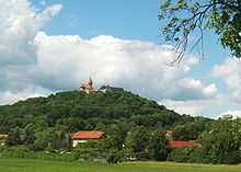
Heldburger Gangschar
The Heldburger Gangschar is a Cenozoic volcanic system in the Franconian parts of southern Thuringia and northern Bavaria. The term Gangschar refers to the fact that few of the volcanoes are still preserved as surface shape, while their former activity can be detected by “passage” called fissure fillings. These courses are mostly trained in south-south-west direction, their cross-section is often less than one meter. It is named after the small town Heldburg situated in the Bad Colberg-Heldburg municipality. Their surroundings, the Heldburger Land, completely belongs to the northern part of the volcanic zone. The most impressive by far the still preserved volcanic cones represent the 641 m and 679 m high Gleichberge situated nearby Heldburger Land.
Location


The Heldburger Gangschar is not a self-contained landscape and is distributed mainly on the main physiographic units Grabfeld, Itz- Baunach Hügelland and Haßberge. South of the river Main but their former activity is also detectable in the respective northern Steigerwald and Fränkische Alb. Your core zone extends from Hildburghausen to Gerolzhofen.
Volcanic cone
The following are the most famous preserved volcanic cones in parentheses their altitude, and their approximate age and their rock:
- Großer Gleichberg ( 679 meters, 15 million years Alkaliolivinbasalt ) — situated in Grabfeld
- Kleiner Gleichberg ( 641 m ) — situated in Grabfeld
- Bramberg (495 meters, 15 million years, Alkaliolivinbasalt ) — situated in Hassberge
- Zeilberg ( 463 m, 16 million years, Nephelinbasanit ) — situated in Itz-Baunach-Hügelland
- Straufhain ( 449 m ) - situated in Itz- Baunach-Hügelland — Heldburger Land
- Veste Heldburg(mountain) (405 meters, 12 million years, phonolite Olivintephritgang ) — situated in Itz-Baunach Hügelland - Heldburger Land
Older volcanoes such as the volcano of Oberleinleiter in the Fränkische Alb ( 31 million years, Olivinmelilithnephelinith and Olivinnephelinit ) are no longer recognizable as surface shape today. Although it is the latter reaches a height of 505 m, however, is completely sunk into the Jurassic rocks of the Alps.
Literature
- Gerd Geyer, Hermann Schmidt-Kaler: Coburger Land und Heldburger Gangschar: Wanderungen in die Erdgeschichte; Verlaf Pfeil; ISBN 978-3899370683
- Norbert Klaus Fuchs: Das Heldburger Land – ein historischer Reiseführer. Verlag Rockstuhl, Bad Langensalza 2013, ISBN 978-3-86777-349-2.