Heilongjiang
| Heilongjiang Province 黑龙江省 | |
|---|---|
| Province | |
| Name transcription(s) | |
| • Chinese | 黑龙江省 (Hēilóngjiāng Shěng) |
| • Abbreviation | 黑 (pinyin: Hēi) |
.svg.png) Map showing the location of Heilongjiang Province | |
| Coordinates: 48°N 129°E / 48°N 129°ECoordinates: 48°N 129°E / 48°N 129°E | |
| Named for |
黑 hēi—black 龙 lóng—dragon 江 jiāng—river "Amur River" |
| Capital (and largest city) | Harbin |
| Divisions | 13 prefectures, 130 counties, 1274 townships |
| Government | |
| • Secretary | Wang Xiankui |
| • Governor | Lu Hao |
| Area[1] | |
| • Total | 454,800 km2 (175,600 sq mi) |
| Area rank | 6th |
| Population (2010)[2] | |
| • Total | 38,312,224 |
| • Rank | 15th |
| • Density | 84/km2 (220/sq mi) |
| • Density rank | 28th |
| Demographics | |
| • Ethnic composition |
Han: 95% Manchu: 3% Korean: 1% Mongol: 0.4% Hui: 0.3% |
| • Languages and dialects | Northeastern Mandarin, Jilu Mandarin, Jiaoliao Mandarin |
| ISO 3166 code | CN-23 |
| GDP (2014) |
CNY 1.504 trillion US$ 244.8 billion (16th) |
| - per capita |
CNY 39,164 US$ 6,375 (16th) |
| HDI (2010) | 0.704[3] (high) (12th) |
| Website |
www |
| Heilongjiang | |||||||||||||
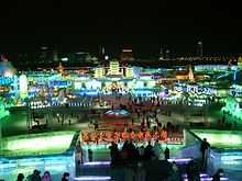 Winter night in Harbin's Ice and Snow World | |||||||||||||
| Chinese name | |||||||||||||
|---|---|---|---|---|---|---|---|---|---|---|---|---|---|
| Simplified Chinese | 黑龙江 | ||||||||||||
| Traditional Chinese | 黑龍江 | ||||||||||||
| Postal Map | Heilungkiang | ||||||||||||
| Literal meaning | Black Dragon River | ||||||||||||
| |||||||||||||
| Mongolian name | |||||||||||||
| Mongolian | Qaramörin | ||||||||||||
| Manchu name | |||||||||||||
| Manchu script | ᠰᠠᡥᠠᠯᡳᠶᠠᠨ ᡠᠯᠠ | ||||||||||||
| History of the Priamurye region (also including Heilongjiang, Amur Oblast and southern part of Khabarovsk Krai) |
|---|
| Sushen |
| Mohe • Shiwei |
| Balhae |
| Khitan |
| Liao dynasty • Daurs |
| Jin dynasty (1115–1234) • Nivkh |
| Eastern Jin (1215–1234) |
| Yuan dynasty • Evenks |
| Yeren Jurchens • Solon Khanate |
| Qing dynasty • Nanais • Ulchs |
| Russian Exploration • Negidals |
| Manchus–Cossacks wars (1652–1689) |
| Nerchinsk |
| Government-General of Eastern Siberia |
| Aigun |
| Li–Lobanov Treaty |
| Siberian Regional Government |
| Far Eastern Republic |
| Far Eastern Oblast |
| Soviet invasion of Manchuria (1945) |
| Sino-Soviet border conflict |
| Far Eastern Federal District |
Heilongjiang (Chinese: 黑龙江; pinyin: ![]() Hēilóngjiāng ) is a province of the People's Republic of China located in the northeastern part of the country. "Heilongjiang" literally means Black Dragon River, which is the Chinese name for the Amur. The one-character abbreviation is 黑 (pinyin: Hēi). The Manchu name of the region is Sahaliyan ula ᠰᠠᡥᠠᠯᡳᠶᠠᠨ ᡠᠯᠠ (literally, "Black River"), from which the name of Sakhalin is derived, and the Mongolian name accordingly is Qaramörin.
Hēilóngjiāng ) is a province of the People's Republic of China located in the northeastern part of the country. "Heilongjiang" literally means Black Dragon River, which is the Chinese name for the Amur. The one-character abbreviation is 黑 (pinyin: Hēi). The Manchu name of the region is Sahaliyan ula ᠰᠠᡥᠠᠯᡳᠶᠠᠨ ᡠᠯᠠ (literally, "Black River"), from which the name of Sakhalin is derived, and the Mongolian name accordingly is Qaramörin.
Heilongjiang borders Jilin in the south and Inner Mongolia to the west; it also borders Russia to the north and east.
The Amur River marks the border between the People's Republic of China and Russia to the north. Heilongjiang contains China's northernmost point (in Mohe County along the Amur) and easternmost point (at the junction of the Amur and Ussuri Rivers).
History
In ancient times Heilongjiang was far from any literate civilization, and information was sparse. Ancient Chinese records and other sources state that Heilongjiang was inhabited by people such as the Buyeo, the Mohe, and the Khitan. Mongolic Donghu people lived in Inner Mongolia and the western part of Heilongjiang.[4] Some names are Manchu or Mongolian.[5] The eastern portion of Heilongjiang was ruled by the kingdom of Balhae between the 7th century and 10th century. The Jurchen Jin Dynasty (1115–1234) that subsequently ruled much of north China arose within the borders of modern Heilongjiang.

Heilongjiang as an administrative entity was created in 1683, during the Kangxi era of the Manchu Qing Dynasty, from the northwestern part of the Jilin province.[6] This Heilongjiang Province only included the western part of today's Heilongjiang Province, and was under the supervision of the General of Heilongjiang (the title is also translated as the Military Governor of Heilongjiang), whose power extended, according to the Treaty of Nerchinsk, as far north as the Stanovoy Mountains. The eastern part of what's today Heilongjiang remained under the supervision of the General of Jilin, whose power reached the Sea of Japan. These areas deep in Manchuria were closed off to Han Chinese migration.
The original seat of the Military Governor of Heilongjiang, as established in 1683, was in Heilongjang City (also known as Aigun or Heihe, or, in Manchu, Saghalien Ula), located on the Amur River. However, already in 1690 the seat of the governor was transferred to Nenjiang (Mergen) on the Nen River, and, in 1699, further south to Qiqihar. According to modern historians, the moves may have been driven by supply considerations: Nenjiang and Qiqihar are connected by a convenient waterway (Nen River) with southern Manchuria, meanwhile accessing Aigun (Heihe) would require either sailing all the way down the Sungari River until its fall into Amur and then up the Amur to Heihe, or using a portage over the Lesser Xing'an Mountains between the Nen River valley and the Amur valley. An additional advantage of Qiqihar may have been its location at the junction of a northbound road (to Nenjiang) and a westbound one (to Mongolia), enabling its garrison to serve for the defense both against the Russians and the Ölöt Mongols.[7]
In 1858 and 1860 the Qing government was forced to give up all land beyond the Amur and Ussuri Rivers to the Russian Empire, cutting off the Qing Empire from the Sea of Japan and giving Heilongjiang its present northern borders. At the same time, Manchuria was opened to Han Chinese migration by the Qing government. By the early twentieth century, due to the Chuang Guandong, the Han Chinese had become the dominant ethnic group in the region.[8]
In 1932, present-day Heilongjiang became part of the Japanese puppet state of Manchukuo.
In 1945, the Japanese were defeated by the Soviet Army. During the Chinese Civil War Heilongjiang became the first province to be completely controlled by the Chinese communists and Harbin the first major city to be controlled by them.
At the beginning of communist rule, Heilongjiang included only the western portion of the present-day province, and had its capital at Qiqihar. The remaining area was the province of Songjiang; its capital was Harbin. In 1954, these two provinces were merged into present-day Heilongjiang. During the Cultural Revolution, Heilongjiang was also expanded to include Hulunbuir League and some other areas previously in Inner Mongolia; this has since mostly been reversed.
Geography
Heilongjiang is a land of varied topography. Much of the province is dominated by mountain ranges such as the Greater Khingan Range and Lesser Khingan Range, Zhangguangcai Mountains, Laoye Mountains, and Wanda Mountains. The highest peak is Mount Datudingzi at 1,690 metres (5,540 ft), located on the border with Jilin province). The Greater Khingan Range contains China's largest remaining virgin forest and is an important area for China's forestry industry.
The interior of the province, which is relatively flat and low in altitude, contains the Muling River, the Naoli River, the Songhua River, the Nen River, and the Mudan River, all tributaries of the Amur's basin, while the northern border forms part of the Amur valley. Xingkai Lake (or Khanka Lake) is found on the border with Russia's Primorsky Krai.
A humid continental climate (Köppen Dwa or Dwb) predominates in the province, though areas in the far north are subarctic (Köppen Dwc).[9] Winters are long and bitter, with an average of −31 to −15 °C (−24 to 5 °F) in January, and summers are short and warm to very warm with an average of 18 to 23 °C (64 to 73 °F) in July. The annual average rainfall is 400 to 700 millimetres (16 to 28 in), concentrated heavily in summer. Clear weather is prevalent throughout the year, and in the spring, the Songnen Plain and the Sanpingjiang Plain provide abundant sources of wind energy.
Major cities: Harbin, Daqing, Qiqihar, Mudanjiang, Jiamusi, Jixi, Shuangyashan, Hegang, Qitaihe, Yichun, Heihe
Transport
A road and highway proposal was accepted in 2006; the project plans to develop 38,000 kilometers of new roads and expand Heilongjiang’s total road network to 2.3 million kilometers.
There are 60 rail lines of around 5,300 kilometers including a section of the Asia-Europe Continental Bridge. Construction of a RMB92.3 billion passenger-only railway line running from Harbin-Dalian began in August 2007. The railway will stretch from Harbin, Heilongjiang’s capital, to Dalian in Liaoning province via Changchun and Shenyang comprising 23 stops. It is expected to transport 37 million passengers per year by 2020 and 51 million by 2030. Major airports include Harbin International Airport, Qiqihar Airport, Mudanjiang Airport, Jiamusi Airport and Heihe Airport. Harbin International Airport is capable of handling six million passengers every year and connects to over 40 domestic and international cities.
Administrative divisions
Heilongjiang is divided into thirteen prefecture-level divisions: twelve prefecture-level cities (including a sub-provincial city) and one prefecture:
| Map | # | Name | Administrative Seat | Chinese Hanyu Pinyin |
Population (2010) |
|---|---|---|---|---|---|
 | |||||
| — Sub-provincial city — | |||||
| 1 | Harbin (Provincial seat) |
Nangang District | 哈尔滨市 Hā'ěrbīn Shì |
10,635,971 | |
| — Prefecture-level city — | |||||
| 2 | Qiqihar | Longsha District | 齐齐哈尔市 Qíqíhā'ěr Shì |
5,367,003 | |
| 3 | Mudanjiang | Aimin District | 牡丹江市 Mǔdānjiāng Shì |
2,798,723 | |
| 4 | Jiamusi | Qianjin District | 佳木斯市 Jiāmùsī Shì |
2,552,097 | |
| 5 | Daqing | Sartu District | 大庆市 Dàqìng Shì |
2,904,532 | |
| 6 | Jixi | Jiguan District | 鸡西市 Jīxī Shì |
1,862,161 | |
| 7 | Shuangyashan | Jianshan District | 双鸭山市 Shuāngyāshān Shì |
1,462,626 | |
| 8 | Yichun | Yichun District | 伊春市 Yīchūn Shì |
1,148,126 | |
| 9 | Qitaihe | Taoshan District | 七台河市 Qītáihé Shì |
920,419 | |
| 10 | Hegang | Xingshan District | 鹤岗市 Hègǎng Shì |
1,058,665 | |
| 11 | Heihe | Aihui District | 黑河市 Hēihé Shì |
1,673,898 | |
| 12 | Suihua | Beilin District | 绥化市 Suíhuà Shì |
5,416,439 | |
| — Prefecture — | |||||
| 13 | Da Hinggan Ling | Jiagedaqi District | 大兴安岭地区 Dàxīng'ānlǐng Dìqū |
511,564 | |


(Additional information regarding the last prefecture can be found in Greater Khingan)
The thirteen prefecture-level divisions of Heilongjiang are subdivided into 130 county-level divisions (65 districts, nineteen county-level cities, forty-five counties, and one autonomous county). Those are in turn divided into 1284 township-level divisions (473 towns, 400 townships, 58 ethnic townships, and 353 subdistricts).
Politics
List of Secretaries of the CPC Heilongjiang Committee:
- Zhang Qilong 张启龙(1949–1950)
- Zhao Dezun 赵德尊 (1950–1953)
- Feng Jixin 冯纪新 (1953–1954)
- Ouyang Qin 欧阳钦 (1954–1965)
- Pan Fusheng 潘复生 (1965–1971)
- Wang Jiadao 汪家道 (1971–1974)
- Liu Guangtao 刘光涛 (1977)
- Yang Yichen 杨易辰 (1977–1983)
- Li Li'an 李力安 (1983–1985)
- Sun Weiben 孙维本 (1985–1994)
- Yue Qifeng 岳岐峰 (1994–1997)
- Xu Youfang 徐有芳 (1997–2003)
- Song Fatang 宋法棠 (2003–2005)
- Qian Yunlu 钱运录 (2005–2008)
- Ji Bingxuan 吉炳轩 (2008–2013)
- Wang Xiankui 王宪魁 (March 2013 – incumbent)
List of Governors:
- Yu Yifu 于毅夫 (1949–1952)
- Zhao Dezun 赵德尊 (1952–1953)
- Chen Lei 陈雷 (1953–1954)
- Han Guang 韩光 (1954–1956)
- Ouyang Qin 欧阳钦 (1956–1958)
- Li Fanwu 李范五 (1958–1966)
- Pan Fusheng 潘复生 (1967–1971)
- Wang Jiadao 汪家道 (1971–1974)
- Liu Guangtao 刘光涛 (February 1977 – December 1977)
- Yang Yichen 杨易辰(December 1977 – 1979)
- Chen Lei 陈雷 (1979–1985)
- Hou Jie 侯捷 (1985–1989)
- Shao Qihui 邵奇惠 (1989–1994)
- Tian Fengshan 田凤山(1994–2000)
- Song Fatang 宋法棠 (2000–2003)
- Zhang Zuoji 张左己 (2003 – December 2007)
- Li Zhanshu 栗战书 (December 2007 – August 2010)
- Wang Xiankui 王宪魁 (August 2010 – March 2013)
- Lu Hao 陆昊 (March 2013 – incumbent)
Economy
The agriculture of Heilongjiang, heavily defined by its cold climate, is based upon crops such as soybeans, maize, and wheat. Commercial crops grown include beets, flax, and sunflowers.
Heilongjiang is also an important source of lumber for China. Pine, especially the Korean pine and larch are the most important forms of lumber produced in Heilongjiang. Forests are mostly to be found in the Daxingan Mountains and Xiaoxingan Mountains, which are also home to protected animal species such as the Siberian Tiger, the red-crowned crane, and the lynx.
Herding in Heilongjiang is centered upon horses and cattle; the province has the largest number of milk cows and the highest production of milk among all the province-level divisions of China.
Petroleum is of great importance in Heilongjiang, and the Daqing oilfields are an important source of petroleum for China. Coal, gold, and graphite are other important minerals to be found in Heilongjiang. Heilongjiang also has great potential for wind power, with an average wind energy density of 200 watts per square metre.
Heilongjiang is part of northeast China, the country's traditional industrial base. Industry is focused upon coal, petroleum, lumber, machinery, and food. Due to its location, Heilongjiang is also an important gateway for trade with Russia. In recent years, Manchuria has suffered from stagnation. As a result, the government has started the Revitalize Northeast China campaign to deal with this problem, using privatization as the preferred method of economic reform.
At least five miners were killed after a coal mine fire in Heilongjiang it was reported on September 21, 2008.[10]
Its GDP has been rising steadily since 2003, growing 37% from 2003 to 2007. Furthermore, the incremental value of the private economy grew by 20.1 percent in 2006 reaching RMB234 billion, and accounting for 37.6 percent of the GDP. The tax revenue from private enterprises hit RMB20.5 billion, a rise of 17.8 percent.
Private enterprises in Heilongjiang witnessed the fastest development in 2007, fueling the overall economic growth of the province. Many leading private enterprises have begun to emerge. Over 200 of them have an annual income exceeding RMB100 million. The province's three major private enterprises, namely the Heilongjiang Sunflower Medicine Ltd, Qitaihe Yidaxin Coal Co., and Heilongjiang Yiyang Group, each contributed more than RMB100 million in tax revenue in 2007.
At present, many private investors are involved in large construction projects in Heilongjiang. In 2006, 928 large projects absorbed private capital of RMB5 million each, and 101 projects attracted RMB100 million each within the province. In line with the central government’s policy to revitalize the Northeast, Heilongjiang is now restructuring its six pillar industries, namely equipment manufacturing, petrochemicals, food processing, energy, pharmaceuticals, and forest and timber processing.
In 2011, Heilongjiang's nominal GDP was 1,250 billion yuan (US$198.5 billion), an annual growth rate of 12.2%. Its per capita GDP was 21,640 yuan (US$3,168). Its primary, secondary, and tertiary industries were worth 108.9 billion yuan, 436.6 billion yuan, and 285.5 billion yuan respectively.[11] The per capita disposable income of urban residents in Heilongjiang reached 11,581 yuan (US$1,667), a rise of 13% from the previous year. The per capita net income of rural residents in the province reached 4,856 yuan (US$700), a rise of 17.5 from 2007.[12]
Economic and technological development zones
- Daqing New & Hi-Tech Industrial Development Zone
- Daqing New & Hi-Tech Industrial Development Zone was constructed in April 1992 and was then approved as a national high-tech zone by the State Council later that year. Its initial zone area is 208.54 km2, and it recently expanded the area by 32.45 km2.[13]
- Heihe Border Economic Cooperation Area
- Harbin Economic and Technological Development Zone
- Harbin New & Hi-Tech Industrial Development Zone
- Harbin High-tech Zone was set up in 1988 and was approved by the State Council as a national development zone in 1991. It has a total area of 34 km2 in the centralized parks, subdivided into Nangang, Haping Road and Yingbin Road Centralized Parks. The Nangang Centralized Park is designated for the incubation of high-tech projects and research and development base of enterprises as well as tertiary industries such as finance, insurance, services, catering, tourism, culture, recreation and entertainment, where the headquarters of major well-known companies and their branches in Harbin are located; the Haping Road Centralized Park is a comprehensive industrial basis for the investment projects of automobile and automobile parts manufacturing, medicines, foodstuffs, electronics, textile; the Yingbin Road Centralized Park is mainly for high-tech incubation projects, high-tech industrial development.[14]
- Sino-Russia Dongning-Piurtaphca Trade Zone
- Sino-Russia Dongning-Piurtaphca Trade Zone was approved by the State Council in 2000 and was completed in 2005. The zone has a planned area of 275.4 hectare. The Chinese part of the zone has a 22-hectare trade center with 4 subsidiary area A, B, C, D. in which more than 6,000 stalls are already set up, mainly dealing with clothes, household appliances, food, construction materials, etc.[15]
- Suifenhe Border Economic Cooperation Area
- Suifenhe Border Economic Cooperation District (Suifenhe BECD) is located in the north of Suifenhe City, and borders Russia to the east. Suifenhe BECD is the largest among the three state-level border-trade zones of Heilongjiang, in terms of investor numbers. Suifenhe BECD has a convenient transport network. The Binzhou-Suifenhe Railway, which connects the Russian Far East Railway, is an important port for export. The railway distance between Suifenhe and Harbin is 548 km (341 mi). Buguranikinai, the corresponding Russian port city, is 21 km (13 mi) away.[16]
Demographics
The majority of Heilongjiang's population is Han Chinese, while other ethnic minorities include the Manchus, Koreans, Mongols, Hui, Daur, Xibe, Oroqin, Hezhen and Russians.
| Ethnic groups in Heilongjiang (2000 census) | ||
|---|---|---|
| Nationality | Population | Percentage |
| Han Chinese | 34,465,039 | 95.20% |
| Manchu | 1,037,080 | 2.86% |
| Koreans | 388,458 | 1.07% |
| Mongol | 141,495 | 0.39% |
| Hui | 124,003 | 0.34% |
| Daur | 43,608 | 0.12% |
| Xibe | 8,886 | 0.03% |
Excludes members of the People's Liberation Army in active service.
Source: Department of Population, Social, Science and Technology Statistics of the National Bureau of Statistics of China (国家统计局人口和社会科技统计司) and Department of Economic Development of the State Ethnic Affairs Commission of China (国家民族事务委员会经济发展司), eds. Tabulation on Nationalities of 2000 Population Census of China (《2000年人口普查中国民族人口资料》). 2 vols. Beijing: Nationalities Publishing House (民族出版社), 2003. (ISBN 7-105-05425-5)
Religion
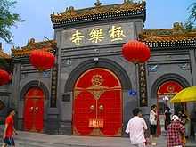
Most Heilongjiang's residents are either non-religious or practice Chinese folk religions, including Taoism. Manchu shamanism is practiced by many Manchu people. Chinese Buddhism and Tibetan Buddhism have an important presence in the province.
Culture
Heilongjiang's culture is part of a culture of Northeast China that is relatively homogeneous across this region, known in Mandarin Chinese as "Dongbei" (the northeast).
Media
Heilongjiang Television and Harbin Economy Radio serve as broadcasters.
Tourism
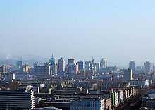
Harbin, the provincial capital, is a city of contrasts, with Chinese, Russian, and eclectic worldwide influences clearly apparent. Bukui Mosque, a national heritage site, is the largest glazed tile building in the province.[17] Eastern Orthodox, Roman Catholic, and Protestant churches as well as synagogues dot the city.[18]
The long, cold winter is the backdrop for its famed ice sculpture exhibitions. In 2007 already the 8th Ice and Snow World opened to visitors in Harbin. More than 2000 ice sculptures were on display at the annual event.[19]
Wudalianchi Lakes are a series of five lakes formed between 1719 and 1721 when volcanic eruption shaped one section of a tributary of the Amur into five interconnected lakes. The second lake in particular is renowned for its irregular geological sights.
Lake Jingbo, in Ning'an County, is a section of the Mudan River that has been narrowed and shaped by volcanic eruption into a series of sights, including the Diaoshuilou Falls.
Colleges and universities
- Northeast Forestry University
- Harbin Institute of Technology
- Harbin Engineering University
- Northeast Agricultural University
- Harbin University of Science and Technology
- Heilongjiang University
- Heilongjiang Institute of Technology
- Harbin Medical University
- Daqing Staff and Workers University
- Daqing Petroleum Institute
- Heilongjiang University of Traditional Chinese Medicine
- Heilongjiang Commercial University
- Harbin Normal University
- Heilongjiang August First Land Reclamation University
- Qiqihar University
Sports
See also
References
- ↑ "Doing Business in China – Survey". Ministry Of Commerce – People's Republic Of China. Retrieved 5 August 2013.
- ↑ "Communiqué of the National Bureau of Statistics of People's Republic of China on Major Figures of the 2010 Population Census [1] (No. 2)". National Bureau of Statistics of China. 29 April 2011. Retrieved 4 August 2013.
- ↑ 《2013中国人类发展报告》 (PDF) (in Chinese). United Nations Development Programme China. 2013. Retrieved 2014-01-05.
- ↑ Origins of Minority Ethnic Groups in Heilongjiang
- ↑ 浅谈黑龙江省地名的特点
- ↑ Edmonds, Richard Louis (1985). Northern Frontiers of Qing China and Tokugawa Japan: A Comparative Study of Frontier Policy. University of Chicago, Department of Geography; Research Paper No. 213. p. 6. ISBN 0-89065-118-3.
- ↑ Edmonds (1985), pp. 115–117
- ↑ Patrick Fuliang Shan, "Taming China's Wilderness: Immigration, Settlement, and the Shaping of the Heilongjiang Frontier, 1900–1931," Ashgate, 2014, ISBN 978-1-4094-6389-4
- ↑ Updated Asian map of the Köppen climate classification system
- ↑ "50 dead in Chinese mining accidents." CNN. Retrieved on December 27, 2008.
- ↑ NE China province reports record GDP growth
- ↑ 2006年黑龙江省农民人均收入达3552元 增长10.3%
- ↑ RightSite.asia | Daqing New & Hi-Tech Industrial Development Zone
- ↑ RightSite.asia | Harbin New & Hi-Tech Industrial Zone
- ↑ RightSite.asia | Sino-Russia Dongning-Piurtaphca Trade Zone
- ↑ RightSite.asia | Suifenhe Border Economic Cooperation District
- ↑ Bukui Mosque, a popular tourist attraction
- ↑ "China Expat city Guide". China Expat. 2008. Retrieved 2009-02-08.
- ↑ Ice and Snow Festival in Harbin
External links
| Wikimedia Commons has media related to Heilongjiang. |
- Heilongjiang Government website
 Heilongjiang travel guide from Wikivoyage
 |
|
|
|
|
| Inner Mongolia | |
|||
| ||||
| | ||||
| Jilin | |
| ||||||||||||||||||||||||||
| ||||||||||||||||||||||||||
| |||||||||||||||||||||||||