Heath Mynd
| Heath Mynd | |
|---|---|
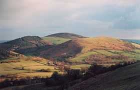 Heath Mynd and Cefn Gunthly, looking south from Mucklewick Hill | |
| Elevation | 452 m (1,483 ft) |
| Prominence | 190 m (620 ft) |
| Parent peak | Corndon Hill |
| Listing | Marilyn |
| Location | |
| Location | Shropshire Hills, England |
| OS grid | SO335940 |
| Topo map | OS Landranger 137 |
Heath Mynd is a hill in the English county of Shropshire. It is fairly unnotable except for its Marilyn status, a feature caused by the sharp drop on all sides. It is connected to Corndon Hill by a low col, and is only just inside England, being just one mile from the border with Wales. The nearby village is Norbury; nearest towns are Bishop's Castle and Church Stretton. Its nearest neighbour (visible in the photo) is called Cefn Gunthly.
Coordinates: 52°32′23″N 2°58′55″W / 52.53978°N 2.98193°W