Heath, Shropshire
| Heath | |
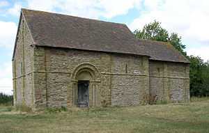 Heath Chapel |
|
 Heath |
|
| OS grid reference | SO5585 |
|---|---|
| Civil parish | Heath |
| Unitary authority | Shropshire |
| Ceremonial county | Shropshire |
| Region | West Midlands |
| Country | England |
| Sovereign state | United Kingdom |
| Post town | BUCKNELL, CRAVEN ARMS, LYDBURY NORTH |
| Postcode district | SY7 |
| Police | West Mercia |
| Fire | Shropshire |
| Ambulance | West Midlands |
| EU Parliament | West Midlands |
| UK Parliament | Ludlow |
|
|
Coordinates: 52°27′58″N 2°39′00″W / 52.466°N 02.65°W
Heath is a hamlet and small civil parish in the Clee Hills area of Shropshire, England.
The settlement and wider rural area historically had a larger population than now, especially in medieval times. Heath Chapel is a Norman Grade I Listed building.[1]
Nearby are the larger settlements of Bouldon and Clee St. Margaret. Heath lies at approximately 240 metres (790 ft) above sea level.[2]
See also
- Deserted medieval village
References
- ↑ Heath Chapel
- ↑ Ordnance Survey mapping