Hawizeh Marshes
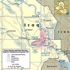
1994 Map of The Mesopotamian Marshes with draining features. Click to expand.
The Hawizeh Marshes are a complex of marshes that straddle the Iraq and Iran border. The marshes are fed by two branches of the Tigris River (the Al-Musharrah and Al-Kahla) in Iraq and Karkheh River in Iran. The Hawizeh marsh is critical to the survival of the Central and Hammar marshes, which also make up the Mesopotamian Marshes, because they are a refuge for species that may recolonize or reproduce into the other marshlands. The Hawizeh Marshes are drained by the Al-Kassarah. This river plays a critical role in maintaining the marshes as a flow-through system and preventing it from becoming a closed saline basin.
See Also
References
External source
31°32′32″N 47°42′24″E / 31.54222°N 47.70667°ECoordinates: 31°32′32″N 47°42′24″E / 31.54222°N 47.70667°E