Haverigg
| Haverigg | |
 Haverigg |
|
| Population | 1,791 (Ward) |
|---|---|
| OS grid reference | SD160787 |
| Civil parish | Millom |
| District | Copeland |
| Shire county | Cumbria |
| Region | North West |
| Country | England |
| Sovereign state | United Kingdom |
| Post town | Millom |
| Postcode district | LA |
| Dialling code | 01229 |
| Police | Cumbria |
| Fire | Cumbria |
| Ambulance | North West |
| EU Parliament | North West England |
| UK Parliament | Copeland |
Coordinates: 54°11′50″N 3°17′21″W / 54.19715°N 3.28906°W
Haverigg, a village on the south-west coast of Cumbria, England, historically part of the county of Cumberland. It is a ward within the civil parish of Millom,[1] and is within the local government district of Copeland. In 2001 it had a population of 1,791 in 548 households.[2]
The name Haverigg derives from the Old Norse and can be translated as ‘the hill where oats are grown’.
Haverigg has an extensive, quiet Blue Flag beach. It also has a restored lighthouse and is close to the Hodbarrow RSPB Nature Reserve on the edge of Hodbarrow Lagoon. Haverigg is at the mouth of the Duddon Estuary, a protected area important for birds and other wildlife.
The village is also home to Haverigg Prison, a low security prison for males from all over the North of England.
An independent lifeboat station, Haverigg Inshore Rescue Team, has been based in the village since 1973 assisting those in difficulty around the Duddon coastline.[3]
Gallery
-
.jpg)
Haverigg Pool
-
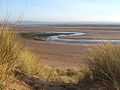
Duddon sands
-
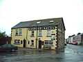
The Harbour Hotel
-

Duddon Estuary and restored lighthouse
-

Horses on the beach
External links
| Wikimedia Commons has media related to Haverigg. |
References
- ↑ "Millom CP". neighourhood Statistics. Office for National Statistics. Retrieved 23 January 2011.
- ↑ "Haverigg (Ward)". Neighbourhood Statistics. Office for National Statistics. Retrieved 23 January 2011.
- ↑ "Haverigg Inshore Rescue". Haverigg Inshore Rescue. Retrieved 6 November 2013.