Havelock North
| Havelock North | ||
|---|---|---|
 Havelock North | ||
| Urban Area | Resident Population | 13,071 (2013 Census)[1] |
| Regional Council |
Hawke's Bay | |
Havelock North is a suburb in Hastings, New Zealand, in the North Island's Hawke's Bay region. It ranked as a borough for many years until the 1989 reorganisation of local government saw it merged into the new Hastings District, and is now administered by the Hastings District Council. Department of Internal Affairs information about the Hastings District Council
Location, features and population
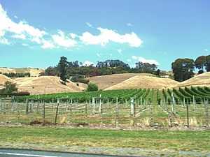
The suburb, known locally as "the village", stands on the Heretaunga Plains, and has a reputation for its orchards, vineyards, and educational facilities. One of New Zealand's most important wine regions spreads around the area. The town's industry is based around its fruit and wine production, and includes a horticultural research centre. The Village is located less than 2 km to the South East of the Districts larger urban centre Hastings founded in 1875. The gap between the two centres often comes under pressure to construct new housing, however the highly valuable and fertile soils that lie between the two centres continue to prevent urban sprawl linking them together. Havelock North itself is primarily residential and Rural-Residential housing, with only a relatively small and compact industrial and commercial centre. As a result a large majority of its 13,000 residents commute each morning to the nearby Hastings or Napier cities for work.
Havelock North is situated at the base of the prominent landmark Te Mata Peak, a 399-metre outcrop, which according to local Māori legend is the body of the giant Te Mata o Rongokako,[2] and the depression in the land visible behind his head according to the myth is where he tried to bite through the mountain range which filled his stomach turning him to stone.[3]
One of the town's most impressive buildings is Whare Ra, a house built for a temple of the Hermetic Order of the Golden Dawn in the early twentieth century.
Havelock North is generally hilly, as it is on the foothills of Te Mata Peak and small gullies have been formed by the creeks and streams flowing from Te Mata Peak, resulting in a small amount of inaccessible or steep land which is converted into forests, parks or reserves, giving the image of naturally having many bushes and trees.
As you enter Havelock North from Hastings you cross a bridge over the Karamu Stream. The deeply incised channel provides a hint that this was once a much larger stream. In the early 1800s this stream was part of the much larger Ngaruroro River system, and was once called the "River Plassey" after one of the early European settlers. Early survey plans of Havelock North show Ferry landings where boats would sail up and down the river to collect and deliver supplies. Unfortunately a number of large floods during the mid 1800s diverted the Ngaruroro River to its current course further north away from Havelock North and is now referred to as the Karamu Stream. During the devastating 1931 earthquake the bridge over the Karamu was completely destroyed, See National Archives Photo 1 and Photo 2 in these photos you can see the towns water main being supported in mid air. Both Hastings and Havelock North obtain very pure water from secure confined aquifer systems. The Te Mata aquifer that feeds Havelock North is very similar to Hastings in quality, but has slightly elevated calcium levels, whereas Hastings is situated directly over the very productive and pure Heretaunga Plains aquifer system (Heretaunga Plains Groundwater Study, Exec Summary - File 500Kb) and (Heretaunga Plains Groundwater Study, Volume 1 - File 9MB). These aquifers are part of the life blood that support the varying Horticulture and Viticulture activities within the region. The mixture of pure water, fertile soils and climate are well known for providing some of the greatest wines, fruits and vegetables in the world!
Areas within Havelock North include Anderson Park, Iona, Havelock North Central, Te Mata and Te Mata Hills, from the census units of Statistics NZ.[4]
History

Havelock North took its name from Sir Henry Havelock, a hero of the Indian Mutiny campaign, thus keeping with the local habit of naming towns after prominent men from Imperial India. Its founders originally envisaged a larger town for the site, but when the Wellington-Napier rail line went through the area in 1874 it took a direct route some distance from Havelock North, and Hastings became a more logical choice for residents
Like a number of North Island towns, Havelock North has grown larger than its South Island namesake, Havelock, in the Marlborough Sounds.
Residents
Notable residents include:
- Alan Duff (born 1950), novelist
- Alfred Meebold (1863–1952), botanist, writer, and anthroposopher (died at Havelock North)
- Dr Robert William Felkin (1853–1926), medical missionary, ceremonial magician, author on Uganda and Central Africa, explorer, and early anthropologist
Education
The lists below are not exhaustive.
Primary schools
- Havelock North Primary
- Lucknow Primary
- Te Mata Primary[5]
Intermediate schools
Secondary schools
Private schools
- Hereworth School
- Woodford House
- Iona College
Other
Taruna College offers teacher training based on Rudolf Steiner principles.
References
- ↑ Statistics New Zealand
- ↑ Te Ahukaramū Charles Royal. 'Papatūānuku – the land - Stories of people and land', Te Ara - the Encyclopedia of New Zealand, updated 8-Jul-13
- ↑ sleeping giant
- ↑ Statistics NZ Interactive Boundary Maps
- ↑ Havelock North Primary
External links
| Wikivoyage has a travel guide for Havelock North. |
| Wikimedia Commons has media related to Havelock North, New Zealand. |