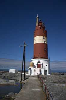
Haugjegla Lighthouse
 | |
 | |
| Location | Møre og Romsdal, Norway |
|---|---|
| Coordinates | 63°32′00″N 07°57′45″E / 63.53333°N 7.96250°ECoordinates: 63°32′00″N 07°57′45″E / 63.53333°N 7.96250°E |
| Year first constructed | 1922 |
| Year first lit | first light set up in 1905 |
| Automated | 1988 |
| Tower shape | Cylindrical |
| Markings / pattern | Red with white stripe |
| Height | 27.8 metres (91 ft) |
| Focal height | 26.5 metres (87 ft) |
| Intensity | 126,000 candela |
| Range | 15.3 nmi (28.3 km; 17.6 mi) |
| Characteristic | Oc(2) WRG 8s |
| Racon | B |
| Admiralty number | L1362 |
| NGA number | 7488 |
| ARLHS number | NOR-109 |
| Norway number | 435000 |
Haugjegla Lighthouse (Norwegian: Haugjegla fyr; also spelled: Hauggjegla) is a coastal lighthouse located in Smøla Municipality in Møre og Romsdal county, Norway. It is located on a waveswept skerry about 1 kilometre (0.62 mi) north of Veiholmen on the north side of the island of Smøla. The lighthouse is only accessible by boat. The lighthouse is listed as a protected site.[1]
The first light was set up in 1905, the present tower was built in 1922, and the station was automated in 1988.[2] The 28-metre (92 ft) tall round, cylindrical, cast iron tower is painted red with a white stripe around it. The concrete base is painted white. The light at the top emits a white, red, or green light (depending on direction) occulting twice every 8 seconds. The 126,000-candela light can be seen for up to 15.3 nautical miles (28.3 km; 17.6 mi).[3][4]
See also
References
- ↑ "Haugjegla fyrstasjon" (in Norwegian). Norsk Fyrhistorisk Forening. Retrieved 14 December 2011.
- ↑ Henriksen, Petter (ed.). "Haugjegla fyr". Store norske leksikon (in Norwegian). Oslo: Kunnskapsforlaget. Retrieved 14 December 2011.
- ↑ Rowlett, Russ (19 July 2011). "Lighthouses of Norway: Kristiansund Area". University of North Carolina at Chapel Hill. Retrieved 2013-04-07.
- ↑ Kystverket (2012). Norske Fyrliste 2012 (PDF) (in Norwegian). ISBN 9788245013542.