Hatun K'irawniyuq
| Hatun K'irawniyuq | |
|---|---|
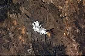 Coropuna (snow covered) and Hatun K'irawniyuq (upper center, to the left) as seen from the air | |
| Elevation | 4,731.1 m (15,522 ft)[1] |
| Location | |
 Hatun K'irawniyuq Peru | |
| Location | Peru, Arequipa Region, Condesuyos Province, La Unión Province |
| Range | Andes |
| Coordinates | 15°26′36″S 72°42′26″W / 15.44333°S 72.70722°WCoordinates: 15°26′36″S 72°42′26″W / 15.44333°S 72.70722°W |
Hatun K'irawniyuq (Quechua hatun big, k'iraw cradle, bed of a child, -ni, -yuq suffixes,[2][3] "the one with a big cradle" or "the big one with a cradle", hispanicized spelling Jatun Quirauniyoc) is a mountain in the Arequipa Region in the Andes of Peru, about 4,731.1 metres (15,522 ft) high. It is situated in the Condesuyos Province, Salamanca District, north of the volcano Coropuna. The peak west of K'irawniyuq is named Quri Qhawana (Ccorecahuana). One of the nearest populated places is Mawk'allaqta (Quechua for "old town", Maucallacta) in the northeast. The village is situated at the mountain Mawk'a Llaqta (Mauca Llacta).[4]
References
- ↑ "South America Maps". Joint Operations Graphic. Retrieved July 6, 2014.
- ↑ Diccionario Quechua - Español - Quechua, Academía Mayor de la Lengua Quechua, Gobierno Regional Cusco, Cusco 2005 (Quechua_Spanish dictionary)
- ↑ Teofilo Laime Ajacopa, Diccionario Bilingüe Iskay simipi yuyayk'ancha, La Paz, 2007 (Quechua-Spanish dictionary)
- ↑ escale.minedu.gob.pe - UGEL map of the Condesuyos Province (Arequipa Region)