Hat Creek
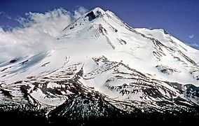
Hat Creek is a 48.7-mile-long (78.4 km)[1] stream in Shasta County in northern California. The creek rises in two forks on the eastern slopes of Lassen Peak in Lassen Volcanic National Park, and flows northward through Lassen National Forest to its mouth at Lake Britton near Burney, California.[2]
Hat Creek is so named because a surveyor lost his hat there.[3]
Wild Trout Waterway
The lower three and a half miles of the creek has been designated by the California Department of Fish and Game as a "Wild Trout Waterway," with restrictive catch limits. This area has a similar geology to the chalk streams of southern England, and is considered a classic trout stream. The trout population is made of wild rainbow and brown trout of up to 20 inches (510 mm) in length.
Towns
The main towns along Hat Creek are Hat Creek and Old Station, which is closer to Lassen Park. The Hat Creek Radio Observatory is located near the town of Hat Creek.
During the May 19, 1915 eruption of Mount Lassen, a lahar or mudflow swept down Hat Creek and neighboring Lost Creek.[4]
Coordinates: 40°59′23″N 121°34′43″W / 40.989606°N 121.578596°W
References
- ↑ U.S. Geological Survey. National Hydrography Dataset high-resolution flowline data. The National Map, accessed March 10, 2011
- ↑ U.S. Geological Survey Geographic Names Information System: Hat Creek
- ↑ "Sierra Nevada Geotourism MapGuide: Hat Creek Rim Overlook". National Geographic.
- ↑ "Lassen Peak Eruptive Activity 1914-1921". Cascades Volcanoes Observatory, USGS. 2004-12-01. Retrieved 2009-08-29.
- Wild trout & catch-and-release waters; "Hat Creek"; California Department of Fish and Game; 2003; url accessed October 26, 2006
- Hat Creek Fly Fishing; Troutsource.com; url accessed October 26, 2006
| ||||||||||||||||||||||||||||