Hasty, Colorado
| Hasty, Colorado | |
|---|---|
| Census-designated place | |
 Hasty Location in Colorado | |
| Coordinates: 38°06′45″N 102°57′26″W / 38.11250°N 102.95722°WCoordinates: 38°06′45″N 102°57′26″W / 38.11250°N 102.95722°W | |
| Country |
|
| State |
|
| Counties | Bent[1] |
| Area | |
| • Total | 0.3 sq mi (0.9 km2) |
| • Land | 0.3 sq mi (0.9 km2) |
| • Water | 0 sq mi (0 km2) |
| Elevation[1] | 3,870 ft (1,180 m) |
| Population (2010) | |
| • Total | 144 |
| • Density | 409/sq mi (157.9/km2) |
| Time zone | MST (UTC-7) |
| • Summer (DST) | MDT (UTC-6) |
| ZIP code[2] | 81044 |
| Area code(s) | 719 |
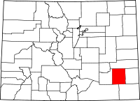
Hasty is a census-designated place and a U.S. Post Office located in Bent County, Colorado, United States. The population as of the 2010 Census was 144.[3] The Hasty Post Office has the ZIP Code 81044.[2]
Geography
Hasty is located in northeast Bent County at 38°06′45″N 102°57′26″W / 38.11250°N 102.95722°W (38.112410,-102.957344), just north of the dam for John Martin Reservoir on the Arkansas River. U.S. Highway 50 passes through the community, leading west 16 miles (26 km) to Las Animas, the county seat, and east 20 miles (32 km) to Lamar.
See also
- Outline of Colorado
- State of Colorado
- Colorado cities and towns
- Colorado census designated places
- Colorado counties
- Colorado cities and towns
References
- ↑ 1.0 1.1 "US Board on Geographic Names". United States Geological Survey. 2007-10-25. Retrieved 2008-01-31.
- ↑ 2.0 2.1 "ZIP Code Lookup" (JAVASCRIPT/HTML). United States Postal Service. December 15, 2006. Retrieved December 15, 2006.
- ↑ Colorado Trend Report 2: State and Complete Places (Sub-state 2010 Census Data). Missouri Census Data Center. Accessed 2011-02-25.
| |||||||||||||||||||||
