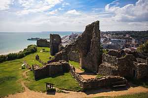
Hastings Castle
| Hastings Castle | |
|---|---|
| Hastings, East Sussex | |
 General view of Hastings Castle General view of Hastings Castle | |
 Hastings Castle | |
| Coordinates | grid reference TQ822095 |
| Type | Keep and bailey |
| Site information | |
| Owner | Local Authority |
| Open to the public | Yes |
| Condition | Fragmented Ruins |
| Site history | |
| Built | 12th Century |
| Materials | Stone |
| Demolished | Ruined by 1399 |
Hastings Castle is a keep and bailey castle ruin situated in the town of Hastings, East Sussex.
_-_WGA24172.jpg)
History
Immediately after landing in England in 1066 William of Normandy ordered three fortifications to be built, Pevensey Castle in September 1066, Hastings (before the Battle of Hastings) and Dover, a few days after the battle. Hastings Castle was originally built as a motte-and-bailey castle near the sea. In 1070 William had issued orders for the Castle to be rebuilt in stone, along with the St Mary's Chapel.
The Count of Eu held the castle for most of the Norman period, but King John ordered that the castle be destroyed to prevent it falling into the hands of the Dauphin Louis. In 1220, Henry III re-fortified the castle.
In 1287 violent storms battered the south coast for many months and the soft sandstone cliffs eventually succumbed to the elements. Large sections of the face fell into the sea along with parts of the castle.
In 1339 and 1377, the town was attacked by the French leaving many burnt buildings which included homes. Throughout the next century erosion was unchecked and gradually more of the castle was lost to the sea.
The mid 16th century saw the castle receive another blow as Henry VIII commissioned that all Catholic monasteries were to be destroyed and this left the site in decay for many years. After that the site was purchased by the Pelham family and used for farming until the ruins had become so overgrown they were lost from memory.
During World War II, the castle received more damage as Hastings was a target for bombing raids. In 1951 the Hastings Corporation purchased the site and converted it into a tourist attraction.
References
- Hastings Castle Official Site
- Hastings Castle 2
- Hastings Castle 3
- Hastings Castle as a tourist attraction
- Fry, Plantagenet Somerset, The David & Charles Book of Castles, David & Charles, 1980. ISBN 0-7153-7976-3
External links
 Media related to Hastings Castle at Wikimedia Commons
| ||||||||||||||||||||||||||||||||||