Haskeir
Not to be confused with Hyskeir or Heskeir
| Location | |
|---|---|
 Haskeir Haskeir shown within the Outer Hebrides | |
| OS grid reference | NF615818 |
| Names | |
| Gaelic name | Eilean Hasgeir |
| Norse name | Skilðar |
| Meaning of name | Possibly Old Norse for 'shields' |
| Physical geography | |
| Island group | Uists and Barra |
| Area | 15 ha |
| Highest elevation | 37.5 m |
| Political geography | |
| Sovereign state | United Kingdom |
| Country | Scotland |
| Council area | Na h-Eileanan Siar |
| Demographics | |
| Population | nil |
| References | [1][2] |
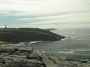
Haskeir (Scottish Gaelic: Eilean Hasgeir), also known as Great Haskeir (Scottish Gaelic: Hasgeir Mhòr) is a remote, exposed and uninhabited island in the Outer Hebrides of Scotland. It lies 13 kilometres (8.1 mi) west north west of North Uist. 1-kilometre (0.62 mi) to the south west lie the skerries of Haskeir Eagach made up of a colonnade of five rock stacks. 40 kilometres (25 mi) to the north west is the St Kilda archipelago.
Geography, geology and botany
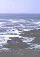
There is no anchorage or shelter and access via the steep rocky cliffs may be difficult, even in calm conditions. There are several natural rock arches and a high cliff on the northern end of the island called Castle Cliff. Various small skerries lie immediately to the north and south. There is very little vegetation save for a few sea-pinks, campion, plantain and orache that can survive the salt spray. [1]
Much of the bedrock is Lewisian gneiss [3]
History
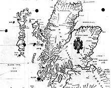
Skilðar or Skilðir (meaning shields) may have been the Old Norse name for Haskeir.[4][5] Skildar certainly appears on a map by Nicholas de Nicolay from 1583. There are various theories that somehow the transposition of this name to nearby St Kilda may have created the name for this latter archipelago, whose origins are otherwise obscure.[6][7]
There is a lighthouse on the island constructed in 1997 and the remains of a bothy, possibly built by fishermen from the Monach Islands.
References
- ↑ 1.0 1.1 Haswell-Smith, Hamish. (2004) The Scottish Islands. Edinburgh. Canongate.
- ↑ Ordnance Survey "Get-a-Map"
- ↑ "The Lewisian Gneiss of North Castle, Haskeir:: OS grid NF6182 :: Geograph Britain and Ireland - photograph every grid square!". Geograph.org.uk. Retrieved 2012-04-29.
- ↑ Maclean, Charles (1977) Island on the Edge of the World: the Story of St. Kilda Canongate. ISBN 0-903937-41-7. Page 33.
- ↑ Fleming, Andrew (2005) St. Kilda and the Wider World: Tales of an Iconic Island. Windgather Press. ISBN 1-905119-00-3. Page 27. Maclean does not state which island caused the confusion, but Fleming equates 'Skilðir' with Haskeir.
- ↑ Quine, David (2000) St Kilda. Grantown-on-Spey. Colin Baxter Island Guides. ISBN 1-84107-008-4. Page 21. Quine, for example, suggests that Skildar was transcribed in error by Lucas J. Waghenaer in his 1592 charts without the trailing r and with a period after the S, creating S.Kilda. This was in turn assumed to stand for a saint by others, creating the form that has been used for several centuries, St Kilda.
- ↑ de Nicolay, Nicholas (1583) Vraye & exacte description Hydrographique des costes maritimes d'Escosse & des Isles Orchades Hebrides avec partie d'Angleterre & d'Irlande servant a la navigation. Edinburgh. National Library of Scotland. Retrieved 22 December 2007.
Gallery
-
Haskeir (on the right) and Haskeir Eagach from Griminish Point, North Uist
| ||||||||||||
