Hart bei Graz
| Hart bei Graz | ||
|---|---|---|
| ||
 Hart bei Graz Location within Austria | ||
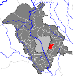
Location within Graz-Umgebung district
| ||
| Coordinates: 47°02′42″N 15°31′12″E / 47.04500°N 15.52000°ECoordinates: 47°02′42″N 15°31′12″E / 47.04500°N 15.52000°E | ||
| Country | Austria | |
| State | Styria | |
| District | Graz-Umgebung | |
| Government | ||
| • Mayor | Gerhard Payer (SPÖ) | |
| Area | ||
| • Total | 10.99 km2 (4.24 sq mi) | |
| Elevation | 450 m (1,480 ft) | |
| Population (1 January 2014)[1] | ||
| • Total | 4,547 | |
| • Density | 410/km2 (1,100/sq mi) | |
| Time zone | CET (UTC+1) | |
| • Summer (DST) | CEST (UTC+2) | |
| Postal code | 8075 | |
| Area code | 0316 | |
| Vehicle registration | GU | |
| Website | www.hartbeigraz.at | |

Hart bei Graz is a municipality in the district of Graz-Umgebung in the Austrian state Styria.
Geography
Hart lies in the east Styrian hills between Graz and Laßnitzhöhe.
The municipality consists of the Katastralgemeinden of Messendorf and Hart bei Sankt Peter as well as the communities of Hart, Messendorf, and Pachern.
Near Hart lies the palace of Lustbühel and the Technische Universität Graz (TU Graz).
Neighboring municipalities
| Graz | Kainbach bei Graz | |
| Graz | 
| Laßnitzhöhe |
| Graz | Raaba |