Harshaville, Ohio
| Harshaville, Ohio | |
|---|---|
| Unincorporated community | |
 Harshaville, Ohio | |
| Coordinates: 38°54′29″N 83°32′40″W / 38.90806°N 83.54444°WCoordinates: 38°54′29″N 83°32′40″W / 38.90806°N 83.54444°W | |
| Country | United States |
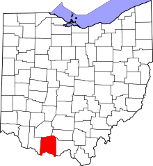
| State | Ohio |
| County | Adams |
| Elevation | 725 ft (221 m) |
| Time zone | Eastern (EST) (UTC-5) |
| • Summer (DST) | EDT (UTC-4) |
| Area code(s) | 937 |
| GNIS feature ID | 1064803[1] |
Harshaville, Ohio (also known as Harshasville[1]) is an unincorporated community in Adams County, Ohio, in the southern part of the state.
Harshaville had its start by the building of the Harsha Mill, a gristmill powered by the Cherry Fork Creek.[2] The community takes its name from the Harsha family.[3]
It is the location of Harshaville Covered Bridge, a historic bridge that is listed on the National Register of Historic Places.
Gallery
-
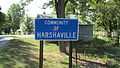
Harshaville community sign.
-
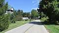
Looking east on Graces Run Road in Harshaville.
-
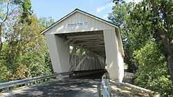
Harshaville Covered Bridge
References
- ↑ 1.0 1.1 "Locust Grove". Geographic Names Information System. United States Geological Survey.
- ↑ Evans, Nelson Wiley (1900). A History of Adams County, Ohio: From Its Earliest Settlement to the Present Time. E B. Stivers. p. 453.
- ↑ Lorrie K. Owen, ed. (1999). Ohio Historic Places Dictionary, Volume 2. Somerset Publishers, Inc. p. 3.
| |||||||||||||||||||||||||