Harrison Township, Cass County, Indiana
| Harrison Township | |
|---|---|
| Township | |
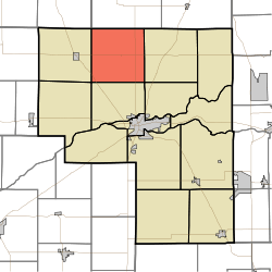 Location of Harrison Township in Cass County | |
| Coordinates: 40°51′58″N 86°24′18″W / 40.86611°N 86.40500°WCoordinates: 40°51′58″N 86°24′18″W / 40.86611°N 86.40500°W | |
| Country | United States |
| State | Indiana |
| County | Cass |
| Government | |
| • Type | Indiana township |
| Area | |
| • Total | 35.49 sq mi (91.93 km2) |
| • Land | 35.49 sq mi (91.93 km2) |
| • Water | 0 sq mi (0 km2) |
| Elevation[1] | 797 ft (243 m) |
| Population (2010) | |
| • Total | 802 |
| • Density | 23/sq mi (8.7/km2) |
| FIPS code | 18-31666[2] |
| GNIS feature ID | 453380 |
Harrison Township is one of fourteen townships in Cass County, Indiana. As of the 2010 census, its population was 802.[3]
History
Harrison Township was organized in 1836.[4] It was named for William Henry Harrison, who had served as Governor of the Indiana Territory, congressman, senator, and who would afterward serve as the ninth President of the United States.[5]
Geography
Harrison Township covers an area of 35.49 square miles (91.9 km2), all land.
Unincorporated towns
Adjacent townships
- Wayne Township, Fulton County (north)
- Bethlehem (east)
- Clay (southeast)
- Noble (south)
- Jefferson (southwest)
- Boone (west)
- Van Buren Township, Pulaski County (northwest)
Major highways
Cemeteries
The township contains four cemeteries: Crooked Creek, Grant, Old Indian Creek and Saint Elizabeth.
References
- "Harrison Township, Cass County, Indiana". Geographic Names Information System. United States Geological Survey. Retrieved 2009-09-24.
- United States Census Bureau cartographic boundary files
- ↑ "US Board on Geographic Names". United States Geological Survey. 2007-10-25. Retrieved 2008-01-31.
- ↑ "American FactFinder". United States Census Bureau. Retrieved 2008-01-31.
- ↑ "Geographic Identifiers: 2010 Demographic Profile Data (G001): Harrison township, Cass County, Indiana". U.S. Census Bureau, American Factfinder. Retrieved January 15, 2013.
- ↑ Powell, Jehu Z. (1913). History of Cass County Indiana: From Its Earliest Settlement to the Present Time. Lewis Publishing Company. p. 573.
- ↑ Helm, Thomas B. (1878). History of Cass County, Indiana. Kingman Bros. p. 34.
External links
| |||||||||||||||||||||||||||||||||