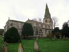
Harringworth
| Harringworth | |
 Church of St John the Baptist, Harringworth |
|
 Harringworth |
|
| Population | 247 |
|---|---|
| OS grid reference | SP9197 |
| District | East Northamptonshire |
| Shire county | Northamptonshire |
| Region | East Midlands |
| Country | England |
| Sovereign state | United Kingdom |
| Post town | Corby |
| Postcode district | NN17 |
| Dialling code | 01572 |
| Police | Northamptonshire |
| Fire | Northamptonshire |
| Ambulance | East Midlands |
| EU Parliament | East Midlands |
| UK Parliament | Corby |
|
|
Coordinates: 52°34′03″N 0°39′05″W / 52.5676°N 0.6515°W

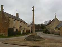
Harringworth Cross
Harringworth is a village and civil parish in East Northamptonshire extremely close to the Northants-Rutland border. At the time of the 2001 census, the parish's population was 247 people.[1]
It lies on the southern bank of the River Welland; the area is dominated by a railway viaduct, the Welland Viaduct (known locally as "the Harringworth Viaduct") that crosses the Welland and its flood plain immediately to the west of the village. For many centuries in medieval England Harringworth was associated with the Zouche family who were Lords of the Manor.
See also
References
- ↑ Office for National Statistics: Harringworth CP: Parish headcounts. Retrieved 12 November 2009
External links
![]() Media related to Harringworth at Wikimedia Commons
Media related to Harringworth at Wikimedia Commons