Harmar Historic District
|
Harmar Historic District | |
 | |
|
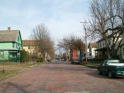
Maple Street looking east. | |
 | |
| Location | Marietta, Ohio |
|---|---|
| Coordinates | 39°24.5′N 81°27.5′W / 39.4083°N 81.4583°WCoordinates: 39°24.5′N 81°27.5′W / 39.4083°N 81.4583°W |
| Area | 1,475 acres (597 ha) |
| NRHP Reference # |
74001645 93000987[1] |
The Harmar Historic District is a historic district related to the early settlement of the Northwest Territory. It is located in the present day Marietta, Washington County, Ohio, USA.
The district contains the Putnam House and the site of Fort Harmar, among 199 buildings and 3 structures.
References
- ↑ "National Register Information System". National Register of Historic Places. National Park Service. 2010-07-09.
| |||||||||||||||||||||||||
| ||||||||||||||||||||||||||
