Hardy Toll Road
| |
|---|---|
|
Hardy Toll Road highlighted in red | |
| Route information | |
| Maintained by HCTRA | |
| Length: | 21.6 mi (34.8 km) |
| Existed: | 1988 – present |
| Major junctions | |
| South end: |
|
|
| |
| North end: |
|
| Location | |
| Counties: | Harris |
| Highway system | |

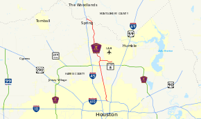
The Hardy Toll Road runs from Interstate 610, near central Houston, to Interstate 45, north of Houston just below the Harris County line. The road generally parallels Interstate 45. The portion from I-610 to Crosstimbers Road is known as Spur 548, although this is unsigned.[1] [2]
Construction on the toll road started in September 1984 and the entire road was complete by June 1988.[3] The toll road runs 21.6 miles (34.8 km) [3] and costs $3.50 to drive its full length ($1.75 north of Beltway 8 and $1.75 south of Beltway 8). A four-mile (6 km) connecting road to the George Bush Intercontinental Airport requires a $1.25 toll. At Hardy North and South toll booths, a 20 cent discount applies to electronic EZ TAG users.
The road is named for nearby Hardy Street, which makes up the frontage roads for the toll road in two locations: (1) between Spring Railroad Yard and FM 1960 and (2) Greens Road to Crosstimbers Road.
A large portion of the southern segment resembles Austin's Mopac Expressway in that an active line of the Union Pacific railroad runs along its median. Like other toll roads in the Houston area, the speed limit is 65 mph (105 km/h), even inside Beltway 8.
Planned extensions
Southward
Future plans are to extend the toll road south an additional four miles (6 km) into downtown Houston (the northern most mile marker is 25, though the current road is only 21.6 miles (34.8 km) long). In November '07 the city of Houston gave approval for street closures required to construct the connections to the downtown freeway loop. Originally, construction was scheduled to start in August 2009 with completion sometime in 2011; however, this has been delayed. It is expected that the toll road will deviate from Hardy Street south of I-610 and follow Maury Street [4] to connect with the Eastex Freeway near I-10,[5] as part of the ramp connections have already been built.[6]
As of November 23, 2010, construction on the Hardy Toll Road Downtown connector has still not begun, with HCTRA's website reporting the project is still under design.[7]
Northward
As the population of Montgomery County has grown quickly in recent years, the need for a northward extension is being evaluated. Originally, the plan was to construct the extension along the right of way for the railroad. However, recent growth in Oak Ridge North will require that the Hardy Toll Road extension deviate from this right of way in places. Feasibility studies have evaluated possible routes between FM 1314 and the San Jacinto River, with the northern terminus planned to be at Loop 336. No plans for construction have yet been formulated.[8]
Lane count
The following are the number of mainlanes in each direction, as of August 2008:
- 3 lanes each way between Interstate 610 and Beltway 8 (northbound exit/southbound entry)
- 2 lanes each way crossing over the Beltway 8 frontage roads
- 3 lanes each way between Beltway 8 (northbound entry/southbound exit) and FM 1960
- 2 lanes each way between FM 1960 and Hardy North Toll Plaza
- 3 lanes each way between Hardy North Toll Plaza and East Louetta Road
- 2 lanes each way between East Louetta Road and Interstate 45 (northern terminus)
Exit list
The entire route is in Harris County. All exits are unnumbered.
| Location | mi | km | Destinations | Notes | |
|---|---|---|---|---|---|
| Houston | Southbound exit and northbound entrance | ||||
| Hardy Road | Southbound exit and northbound entrance | ||||
| Crosstimbers Road | |||||
| Tidwell Road, Parker Road, Berry Road | |||||
| Little York Road, Gulf Bank Road | |||||
| Aldine | |||||
| Toll plaza | |||||
| Houston | Central Green Boulevard, Greens Road, Hardy Airport Connector – Intercontinental Airport | ||||
| Rankin Road | |||||
| Houston | Richey Road, East Hardy Street | ||||
| Westfield | |||||
| Toll plaza | |||||
| Spring | Aldine–Westfield Road, East Louetta Road | Northbound exit and southbound entrance | |||
| Riley Fuzzel Road | Northbound exit and southbound entrance | ||||
| Northgate Crossing Boulevard, Spring Crossing Boulevard | Northbound exit and southbound entrance | ||||
| Northbound exit and southbound entrance | |||||
| 1.000 mi = 1.609 km; 1.000 km = 0.621 mi | |||||
Airport Connector
The entire route is in Houston, Harris County.
| mi[9] | km | Destinations | Notes | ||
|---|---|---|---|---|---|
| 0.0 | 0.0 | Hardy Toll Road – Houston, Dallas | Westbound exit and eastbound entrance | ||
| 0.5 | 0.8 | Central Green Boulevard, Greens Road | Westbound exit and eastbound entrance | ||
| 0.9 | 1.4 | Waverly Drive, Aldine Westfield Road | Eastbound exit and westbound entrance | ||
| 3.4 | 5.5 | John F. Kennedy Boulevard north – Intercontinental Airport | Eastbound exit and westbound entrance | ||
| 1.000 mi = 1.609 km; 1.000 km = 0.621 mi | |||||
See also
- Houston portal
- U.S. Roads portal
References
- ↑ Texas Transportation Commission (February 22, 2001). "Texas Transportation Commission Agenda". Texas Department of Transportation. Retrieved September 29, 2006.
- ↑ Stanek, David (December 29, 2000). "State Highway Spurs". Texas Highway Routes. Archived from the original on August 8, 2009. Retrieved September 29, 2006.
- ↑ 3.0 3.1 Staff. "HCTRA Project History". Harris County Toll Road Authority. Retrieved September 29, 2006.
- ↑ Slotboom, Erik (March 2006). "Houston Photos". Houston Freeways. Retrieved September 29, 2006.
- ↑ Sallee, Rad (June 12, 2006). "Hardy Toll Road goal still two years away". Houston Chronicle. Retrieved September 29, 2006.
- ↑ Google (October 23, 2006). "Satellite image: Exit ramp from Northbound U.S. 59 to Westbound Interstate 10 showing stub for future ramp to Northbound Hardy Toll Road" (Map). Google Maps. Google. Retrieved October 23, 2006. (Note: US 59 in this image is shown under construction, prior to 2003.)
- ↑ "Construction & Engineering: Major Projects". Harris County Toll Road Authority.
- ↑ Kuhles, Beth (May 29, 2003). "Hardy Toll Road extension is eyed into Montgomery County". Houston Chronicle. Retrieved September 29, 2006.
- ↑ "Overview Map of Hardy Toll Road Airport Connector". Google Maps. Google. Retrieved July 13, 2014.
External links
Route map: Bing
| ||||||||||||||||||