Hansborough, South Australia
| Hansborough South Australia | |
|---|---|
|
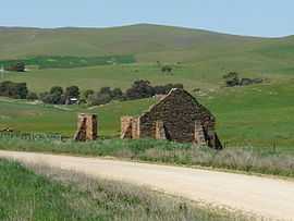
Ruins located at Hansborough | |
 Hansborough | |
| Coordinates | 34°15′04″S 139°01′30″E / 34.251°S 139.025°ECoordinates: 34°15′04″S 139°01′30″E / 34.251°S 139.025°E |
| Established | 1865 |
| Postcode(s) | 5374 |
| Location |
|
| LGA(s) | Regional Council of Goyder |
| State electorate(s) | Stuart |
| Federal Division(s) | Wakefield |
Hansborough is a locality along the former Morgan railway line adjacent to the Thiele Highway, in South Australia's Mid North region. It is situated 9 kilometres south-west of Eudunda and 18 kilometres north-east of Kapunda. The Light River runs through the locality.
The town was originally surveyed in July 1865 and is named after early pastoralist and overlander Frederick Hansborough Dutton (1812-1890), who founded Anlaby Station, near Kapunda.[1] Today it is virtually a ghost town, with a number of ruins at the site.
See also
References
| ||||||
| ||||||