Hangzhou Bay
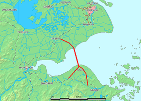
Hangzhou Bay, or the Bay of Hangzhou (simplified Chinese: 杭州湾; traditional Chinese: 杭州灣; pinyin: Hángzhōu Wān), is an inlet of the East China Sea, bordered by the province of Zhejiang and the municipality of Shanghai. The Qiantang River flows into the bay.
It lies south of Shanghai, and ends at the city of Hangzhou. Hangzhou Bay contains many small islands collectively called the Zhoushan Islands.
The bay is known for hosting the world's largest tidal bore, being up to 9 metres (30 ft) high, and travelling up to 40 km (25 mi) per hour. The tidal bore is especially high during the Mid-Autumn Festival when several thousand tourists come to watch the magnificent Qiantang Tidal Bore.
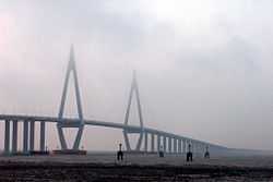
The bay is spanned by the Hangzhou Bay Bridge, which was linked up on June 14, 2007 and opened on 1 May, 2008. The then second-longest bridge in the world, it cuts the trip between eastern Zhejiang and Shanghai from 400 to 80 kilometres (250 to 50 miles).
The entire bay area is shallow with less than 15 meters sea depth. The bay area (nearly 10,000 sq. km) including adjoining Yangtze river estuary can be converted in to fresh water reservoir by feeding flood water from the Yangtze river. The fresh water reservoir storage capacity would be bigger than the Three Gorges Reservoir. This is possible by constructing sea dikes / bunds/ Causeway up to 15 meters water depth for isolating the area from the sea. These proposed dikes would be similar to the land reclamation of North Sea area called Delta Works in Netherlands.The deep sea facing dikes extending 10 meters above the local mean sea level would protect the bay from the tidal bores. The deep sea facing dikes can also be used as sea ports for large ships and top surface as coastal road & rail rout for connecting most of the bay islands. The isolated bay area can also be interconnected to sea via locks for using the bay area for shipping, ship breaking, ship building, etc. purposes. The stored fresh water in the bay area is used for municipal water needs and agriculture water needs by pumping from the sea level fresh water reservoir.
See also
External links
| ||||||
| ||||||||||||||||||||||||||||||||||
Coordinates: 30°17′07″N 120°55′26″E / 30.2852°N 120.924°E