Hanak
| Hanak | |
|---|---|
 | |
 Hanak | |
| Coordinates: 41°14′10″N 42°50′50″E / 41.23611°N 42.84722°ECoordinates: 41°14′10″N 42°50′50″E / 41.23611°N 42.84722°E | |
| Country | Turkey |
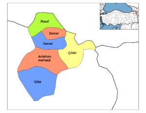
| Province | Ardahan |
| Government | |
| • Mayor | Ayhan Büyükkaya (CHP) |
| • Kaymakam | Süleyman Ovalı |
| Area[1] | |
| • District | 546.78 km2 (211.11 sq mi) |
| Population (2012)[2] | |
| • Urban | 3,943 |
| • District | 9,891 |
| • District density | 18/km2 (47/sq mi) |
| Post code | 75900 |
| Website |
www |
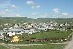
Hanak is a district of Ardahan Province of Turkey, on the road from Ardahan to Posof, in kurdish Xanek
Hanak sits in the valley of the Hanak River with high mountains on all sides, Ilgar to the north being the highest at 2915m. The weather, like all districts of Ardahan, is very, very cold and dry especially on the mountainsides where the cold weather begins in September, the snow will not melt until May, avalanches are common and the road to Posof is frequently closed. In summers it rains.
Until the 18th century, these mountains were covered in forest, but now they are bare hillsides apart from one or two patches of pine forest. The local economy depends on grazing cattle.
History
See Erusheti and Ardahan Province for the history of this area, including Hanak, long settled by the Kipchak branch of the Oghuz Turks, apart from brief periods of occupation by Russia in the late 19th and early 20th century.
Villages
- Altınemek
- Arıkonak
- Aşağıaydere
- Baştoklu
- Binbaşak
- Börk
- Çatköy
- Çavdarlı
- Çayağzı
- Çiçeklidağ
- Çimliçayır
- Dilekdere
- Geçköy
- Güneşgören
- İncedere
- Karakale
- Koyunpınarı
- Oğuzyolu
- Ortakent
- Sazlıçayır
- Serinkuyu
- Sevimli
- Sulakçayır
- Yamaçyolu
- Yamçılı
- Yukarıaydere
- Yünbüken
References
- ↑ "Area of regions (including lakes), km²". Regional Statistics Database. Turkish Statistical Institute. 2002. Retrieved 2013-03-05.
- ↑ "Population of province/district centers and towns/villages by districts - 2012". Address Based Population Registration System (ABPRS) Database. Turkish Statistical Institute. Retrieved 2013-02-27.
See also
- Hanák
- Hanakia