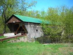
Hammond Covered Bridge
|
Hammond Covered Bridge | |
 | |
 | |
| Nearest city | Pittsford, Vermont |
|---|---|
| Coordinates | 43°43′14″N 73°3′14″W / 43.72056°N 73.05389°WCoordinates: 43°43′14″N 73°3′14″W / 43.72056°N 73.05389°W |
| Area | 1 acre (0.40 ha) |
| Built | 1842 |
| Architectural style | Other, Town lattice truss |
| Governing body | Local |
| NRHP Reference # | 74000256[1] |
| Added to NRHP | January 21, 1974 |
Hammond Covered Bridge is a town lattice covered bridge spanning Otter Creek in Pittsford, Vermont. The bridge was built in 1842 by Asa Norse. In 1927, a flood swept the bridge 1.5 miles (2.4 km) downstream but left the structure intact. Since it was still functional, the bridge was placed on barrels and transported back to its original location; it is now called "the bridge that went on a voyage". The bridge was later bypassed by a steel and concrete bridge on Kendall Hill Road and is closed to vehicle traffic.[2]
The bridge was added to the National Register of Historic Places on January 21, 1974.[1] In 2000, a state official estimated that it would cost $250,000 to preserve the bridge.[2]
References
- ↑ 1.0 1.1 "National Register Information System". National Register of Historic Places. National Park Service. 2010-07-09.
- ↑ 2.0 2.1 Evans, Benjamin D.; June R. Evans (2012). New England's Covered Bridges: A Complete Guide. University Press of New England. ISBN 9781611683851.
| ||||||||||||||||||||||||||