Hamilton Hill, Western Australia
| Hamilton Hill Perth, Western Australia | |||||||||||||
|---|---|---|---|---|---|---|---|---|---|---|---|---|---|
|
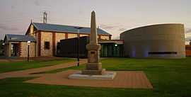
Memorial Hall, built 1925, renovated and extended 2008 | |||||||||||||
 Hamilton Hill | |||||||||||||
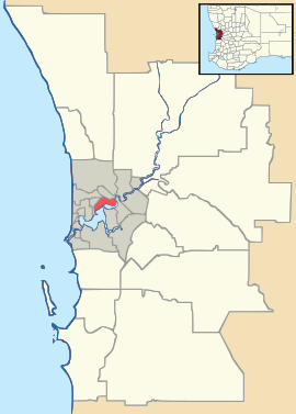
| Coordinates | 32°04′48″S 115°46′30″E / 32.08°S 115.775°ECoordinates: 32°04′48″S 115°46′30″E / 32.08°S 115.775°E | ||||||||||||
| Population | 9,257 (2006 census)[1] | ||||||||||||
| • Density | 1,172/km2 (3,035/sq mi) | ||||||||||||
| Postcode(s) | 6163 | ||||||||||||
| Area | 7.9 km2 (3.1 sq mi) | ||||||||||||
| Location |
| ||||||||||||
| LGA(s) | City of Cockburn | ||||||||||||
| State electorate(s) | Fremantle, Willagee | ||||||||||||
| Federal Division(s) | Fremantle | ||||||||||||
| |||||||||||||
Hamilton Hill is a suburb of Perth, the capital city of Western Australia 23 kilometres (14 mi) southwest of Perth's central business district. Its local government area is the City of Cockburn.
History
The earliest known settler at Hamilton Hill was Sydney Smith, the agent of Captain George Robb. Robb arrived in Western Australia in 1830 and took up land south of Fremantle. During the next twelve months Smith was actively engaged in establishing Robb's farm. In a letter dated 27 August 1830, he gives his address as Hamilton Hill. The origin of the name, and whether it was Robb or Smith who did the naming, remains uncertain but the area has been known as such ever since.[2]
In 1860 Charles Alexander Manning bought 364ha of Robb's land, and six years later built Davilak House for his son Lucius Manning.[3] The house of twelve rooms, was built using convict labour[4] and was owned by the Manning family until they abandoned it in the late 1950s. It burnt down in 1960, and after this the Shire of Cockburn took over the administration of the whole estate.
A second homestead was built in 1920 by the eldest daughter of Lucius Manning, Azelia Ley. She had married John Morgan Ley in 1900, and after he died in 1927 she continued to maintain the family farm.[3] This house became derelict after Azelia died in 1954, but was restored by the Historical Society of Cockburn in 1983 and now serves as a comprehensive Azelia Ley Homestead Museum of artifacts pertaining to the Cockburn district.
Geography
Hamilton Hill is bounded by Cockburn Road to the west, Phoenix Road to the south, Stock Road to the east and Jean Street and Winterfold Road to the north.[5]
Facilities
Educational
Hamilton Hill has one high school, Hamilton Senior High School, and two primary schools, East Hamilton Hill Primary School and Southwell Primary School
Recreational
Manning Reserve is a 900-acre (3.6 km2) reserve in southwestern Hamilton Hill. Its name comes from the family who were well known in the area from 1859 onwards.
Cultural
A historical building, the Azelia Ley Homestead Museum, is located within the boundaries of Manning Reserve. This building was restored by the Cockburn Council and prominent residents in 1983.[6]
References
- ↑ Australian Bureau of Statistics (25 October 2007). "Hamilton Hill (State Suburb)". 2006 Census QuickStats. Retrieved 2008-10-05.
- ↑ Western Australian Land Information Authority. "History of metropolitan suburb names". Retrieved 2007-05-30.
- ↑ 3.0 3.1 The Historical Society of Cockburn, Azelia Ley Homestead Museum pamphlet
- ↑ Information board at Davilak House ruins
- ↑ Department of Land Information. StreetSmart® Perth Street Directory (54 (2013) ed.). West Australian Newspapers Ltd. pp. Maps 430–431, 460–461. ISBN 978-0-909439-67-5.
- ↑ Nevill, Simon (2001). Travellers guide to the Parks and Reserves of Western Australia. Simon Nevill Publications. ISBN 0-9585367-1-6.