Hallowell Historic District
|
Hallowell Historic District | |
 | |
| Location | Hallowell, Maine |
|---|---|
| Coordinates | 44°17′10″N 69°47′30″W / 44.28611°N 69.79167°WCoordinates: 44°17′10″N 69°47′30″W / 44.28611°N 69.79167°W |
| Area |
260 acres 446 buildings |
| Built | 1825-1899 |
| Architect | Alexander C. Currier; John Calvin Stevens; et al. |
| Architectural style | Federal, Mid 19th Century Revivals, Late Victorian |
| Governing body | Private, State, Local |
| NRHP Reference # | 70000076 |
| Added to NRHP | October 28, 1970[1] |
Hallowell Historic District, also called "The Hillside of Hallowell," is a National Register of Historic Places district in Hallowell, Kennebec County, Maine. It encompasses 260 acres, and includes 446 buildings as contributing properties. Among these are:
- Artemus Leonard House (c. 1811).
- Capt. Samuel Watts House (1820).
- Old Fire Station (c. 1830).
- Hallowell Cotton Mill (1844).
- Gage Row House (1846), housing for textile workers.
- Capt. Henry Cooper House (1850).
- St. Matthew's Episcopal Church (1860), Richard Upjohn, architect.[2]
- Hallowell Granite Company Headquarters (c. 1870).
- Gov. Joseph R. Bodwell House (1875).
- Hubbard Free Library (1879–80), Alexander C. Currier, architect.
- Old South Congregational Church (1885).
- Hallowell City Hall (1898).
- Johnson House (1899), John Calvin Stevens, architect.
-

Capt. Samuel Watts House (1820).
-

Hallowell Cotton Mill (1844).
-
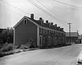
Gage Row House (1846).
-

St. Matthew's Episcopal Church (1860).
-
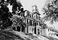
Gov. Joseph R. Bodwell House (1875).
-

Hubbard Free Library (1879–80), Alexander C. Currier, architect.
See also
External links
References
- ↑ "National Register Information System". National Register of Historic Places. National Park Service. 2008-04-15.
- ↑ Chiat, Marilyn Joyce Segal (1997). America's Religious Architecture: Sacred Places for Every Community. John Wiley & Sons. p. 24.