Hahntennjoch
| Hahntennjoch | |
|---|---|
|
View from the Hahntennjoch to the east | |
| Elevation | 1,894 m (6,214 ft) |
| Traversed by | Federal Highway B 189 |
| Location | Austria |
| Range | Alps |
| Coordinates | 47°17′N 10°39′E / 47.283°N 10.650°ECoordinates: 47°17′N 10°39′E / 47.283°N 10.650°E |
 Hahntennjoch Location of Hahntennjoch | |
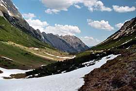
Hahntennjoch (el. 1894 m.) is a high mountain pass in the Austrian Alps in the Bundesland of Tyrol.
It connects the upper valley of the Inn River with the Lech River valley. The road leads from Imst to Elmen, a distance of 29 km. It is popular with motorcyclists and cyclists.
It is a much shorter route than the Fern Pass or the Flexen Pass over the Arlberg. The road is winding and steep, with grades up to 18.9 percent and is closed to traffic over 14 metric tons. The road is generally closed from November to April.
The pass is prone to avalanches, falling rocks, and mudslides. In 2004, an automatic system was installed that closes the road in case of blockage.
History
The present road was built in the late 1960s and opened in 1969.
See also
External links
References
| ||||||||