Hagiyama Station
Hagiyama Station 萩山駅 | |
| | |
|---|---|
| South entrance to Haigyama Station | |
| Location | |
| Prefecture | Tokyo (See other stations in Tokyo) |
| City | Higashimurayama |
| History | |
| Year opened | 1928 |
| Rail services | |
| Station number(s) | SS30, ST04 |
| Operator(s) | Seibu Railway |
| Line(s) | Seibu Haijima Line, Seibu Tamako Line |
| Statistics | 10,211 passengers/day (FY2013) |
Hagiyama Station (萩山駅 Hagiyama-eki) is a railway station in Higashimurayama, Tokyo, Japan, operated by the private railway operator Seibu Railway. It functions as an interchange between the Seibu Haijima Line and the Seibu Tamako Line which both offer through services to the Seibu Shinjuku Line.
Lines
Hagiyama Station is served by the Seibu Tamako Line and Seibu Haijima Line, with some through services to and from the Seibu Shinjuku Line.[1]
Services
Eastbound Seibu Haijima Line trains for Kodaira and central Tokyo (Takadanobaba Station and Seibu-Shinjuku Station) depart from Track 3. Westbound Seibu Haijima Line trains for Tamagawa Jōsui and Haijima Stations depart from Track 2.
Most trains to Seibu Yūenchi Station leave from Track 2. These trains are direct trains from Seibu Shinjuku Line.
Track 1 is used by Seibu Tamako Line trains running in both directions, mainly as a terminus for services to and from Kokubunji, but also through the Seibu Tamako Line to Seibu-Yūenchi Stations. Trains to/from Kokubunji, central Tokyo, and Seibu Yūenchi are timed to connect with each other and generally depart approximately every 10 minutes. Trains to Kokubunji occasionally depart from Platform 3, when Platform 1 is occupied by through trains to Seibu Yūenchi. This is due to the track layout.
All local and express trains stop at Hagiyama.
During the morning rush hours, some trains from Seibu Yūenchi and Haijima are coupled at Platform 3 to form ten-car express trains to central Tokyo.
Station Layout

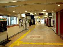
The station concourse consists as a bridge connecting the two platforms. Access to the concourse is available from both the North and South side of the tracks, by lifts and stairs. At the south exit, the bridge also extends over the main road, facilitating crossing, although lift access is not available on the far side of the road. During opening hours, the concourse can be used by pedestrians wishing to traverse the railway tracks. Opposite the ticket office, three gates control access to the platforms. Lifts and stairs descend to the east end of the platforms that are at street level. A cross-over foot bridge is also provided at the west end of the platforms to allow easy transfer between lines.
Platforms

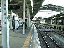
The station consists of two platforms. One is an island platform serving trains on Tracks 1 and 2; the other serves trains on Track 3.
Adjacent Stations
| « | Service | » | ||
|---|---|---|---|---|
| Kodaira | Seibu Haijima Line | Ogawa | ||
| Ōmekaidō | Seibu Tamako Line | Yasaka |
Hours of operation
Hagiyama Station's ticket office is open between 7:00 and 20:00.[2]
Facilities
The station has sets of toilets at concourse level both outside and inside the ticket gates. The station has a manned ticket office, as well as automatic ticket machines. Multilingual and Braille signage is available throughout the station. Within the ticket gates, a small kiosk operates at peak times. Several vending machines selling hot and cold beverages are distributed about the station
Taxis board passengers at the south exit. Bicycle parking is available for a fee outside the north side of the station, as is a small car parking lot.
History
Hagiyama Station opened on 6 April 1928[3] as a station on a new line connecting Moto-Kodaira with a new platform at Kokubunji. The Hagiyama to Kokubunji section of this line now forms the Seibu Tamako Line. It was relocated to its present location on 16 September 1958 to allow direct trains to Seibu Yūenchi from Kodaira and central Tokyo. This realignment means that it is no longer possible to run trains from Kodaira to Kokubunji. A spur was later added to allow services to travel to Haijima, via Ogawa, creating the Seibu Haijima line.
In 1992, the automatic ticket-collecting machines were installed.
Station numbering was introduced on all Seibu Railway lines during fiscal 2012, with Hagiyama Station becoming "SS30" on the Haijima Line and "ST04" on the Tamako Line.[4]
2008 refurbishment
A major refurbishment was completed in November 2008.[5] As part of this work, four lifts were installed allowing step-free access to all platforms and from street level at both entrances. Additional barrier-free improvements include new universal access toilets and a Braille map of the station. This work followed campaign from local residents demanding this provision.[6] The concourse was upgraded with additional toilets and new stairways and extensive external landscaping was carried out to the west entrance and east entrance, providing retail space for a stand-up noodle vendor adjacent to the station. Signage was upgraded on the platforms to the new Seibu Railways standard and multilingual concourse signs (Japanese, English, Chinese, and Korean) were also installed.
-

South pre-2008
-

South 2009
-
North pre-2008
-

North 2009
Passenger Statistics
In fiscal 2013, the station was the 67th busiest on the Seibu network with an average of 10,211 passengers daily.[7]
The passenger figures for previous years are as shown below.
| Fiscal year | Daily average |
|---|---|
| 2009 | 10,207[8] |
| 2010 | 10,200[8] |
| 2011 | 10,332[9] |
| 2012 | 10,323[10] |
| 2013 | 10,211[7] |
Surrounding area
Although Hagiyama Station is located on the edge the city of Higashimurayama in western Tokyo, its south entrance exits to the city of Kodaira.
The station provides the main access for the National Hospital Center of Neurology and Psychiatry (NCNP),[11] one of the six National Medical Research Centers, which contains the National Institute of Neuroscience and the National Institute of Mental Health, and the National Musashi Hospital.
A Seibu Railway maintenance depot is located adjacent to Hagiyama station. This depot provides workshops, offices, and storage, as well as dormitory accommodation for Seibu employees. The depot is located on the Seibu Tamako Line and an access route along the line provides direct access between the dormitories and Hagiyama station.
Outside the north exit is Kodaira Green Road, a 21 km dedicated cycling and walking road circling Kodaira.[12] The Hagiyama section of this road is also part of the Tamako Cycling Route ( 多摩湖自転車道 Tamako jitensha dō), also known as the Sayama Sakai Scenic Road, which extends 11 km to Lake Tama (the Muryama Reservoir) and Lake Sayama on top of a pipeline supplying water to much of Tokyo.[13]
Also nearby is the headquarters and factory of Bridgestone Corporation, as well as the Tokyo Metropolitan Hagiyama business school.
References
- ↑ 駅の時刻表 [Station timetable] (in Japanese). Seibu Railway. Retrieved 22 August 2014.
- ↑ Hagiyama Station Official information
- ↑ List of Seibu Tamako Line stations
- ↑ 西武線全駅で駅ナンバリングを導入します [Station numbering to be introduced at all Seibu stations] (PDF). News Release (in Japanese). Japan: Seibu Railway. 23 February 2012. Retrieved 22 August 2014.
- ↑ Hagiyama station news (in Japanese)
- ↑ Higashimurayama city meeting (in Japanese) (PDF)
- ↑ 7.0 7.1 駅別乗降人員 (2013年度1日平均) [Average daily station usage figures (fiscal 2013)] (PDF) (in Japanese). Japan: Seibu Railway. Retrieved 18 August 2014.
- ↑ 8.0 8.1 駅別乗降人員 2010(平成22)年度 1日平均 [Average daily station usage figures (fiscal 2010)] (PDF) (in Japanese). Japan: Seibu Railway. Retrieved 17 November 2013.
- ↑ 駅別乗降人員 2011(平成23)年度 1日平均 [Average daily station usage figures (fiscal 2011)] (PDF) (in Japanese). Japan: Seibu Railway. Retrieved 17 November 2013.
- ↑ 駅別乗降人員 (2012年度1日平均) [Average daily station usage figures (fiscal 2012)] (PDF) (in Japanese). Japan: Seibu Railway. Retrieved 17 November 2013.
- ↑ NCNP Access guide
- ↑ Kodaira Access map
- ↑ List of parks in Tokyo
External links
- Seibu Railway page for Hagiyama Station
- Kodaira Green Road Homepage (in Japanese
- Sayama Sakai Scenic Road
Sources
- This article contains some material translated from 萩山駅 (Hagiyama Station) in the Japanese Wikipedia, retrieved on June 17, 2008.
| ||||||
| ||||||
Coordinates: 35°44′27″N 139°28′37″E / 35.740763°N 139.476875°E
