Hagerstown Historic District
|
Hagerstown Historic District | |
 | |
|
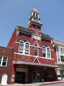
Former fire hall in the district in 2011 | |
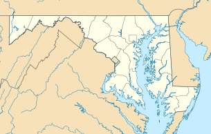 | |
| Location | Roughly bounded by Prospect and Canon Aves., Memorial Blvd. and the CSX RR tracks., Hagerstown, Maryland |
|---|---|
| Coordinates | 39°38′23″N 77°43′6″W / 39.63972°N 77.71833°WCoordinates: 39°38′23″N 77°43′6″W / 39.63972°N 77.71833°W |
| Built | 1770 |
| Architect | Sims and Sims |
| Architectural style | Italianate, Federal, Georgian Revival |
| Governing body | State |
| NRHP Reference # |
93001551 [1] |
| Added to NRHP | February 02, 1994 |
Hagerstown Historic District is a national historic district at Hagerstown, Washington County, Maryland, United States. The district contains the downtown commercial and governmental center as well as several surrounding urban residential neighborhoods and industrial areas. It includes the original plat of Hagerstown, laid out in the 1760s, as well as areas of expansion that developed generally prior to or just after the turn of the 20th century. Some 2,500 Confederate dead lie in Rose Hill Cemetery on South Potomac Street, most of whom died at the Battle of Antietam.[2]
It was added to the National Register of Historic Places in 1994.[1]
References
- ↑ 1.0 1.1 "National Register Information System". National Register of Historic Places. National Park Service. 2008-04-15.
- ↑ Maryland Historical Trust: Listing for Hagerstown Historic District
External links
![]() Media related to Hagerstown Historic District at Wikimedia Commons
Media related to Hagerstown Historic District at Wikimedia Commons
- Hagerstown Historic District, Washington County, including photo from 1991, at Maryland Historical Trust
- Boundary Map of the Hagerstown Historic District, Washington County, at Maryland Historical Trust
| |||||||||||||||||||||||||
