Hadrian's Wall
 | ||||
| Part of a series on the | ||||
| Military of ancient Rome | ||||
|---|---|---|---|---|
| Structural history | ||||
|
||||
| Campaign history | ||||
| Technological history | ||||
|
||||
| Political history | ||||
|
|
||||
| Strategy and tactics | ||||
|
||||
| Military of ancient Rome portal | ||||

Hadrian's Wall (Latin: Vallum Aelium), also called the Roman Wall, Picts' Wall, or Vallum Hadriani, was a defensive fortification in the Roman province of Britannia, begun in AD 122 during the rule of emperor Hadrian. It ran between the River Tyne and the Solway Firth. It had a stone base and a stone wall. There were milecastles with two turrets in between. There was a fort about every five miles. From north to south the wall comprised a ditch, wall, military way and vallum (another ditch with adjoining mounds). The milecastles had static garrisons, whereas the forts had fighting garrisons of infantry and cavalry. In addition to its military role, gates through the wall served as customs posts.[1]
A significant portion of the wall still exists and can be followed on foot along the Hadrian's Wall Path. It is the most popular tourist attraction in Northern England and was made a UNESCO World Heritage Site in 1987.[2]
Dimensions
Hadrian's Wall was 80 Roman miles or 117.5 km (73.0 mi) long;[3] its width and height varied according to the construction materials that were available nearby. East of the River Irthing, the wall was made from squared stone and measured 3 metres (9.8 feet) wide and 5 to 6 metres (16 to 20 feet) high, while west of the river the wall was originally made from turf and measured 6 metres (20 feet) wide and 3.5 metres (11 feet) high; it was later rebuilt in stone. These dimensions do not include the wall's ditches, berms and forts. The central section measured eight Roman feet wide (7.8 ft or 2.4 m) on a 3 m (10 ft) base. Some parts of this section of the wall survive to a height of 3 m (10 ft).
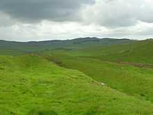
Immediately south of the wall, a large ditch was dug, with adjoining parallel mounds, one on either side. This is known today as the Vallum, even though the word Vallum in Latin is the origin of the English word wall, and does not refer to a ditch. In many places - for example Limestone Corner - the Vallum is better preserved than the wall, which has been much robbed of its stone.
Route


Hadrian's Wall extended west from Segedunum at Wallsend on the River Tyne, via Carlisle and Kirkandrews-on-Eden, to the shore of the Solway Firth, ending a short but unknown distance west of the village of Bowness-on-Solway.[4]
Although the curtain wall ends near Bowness-on-Solway, this does not mark the end of the line of defensive structures. The system of milecastles and turrets is known to have continued along the Cumbria coast as far as Risehow, south of Maryport.[5] For classification purposes, the milecastles west of Bowness-on-Solway are referred to as Milefortlets.
The A69 and B6318 roads follow the course of the wall from Newcastle upon Tyne to Carlisle, then along the northern coast of Cumbria (south shore of the Solway Firth). It is a common misconception that Hadrian's Wall marks the boundary between England and Scotland. In fact Hadrian's Wall lies entirely within England: while it is less than 1 kilometre (0.6 mi) south of the border with Scotland in the west at Bowness-on-Solway, in the east it is as much as 110 kilometres (68 mi) away.
Purpose of construction

Hadrian's Wall was probably planned before Hadrian's visit to Britain in AD 122. According to restored sandstone fragments found in Jarrow which date from 118 or 119, it was Hadrian's wish to keep "intact the empire", which had been imposed on him via "divine instruction".[6] The fragments then announce the building of the wall. It is entirely possible that, on his arrival in Britain in 122, one of the stops on his itinerary was the northern frontier to inspect the progress of the building of the wall.
Although Hadrian's biographer wrote "(Hadrian) was the first to build a wall 80 miles long to separate the Romans from the barbarians", reasons for the construction of the wall vary, and no recording of an exact explanation survives.[7] Theories have been presented by historians, mostly of an expression of Roman power and Hadrian's policy of defence before expansion. On his accession to the throne in 117, Hadrian had been experiencing rebellion in Roman Britain and from the peoples of various conquered lands across the Empire, including Egypt, Palestine, Libya and Mauretania.[6]
These troubles may have influenced Hadrian's plan to construct the wall as well as his construction of limites in other areas of the Empire, but to what extent is unknown. Scholars disagree over how much of a threat the inhabitants of northern Britain really presented and whether there was any economic advantage in defending and garrisoning a fixed line of defences like the Wall, rather than conquering and annexing what has become the Scottish Lowlands and defending the territory with a loose arrangement of forts.[6]
The limites of Rome were never expected to stop tribes from migrating or armies from invading, and while a frontier protected by a palisade or stone wall would help curb cattle-raiders and the incursions of other small groups,[8] the economic viability of constructing and keeping guarded a wall 72 miles (116 km) long along a sparsely populated border to stop small-scale raiding is dubious.[6]
Another possible explanation for the wall is the degree of control it would have provided over immigration, smuggling and customs.[6] Limites did not strictly mark the boundaries of the empire: Roman power and influence often extended beyond the walls.[6] People within and beyond the limes travelled through it each day when conducting business, and organised check-points like those offered by Hadrian's Wall provided good opportunities for taxation. With watch towers only a short distance from gateways in the limes, patrolling legionaries could have kept track of entering and exiting natives and Roman citizens alike, charging customs dues and checking for smuggling. Another theory is of a simpler variety—that Hadrian's Wall was partly constructed to reflect the power of Rome and was used as a political point by Hadrian. Once its construction was finished, it is thought to have been covered in plaster and then whitewashed: its shining surface reflected the sunlight and was visible for miles around.[6]
Construction
Construction started in AD 122[9] and was largely completed in six years.[10] Construction started in the east, between milecastles four and seven, and proceeded westwards, with soldiers from all three of the occupying Roman legions participating in the work. The route chosen largely paralleled the nearby Stanegate road from Luguvalium (Carlisle) to Coria (Corbridge), upon which were situated a series of forts, including Vindolanda. The wall in the east follows a hard, resistant igneous diabase rock escarpment, known as the Whin Sill.

The initial plan called for a ditch and wall with 80 small gated milecastle fortlets, one placed every Roman mile, holding a few dozen troops each, and pairs of evenly spaced intermediate turrets used for observation and signalling. However, very few milecastles are actually sited at exact Roman mile divisions: they can be up to 200 yards east or west because of landscape features or to improve signalling to the Stanegate forts to the south.[11] Local limestone was used in the construction, except for the section to the west of Irthing where turf was used instead, since there were no useful rock outcrops nearby. Milecastles in this area were also built from timber and earth rather than stone, but turrets were always made from stone. The Broad Wall was initially built with a clay-bonded rubble core and mortared dressed rubble facing stones, but this seems to have made it vulnerable to collapse, and repair with a mortared core was sometimes necessary.
The milecastles and turrets were of three different designs, depending on which Roman legion built them – inscriptions of the Second, Sixth, and Twentieth Legions, show that all were involved in the construction. They were about 493 metres (539 yards) apart and measured 14.02 square metres (150.9 square feet) internally.
Construction was divided into lengths of about 5 miles (8.0 km). One group of each legion would excavate the foundations and build the milecastles and turrets and then other cohorts would follow with the wall construction. The wall was finished in 128.
"Broad Wall" and "Narrow Wall"
Early in its construction, just after reaching the North Tyne, the width of the wall was narrowed to 2.5 metres (8.2 feet) or even less (sometimes 1.8 metres) (the "Narrow Wall"). However, Broad Wall foundations had already been laid as far as the River Irthing, where the Turf Wall began, demonstrating that construction worked from east to west. Many turrets and milecastles were optimistically provided with stub "wing walls" in preparation for joining to the Broad Wall, offering a handy reference for archaeologists trying to piece together the construction chronology.
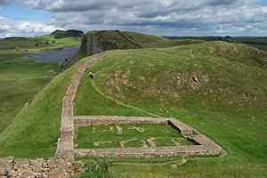
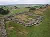
Within a few years it was decided to add a total of 14 to 17 (sources disagree) full-sized forts along the length of the wall, including Vercovicium (Housesteads) and Banna (Birdoswald), each holding between 500 and 1,000 auxiliary troops (no legions were posted to the wall). The eastern end of the wall was extended further east from Pons Aelius (Newcastle) to Segedunum (Wallsend) on the Tyne estuary. Some of the larger forts along the wall, such as Cilurnum (Chesters) and Vercovicium (Housesteads), were built on top of the footings of milecastles or turrets, showing the change of plan. An inscription mentioning early governor Aulus Platorius Nepos indicates that the change of plans took place early on. Also, some time during Hadrian's reign (before 138) the wall west of the Irthing was rebuilt in sandstone to about the same dimensions as the limestone section to the east.

After most of the forts had been added, the Vallum was built on the southern side. The wall was thus part of a defensive system which, from north to south, included:
- A row of forts built 5 to 10 miles (16 km) north of the wall, used for scouting and intelligence (e.g. Bewcastle Roman Fort)
- a glacis and a deep ditch
- a berm with rows of pits holding entanglements
- the curtain wall
- a later military road (the Military Way)
- The Vallum.

Turf wall
From Milecastle 49 to the western terminus of the wall at Bowness-on-Solway, the curtain wall was originally constructed from turf, possibly due to the absence of limestone for the manufacture of mortar.[12] Subsequently, the Turf Wall was demolished and replaced with a stone wall. This took place in two phases; the first (from the River Irthing to a point west of Milecastle 54), during the reign of Hadrian, and the second following the reoccupation of Hadrian's Wall subsequent to the abandonment of the Antonine Wall (though it has also been suggested that this second phase took place during the reign of Septimius Severus). The line of the new stone wall follows the line of the turf wall, apart from the stretch between Milecastle 49 and Milecastle 51, where the line of the stone wall is slightly further to the north.[12]
In the stretch around Milecastle 50TW, it was built on a flat base with three to four courses of turf blocks.[13] A basal layer of cobbles was used westwards from Milecastle 72 (at Burgh-by-Sands) and possibly at Milecastle 53.[14] Where the underlying ground was boggy, wooden piles were used.[12]
At its base, the wall was 6 metres (20 ft) wide, and built in courses of turf blocks measuring 18 inches (46 cm) long by 12 inches (30 cm) deep by 6 inches (15 cm) high, to a height estimated at around 3.66 metres (12.0 ft). The north face is thought to have had a slope of 75%, whereas the south face is thought to have started vertical above the foundation, quickly becoming much shallower.[12]
Standards
Above the curtain wall's foundations, one or more footing courses were laid. Offsets were introduced above these footing courses (on both the north and south faces), which reduced the wall's width. Where the width of the curtain wall is stated, it is in reference to the width above the offset. Two standards of offset have been identified. Standard A, where the offset occurs above the first footing course, and Standard B where the offset occurs after the third (or sometimes fourth) footing course.[15]

Garrison

According to the Vindolanda tablets, Roman soldiers stationed in AD 100 near the site of the wall were literate in Latin, wore underpants (subligaria), had wives who wrote each other birthday invitations, and called the locals by the derogatory term Brittunculi ('Little Britons'). The 752 tablets found so far (2010) are the oldest surviving handwritten documents in Britain. The wall was garrisoned by auxiliary (non-legionary) units of the army (non-citizens). Their numbers fluctuated throughout the occupation but may have been around 9,000 strong in general, including infantry and cavalry. The new forts could hold garrisons of 600 men (120 cavalry and 480 infantry for example as at Segedunum), while cavalry units of 1,000 troops were stationed at either end. The total number of soldiers manning the early wall probably exceeded 10,000. The garrison suffered serious attacks in 180, and especially between 190 and 197, when the garrison had been seriously weakened, following which major reconstruction had to be carried out under Septimius Severus. The region near the wall remained peaceful for most of the rest of the 3rd century. It is thought that some in the garrison may have married local women.
After Hadrian
In the years after Hadrian's death in 138, the new emperor, Antoninus Pius, essentially abandoned the wall, leaving it occupied in a support role, and began building a new wall called the Antonine Wall, about 160 kilometres (100 mi) north, in what later became known as the Scottish Lowlands, across the isthmus running west-south-west to east-north-east, sometimes referred to as the Central Belt or Central Lowlands. This turf wall ran 40 Roman miles, or about 37.8 mi (60.8 km), and had significantly more forts than Hadrian's Wall. Antoninus was unable to conquer the northern tribes, so when Marcus Aurelius became emperor, he abandoned the Antonine Wall and reoccupied Hadrian's Wall as the main defensive barrier in 164. In 208–211, the Emperor Septimius Severus again tried to conquer Caledonia and temporarily reoccupied the Antonine Wall. The campaign ended inconclusively and the Romans eventually withdrew to Hadrian's Wall. Bede describes the Antonine Wall (mistakenly ascribing its construction to Septimius Severus) thus in Historia Ecclesiastica 1.5:
After many great and dangerous battles, he [Septimius Severus] thought fit to divide that part of the island [the Scottish Lowlands], which he had recovered from the other unconquered nations, not with a wall, as some imagine, but with a rampart. For a wall is made of stones, but a rampart, with which camps are fortified to repel the assaults of enemies, is made of sods, cut out of the earth, and raised above the ground all round like a wall, having in front of it the ditch whence the sods were taken, and strong stakes of wood fixed upon its top. Thus Severus drew a great ditch and strong rampart, fortified with several towers, from sea to sea.
Following Gildas, the Venerable Bede further writes of the Antonine Wall:
But the islanders building the wall which they had been told to raise, not of stone, since they had no workmen capable of such a work, but of sods, made it of no use. Nevertheless, they carried it for many miles between the two bays or inlets of the sea of which we have spoken; to the end that where the protection of the water was wanting, they might use the rampart to defend their borders from the irruptions of the enemies. Of the work there erected, that is, of a rampart of great breadth and height, there are evident remains to be seen at this day [AD 730]. It begins at about two miles distance from the monastery of Aebbercurnig [Abercorn], west of it, at a place called in the Pictish language Peanfahel, but in the English tongue, Penneltun [Kinneil], and running westward, ends near the city of Aicluith [Dumbarton].
- Bede Historia Ecclesiastica Book I Chapter 12
Bede has clearly and not unreasonably, associated Gildas' turf wall with the Antonine Wall. As for Hadrian's Wall, Bede again follows Gildas:
[the departing Romans] thinking that it might be some help to the allies [Britons], whom they were forced to abandon, constructed a strong stone wall from sea to sea, in a straight line between the towns that had been there built for fear of the enemy, where Severus also had formerly built a rampart.
- Bede Historia Ecclesiastica Book I Chapter 12
Bede obviously identified Gildas' stone wall as Hadrian's Wall (actually built in the 120s) and he would appear to have deduced that the ditch-and-mound barrier known as the Vallum (just to the south of and contemporary with, Hadrian's Wall) was the rampart constructed by Severus. Many centuries would pass before just who built what became apparent.[16]
In the late 4th century, barbarian invasions, economic decline and military coups loosened the Empire's hold on Britain. By 410, the estimated End of Roman rule in Britain, the Roman administration and its legions were gone and Britain was left to look to its own defences and government. Archaeologists have revealed that some parts of the wall remained occupied well into the 5th century. Hadrian's Wall fell into ruin and over the centuries the stone was reused in other local buildings. Enough survived in the 8th century for spolia from Hadrian's Wall to find their way into the construction of Jarrow Priory.


The wall fascinated John Speed, who published a set of maps of England and Wales by county at the start of the 17th century. He described it as "the Picts Wall" (or "Pictes"; he uses both spellings). A map of Newecastle (sic), drawn in 1610 by William Matthew, described it as "Severus' Wall", mistakenly giving it the name ascribed by Bede to the Antonine Wall. The maps for Cumberland and Northumberland not only show the wall as a major feature, but are ornamented with drawings of Roman finds, together with, in the case of the Cumberland map, a cartouche in which he sets out a description of the wall itself.
Preservation by John Clayton
Much of the wall has disappeared. Long sections of it were used for roadbuilding in the 18th century,[17] especially by General Wade to build a military road (most of which lies beneath the present day B6318 "Military Road") to move troops to crush the Jacobite insurrection. The preservation of much of what remains can be credited to John Clayton. He trained as a lawyer and became town clerk of Newcastle in the 1830s. He became enthusiastic about preserving the wall after a visit to Chesters. To prevent farmers taking stones from the wall, he began buying some of the land on which the wall stood. In 1834, he started purchasing property around Steel Rigg. Eventually, he controlled land from Brunton to Cawfields. This stretch included the sites of Chesters, Carrawburgh, Housesteads, and Vindolanda. Clayton carried out excavation at the fort at Cilurnum and at Housesteads, and he excavated some milecastles.
Clayton managed the farms he had acquired and succeeded in improving both the land and the livestock. His successful management produced a cash flow, which could be invested in future restoration work. Workmen were employed to restore sections of the wall, generally up to a height of seven courses. The best example of the Clayton Wall is at Housesteads. After Clayton's death, the estate passed to relatives and was soon lost at gambling. Eventually, the National Trust began acquiring the land on which the wall stands. At Wallington Hall, near Morpeth, there is a painting by William Bell Scott, which shows a centurion supervising the building of the wall. The centurion has been given the face of John Clayton.
World Heritage Site
Hadrian's Wall was declared a World Heritage Site in 1987, and in 2005 it became part of the transnational "Frontiers of the Roman Empire" World Heritage Site which also includes sites in Germany.[18]
Tourism
Although Hadrian's Wall was declared a World Heritage Site in 1987, it remains unguarded, enabling visitors to climb and stand on the wall, although this is not encouraged, as it could damage the historic structure. On 13 March 2010, a public event Illuminating Hadrian's Wall took place, which saw the route of the wall lit with 500 beacons. On 31 August and 2 September 2012, there was a second illumination of the wall as a digital art installation called "Connecting Light", which was part of London 2012 Festival.
Hadrian's Wall Path
In 2003, a National Trail footpath was opened that follows the line of the wall from Wallsend to Bowness-on-Solway.[19] Because of the fragile landscape, walkers are asked to follow the path only in summer.[20]
Roman-period names


The only ancient source for its provenance is the Augustan History. No sources survive to confirm what the wall was called in antiquity, and no historical literary source gives it a name. However, the discovery of the Staffordshire Moorlands Pan in Staffordshire in 2003 has provided a clue. This small enamelled bronze Roman trulla (ladle), dating to the 2nd century AD, is inscribed with a series of names of Roman forts along the western sector of the wall, together with a personal name and the phrase MAIS COGGABATA VXELODVNVM CAMBOGLANNA RIGORE VALI AELI DRACONIS.
Bowness (MAIS) is followed by Drumburgh-by-Sands (COGGABATA) until now known only as CONGAVATA from the late Roman document, the Notitia Dignitatum. Next comes Stanwix (VXELODVNVM), then Castlesteads (CAMBOGLANNA).
RIGORE is the ablative singular form of the Latin word rigor. This can mean several things, but one of its less-known meanings is "straight line", "course", or "direction". This sense was used by Roman surveyors and appears on several inscriptions to indicate a line between places. So the meaning could be "according to the course".
There is no known word vali, but vallum was the Latin word for an earthen wall, rampart, or fortification;[22] today vallum is applied to the ditch and berm dug by the Roman army just south of the wall. The genitive singular form of vallum is valli, so one of the most likely meanings is VAL[L]I, "of the vallum". Omitting one of a pair of double consonants is common on Roman inscriptions; moreover, an error in the transcription of a written note could be the reason: another similar bronze vessel, known as the Rudge Cup (found in Wiltshire in the 18th century) has VN missing from the name VXELODVNVM, for example, although the letters appear on the Staffordshire Moorlands Pan. The Rudge Cup only bears fort names.
The name AELI was Hadrian's nomen, his main family name, the gens Aelia. The Roman bridge at Newcastle upon Tyne was called Pons Aelius.
DRACONIS can be translated as "[by the hand – or property] of Draco". It was normal for Roman manufacturers to give their names in the genitive ("of"), and "by the hand" would be understood. The form is common, for example, on Samian ware.
The translation, therefore, could be:
Mais, Coggabata, Uxelodunum, Camboglanna, according to the line of the Aelian wall. [By the hand or The property] of Draco.
Another possibility is that the individual's name was Aelius Draco, which would only leave us with an unspecified vallum, "wall".
Forts
The Latin and Romano-Celtic names of some of the Hadrian's Wall forts are known, from the Notitia Dignitatum and other evidence:
- Segedunum (Wallsend)
- Pons Aelius (Newcastle upon Tyne)
- Condercum (Benwell Hill)
- Vindobala (Rudchester)[23]
- Hunnum (Halton Chesters)[23]
- Cilurnum (Chesters aka Walwick Chesters)[23]
- Procolita (Carrowburgh)
- Vercovicium (Housesteads)
- Aesica (Great Chesters)[23]
- Magnis (Carvoran)
- Banna (Birdoswald)
- Camboglanna (Castlesteads)
- Uxelodunum (Stanwix. Also known as Petriana)
- Aballava (Burgh-by-Sands)
- Coggabata (Drumburgh)
- Mais (Bowness-on-Solway)
Turrets on the wall include:
Outpost forts beyond the wall include:
- Habitancum (Risingham)
- Bremenium (Rochester)[23]
- Fanum Cocidi (Bewcastle) (north of Birdoswald)
- Ad Fines (Chew Green)[24]
Supply forts behind the wall include:
- Alauna (Maryport)
- Arbeia (South Shields)
- Coria (Corbridge)
- Vindolanda (Little Chesters or Chesterholm)[23]
- Vindomora (Ebchester)[23]
In popular culture
- Nobel Prize–winning English author Rudyard Kipling contributed to the popular image of the "Great Pict Wall" in his short stories about Parnesius, a Roman legionary who defended the Wall against the Picts. These stories are a part of the Puck of Pook's Hill cycle, published in 1906.
- Hal Foster (1892–1982), a Canadian-American illustrator, used the wall in his comic strip Prince Valiant.
- Hadrian's Wall features in the work of British children's author Rosemary Sutcliff, in particular The Eagle of the Ninth and the collected short stories The Capricorn Bracelet.
- American author George R. R. Martin has acknowledged that Hadrian's Wall was the inspiration for The Wall in his best-selling series A Song of Ice and Fire, dramatised in the fantasy TV series Game of Thrones.[25]
- The wall has also been featured in recent films such as Centurion and The Eagle, and was a major focal point of the 2004 King Arthur in which one of the primary gates is opened for the first time since the wall's construction to allow Arthur and his knights passage into the north for their quest. The climactic Battle of Badon between the Britons led by Arthur and his knights, and the Saxons led by Cerdic and his son Cynric took place in the film just inside the wall. The wall was featured in Season 8, episode 8, of the History Channel's Modern Marvels in 2001.
- The soundtrack of the movie King Arthur by Hans Zimmer features a track titled "Another Brick in Hadrian's Wall", as a nod to Pink Floyd's composition "Another Brick in the Wall".
- In the film Robin Hood, Prince of Thieves, Robin Hood first meets Guy of Gisborne whilst walking with Azeem the wall at Sycamore Gap.
- In Blackadder: Back and Forth, the modern day Blackadder and Baldrick arrive in Roman Britain sometime around the Roman Empire's withdrawal from Britain in the 5th Century at Hadrian's Wall. Blackadder's Roman ancestor openly criticises Hadrian's attempt to keep out the Scots by "building a three-foot high wall"; the wall was said to be between 13 ft and 15 ft high.
- Black Country Communion have dedicated a song to a "Battle for Hadrian's Wall" on their album 2.
- The opening track from Maxim's first solo effort Hell's Kitchen is named "Hadrian's Wall".[26]
- Hadrian's Wall is the name of a Barrier ICE card in the card game Android: Netrunner.[27]
- The 2008 science fiction film Doomsday featured Hadrian's wall rebuilt to quarantine Scotland because of a deadly virus.
See also
References
- ↑ "obituary:Brian Dobson". Daily Telegraph. 21 September 2012. Retrieved 22 September 2012.
- ↑ English Heritage
- ↑ "BBC – History – Hadrian's Wall Gallery". Bbc.co.uk. 1 January 2013. Retrieved 26 March 2013.
- ↑ Breeze, David J (November 2006). Handbook to the Roman Wall (14th Revised ed.). Society of Antiquaries of Newcastle upon Tyne. ISBN 0-901082-65-1. Check date values in:
|year= / |date= mismatch(help) - ↑ Breeze, D.J. (2004). "Roman military sites on the Cumbrian coast". In R.J.A. Wilson and I.D Caruana, eds. Romans on the Solway : essays in honour of Richard Bellhouse. CWAAS Extra Series, vol.31. Kendal: Cumberland and Westmorland Antiquarian & Archaeological Society on behalf of the Trustees of the Senhouse Roman Museum, Maryport. pp. 1–231, p.66–94. ISBN 1873124392.
- ↑ 6.0 6.1 6.2 6.3 6.4 6.5 6.6 Anthony Everitt, Hadrian and the Triumph of Rome (2009), Random House, Inc, 448 pages; ISBN 0-8129-7814-5.
- ↑ Unknown. "11.2". Scriptores Historiae Augustae. Vita Hadriani.
- ↑ Stephen Johnson (2004) Hadrian's Wall, Sterling Publishing Company, Inc, 128 pages, ISBN 0-7134-8840-9
- ↑ Breeze, D.J., and Dobson, B., 2000, Hadrian's Wall (fourth edition), London: Penguin Books, pp86
- ↑ Wilson, 271.
- ↑ Woolliscroft, D., 1989, "Signalling and the design of Hadrian's Wall", Archaeologia Aeliana 5th Series, Vol. XVII, pp. 5–20.
- ↑ 12.0 12.1 12.2 12.3 Breeze, David J (November 2006). Handbook to the Roman Wall (14th Revised ed.). Society of Antiquaries of Newcastle upon Tyne. pp. 55–62. ISBN 0-901082-65-1. Check date values in:
|year= / |date= mismatch(help) - ↑ Simpson, F G; Richmond, I A; St Joseph, K (1935), "Report of the Cumberland Excavation Committee for 1934", Transactions of the Cumberland & Westmorland Antiquarian & Archaeological Society, new series (Titus Wilson & Son) 35: 220–32
- ↑ Simpson, F G; MacIntyre, J (1933), "Report of the Cumberland Excavation Committee for 1932", Transactions of the Cumberland & Westmorland Antiquarian & Archaeological Society, new series (Titus Wilson & Son) 33: 262–70
- ↑ Breeze, David J (1934), Handbook to the Roman Wall (14th Revised edition – November 2006), Society of Antiquaries of Newcastle upon Tyne, p. 53, ISBN 0-901082-65-1
- ↑ , From Dot to Domesday website
- ↑ Hadrian's Wall, English Lakes website
- ↑ UNESCO World Heritage Centre. "Frontiers of the Roman Empire". Retrieved 26 November 2007.
- ↑ "Hadrian's Wall Path". National Trails. Retrieved 26 November 2007.
- ↑ "Every Footstep Counts – The Trail's Country Code". Hadrians Wall Path National Trail. Retrieved 26 November 2007.
- ↑ Sycamore Gap, a section of the wall between two crests just east of Milecastle 39, is locally known as the "Robin Hood Tree" for its use in the 1991 film Robin Hood: Prince of Thieves (1991).
- ↑ Lewis and Short, A Latin Dictionary
- ↑ 23.0 23.1 23.2 23.3 23.4 23.5 23.6 Note the suffix "chester", reflecting the presence of a Roman castra.
- ↑ "GENUKI: The National Gazetteer of Great Britain and Ireland (1868) – Northumberland". Genuki.bpears.org.uk. 3 August 2010. Retrieved 26 March 2013.
- ↑ Martin, George R.R. "A Conversation With George R.R. Martin". The SF Site. Retrieved 10 September 2011.
- ↑ http://www.nekozine.co.uk/maxim/hellskitchen/hellskitchen.html
- ↑ "cardgamedb.com". Retrieved 10 July 2014.
Further reading
- Burton, Anthony Hadrian's Wall Path. 2004 Aurum Press Ltd. ISBN 1-85410-893-X.
- Davies, Hunter A Walk along the Wall, 1974 Wiedenfield and Nicolson: London ISBN 0 297 76710 0.
- de la Bédoyère, Guy. Hadrian's Wall: A History and Guide. Stroud: Tempus, 1998. ISBN 0-7524-1407-0.
- England's Roman Frontier: Discovering Carlisle and Hadrian's Wall Country. Hadrian's Wall Heritage Ltd and Carlisle Tourism Partnership. 2010.
- Forde-Johnston, James L. Hadrian's Wall. London: Michael Joseph, 1978. ISBN 0-7181-1652-6.
- Hadrian's Wall Path (map). Harvey, 12–22 Main Street, Doune, Perthshire FK16 6BJ. harveymaps.co.uk
- Speed Maps – A set of Speed's maps were issued bound in a single volume in 1988 in association with the British Library and with an introduction by Nigel Nicolson as 'The Counties of Britain A Tudor Atlas by John Speed'.
- Moffat, Alistair, The Wall. 2008 Birlinn Limited Press. ISBN 1-84158-675-7.
- Tomlin, R. S. O., "Inscriptions" in Britannia (2004), vol. xxxv, pp. 344–5 (the Staffordshire Moorlands cup naming the Wall).
- Wilson, Roger J.A., A Guide to the Roman Remains in Britain. London: Constable & Company, 1980. ISBN 0-09-463260-X.
- Charlotte Higgins (2014). Under Another Sky Chapter 7. London: Vintage. ISBN 978-0-099552-09-3.
External links
| Wikimedia Commons has media related to Hadrian's Wall. |
| Wikivoyage has a travel guide for Hadrian's Wall. |
- Hadrian's Wall on the Official Northumberland Visitor website
- Hadrian's Wall Discussion Forum
- UNESCO Frontiers of the Roman Empire
- News on the Wall path
- English Lakes article
- iRomans—website with interactive map of Cumbrian section of Hadrian Wall
- Connecting Light—art installation
| ||||||||||||||||||||
| ||||||||||||||||||||||||

| ||||||||||||||||||