HG postcode area
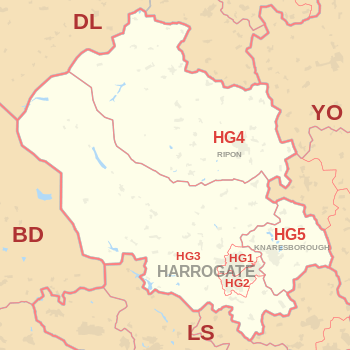
Postcode district boundaries: Bing
| Harrogate postcode area | |
 HG |
|
| Postcode area | HG |
|---|---|
| Postcode area name | Harrogate |
| Post towns | 3 |
| Postcode districts | 5 |
| Postcode sectors | 25 |
| Postcodes (live) | 4,446 |
| Postcodes (total) | 6,056 |
| Statistics as at February 2012[1] | |
The HG postcode area, also known as the Harrogate postcode area,[2] is a group of five postcode districts in England, which are subdivisions of three post towns. These postcode districts cover Harrogate, Ripon and Knaresborough in North Yorkshire.
HG1 and HG2 cover most of Harrogate; HG1 covering areas north of The Stray while HG2 covers areas to the south. HG3 spans across some of the western suburbs, while HG4 and HG5 cover the remainder of the borough.
Coverage
The approximate coverage of the postcode districts:
| Postcode district | Post town | Coverage | Local authority area |
|---|---|---|---|
| HG1 | HARROGATE | Central, Bilton, Jennyfields, Duchy, New Park | Harrogate |
| HG2 | HARROGATE | Oatlands, Woodlands, Hookstone, Rossett, Pannal Ash, Harlow Hill, Hornbeam Park | Harrogate |
| HG3 | HARROGATE | Pannal, Killinghall, Spofforth, Bishop Monkton, Glasshouses, Follifoot, Pateley Bridge | Harrogate |
| HG4 | RIPON | Ripon, North Stainley, High Grantley, Masham | Harrogate |
| HG5 | KNARESBOROUGH | Scotton, Knaresborough | Harrogate |
Map
See also
References
- ↑ "ONS Postcode Directory Version Notes" (ZIP). National Statistics Postcode Products. Office for National Statistics. February 2012. Table 2. Retrieved 21 April 2012. Coordinates from mean of unit postcode points, "Code-Point Open". OS OpenData. Ordnance Survey. February 2012. Retrieved 21 April 2012.
- ↑ Royal Mail, Address Management Guide, (2004)
| ||||||||||
