Höllentalbahn (Black Forest)
| Höllentalbahn Hell Valley Railway | |||
|---|---|---|---|
 | |||
| Technical | |||
| Line length | 74.7 km (46.4 mi) | ||
| Track gauge | 1,435 mm (4 ft 8 1⁄2 in) | ||
| Electrification |
1936 until 1960, 20 kV, 50 Hz, AC since 1960, 15 kV, 16⅔ Hz, AC | ||
| Operating speed | 100 km/h | ||
| Highest elevation | 607 m (1,991 ft) | ||
| Maximum incline | 5.5% | ||
| Rack system | 1887 until 1933; now adhesion | ||
| |||
| Stations, junctions and heights above sea level | |||||||||||||||||||||||||||||||||||||||||||||||||||||||||||||||||||||||||||||||||||||||||||||||||||||||||||||||||||||||||||||||||||||||||||||||||||||||||||||||||||||||||||||||||||||||||||||||||||||||||||||||||||||||||||||||||||||||||||||||||||||||||||||||||||||||||||||||||||||
|---|---|---|---|---|---|---|---|---|---|---|---|---|---|---|---|---|---|---|---|---|---|---|---|---|---|---|---|---|---|---|---|---|---|---|---|---|---|---|---|---|---|---|---|---|---|---|---|---|---|---|---|---|---|---|---|---|---|---|---|---|---|---|---|---|---|---|---|---|---|---|---|---|---|---|---|---|---|---|---|---|---|---|---|---|---|---|---|---|---|---|---|---|---|---|---|---|---|---|---|---|---|---|---|---|---|---|---|---|---|---|---|---|---|---|---|---|---|---|---|---|---|---|---|---|---|---|---|---|---|---|---|---|---|---|---|---|---|---|---|---|---|---|---|---|---|---|---|---|---|---|---|---|---|---|---|---|---|---|---|---|---|---|---|---|---|---|---|---|---|---|---|---|---|---|---|---|---|---|---|---|---|---|---|---|---|---|---|---|---|---|---|---|---|---|---|---|---|---|---|---|---|---|---|---|---|---|---|---|---|---|---|---|---|---|---|---|---|---|---|---|---|---|---|---|---|---|---|---|---|---|---|---|---|---|---|---|---|---|---|---|---|---|---|---|---|---|---|---|---|---|---|---|---|---|---|---|---|---|---|---|---|---|---|---|---|---|---|---|---|---|---|---|---|---|---|---|---|
Legend
| |||||||||||||||||||||||||||||||||||||||||||||||||||||||||||||||||||||||||||||||||||||||||||||||||||||||||||||||||||||||||||||||||||||||||||||||||||||||||||||||||||||||||||||||||||||||||||||||||||||||||||||||||||||||||||||||||||||||||||||||||||||||||||||||||||||||||||||||||||||
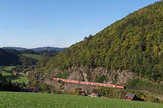
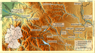
The Höllentalbahn (literally, "Hell Valley Railway") is a railway line that partially runs through the Höllental valley in the Black Forest of Germany. The line connects Freiburg im Breisgau with Donaueschingen, a distance of 74.7 km (46.4 mi).[1]
Over its entire course the line rises from an altitude of 278 m (912 ft) in Freiburg to 885 m (2,904 ft) in Hinterzarten. Part of the route has a 5.5% gradient, making the line one of the steepest in Germany. The line passes through beautiful scenery along its entire length.
History
The line, which opened as far as Neustadt in 1887, was constructed for the Grand Duchy of Baden State Railways and was the last project of railway architect Robert Gerwig. The 7.2 km (4.5 mi) section of the line between Hirschsprung and Hinterzarten has a maximum gradient of 5.5%, and was initially operated as a rack railway on the Riggenbach system.[1]
The line was extended from Neustadt to Donaueschingen in 1901. In 1932/33, ten powerful Class 85 steam locomotives were built, which enabled traffic to operate over the Hirschsprung and Hinterzarten section without rack assistance, and rack operation ceased in 1933.
In 1934, a new and partially tunnelled route within the city of Freiburg was opened. This enabled the original route, which passed closer to the city centre and over congested level crossings, to be closed.[2]
In 1936, the Deutsche Reichsbahn electrified the line between Freiburg and Neustadt, installing a 20 kV, 50 Hz AC. This led to the subsequent adoption of the 25 kV AC 50 Hz system in France and elsewhere. Since the eletrification of Mannheim–Karlsruhe–Basle railway had been completed in 1958, the Höllentalbahn was linked to the nationwide electric railway system. Therefore, in 1960, the electrified section of the Höllentalbahn was converted to the standard 15 kV, 16⅔ Hz system used throughout the German railway network.
The Höllentalbahn was used successfully to test designs for the DB Class 144. Later, electric motive power was supplied by the Series 145, which was itself replaced by the DB Class 139. Today, the electric line uses modern double-decker rolling stock pulled by DB Class 143 locomotives.
The stretch of line between Neustadt and Donaueschingen remains unelectrified.[1]
Route
After leaving Freiburg Hauptbahnhof, the main station for the city of Freiburg, the Höllentalbahn diverges from the mainline Mannheim–Karlsruhe–Basel railway to the east. It the crosses over the mainline on a flyover and serves two further stops within the city, before starting its ascent of the Höllental.[1]
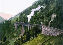
High points on the stretch of the line through the Höllental include the Hirschsprungfelsen (a rock formation) and a crossing of the Ravenna Gorge on the 40-metre (131 ft) high Ravenna Bridge. The section of the line between Hirschsprung and Hinterzarten has a steep maximum gradient of 5.5%, betraying its origin as a rack railway.[1]
After leaving the Höllental, the Dreiseenbahn railway to Seebrugg diverges at the spa town of Titisee, close to the Titisee lake. The town of Neustadt follows, where electrification ends and through passengers normally need to change trains.[1]
Further on, between Neustadt and Donaueschingen, the viaduct at the former Kappel Gutachbrücke station crosses the Wutach at the beginning of its long gorge. While in a 535-metre (1,755 ft) tunnel near Döggingen station, the line crosses a main European watershed, between the Rhine drainage basin (flowing into the North Sea) and the Danube drainage basin (flowing into the Black Sea).
References
Gallery
-

The Höllentalbahn around 1900
-
Ravenna Bridge
-

Ravenna Bridge
-

Gutach Bridge
-

Electric and diesel trains meet at Neustadt
-

DRG/DB Class 85 engine
-

Construction of the track
-

Old ravenna bridge
-
.jpg)
Old level-crossing house
-

Freiburg (Breisgau) main station
-

Freiburg Littenweiler halt
-

Himmelreich station
-

Beginning of the Hell Valley
-

Hinterzarten station
-

Train near Löffingen station
External links
 Media related to Höllentalbahn (Schwarzwald) at Wikimedia Commons
- Locomotive DB 85 as a 1:85 model

