Höchstadt
| Höchstadt | ||
|---|---|---|
| ||
 Höchstadt | ||
Location of Höchstadt within Erlangen-Höchstadt district 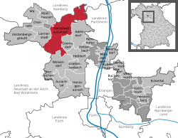 | ||
| Coordinates: 49°42′N 10°48′E / 49.700°N 10.800°ECoordinates: 49°42′N 10°48′E / 49.700°N 10.800°E | ||
| Country | Germany | |
| State | Bavaria | |
| Admin. region | Middle Franconia | |
| District | Erlangen-Höchstadt | |
| Government | ||
| • Mayor | Gerald Brehm ("Junge Liste Höchstadt und Umgebung e.V.") | |
| Area | ||
| • Total | 70.90 km2 (27.37 sq mi) | |
| Population (2013-12-31)[1] | ||
| • Total | 13,162 | |
| • Density | 190/km2 (480/sq mi) | |
| Time zone | CET/CEST (UTC+1/+2) | |
| Postal codes | 91315 | |
| Dialling codes | 09193 | |
| Vehicle registration | ERH | |
| Website | www.hoechstadt.de | |

Höchstadt an der Aisch, commonly known as Höchstadt, is a town in the Erlangen-Höchstadt district, in Bavaria, Germany.
Geography
Höchstadt is situated on the river Aisch, 18 km northwest of Erlangen and 22 km south of Bamberg. Originally it was the capital of the Höchstadt district, but then it became part of the new Erlangen-Höchstadt district.
Division of the town
The town consists of 23 districts:
|
|
|
Leisure
Food
Carp is a very important food, but only in the months with an "r" (September, October, November, December, January, February, March, April). There are various carp dishes: e.g., "blue carp", "baked carp" and "pepper carp". Carp eaten there is termed "Aischgründer Karpfen".
Culture
There is an events centre (converted from a former shoe factory) that includes a music school and a library; there is an evening event most days.
References
- ↑ "Fortschreibung des Bevölkerungsstandes". Bayerisches Landesamt für Statistik und Datenverarbeitung (in German). 31 December 2013.
External links
- Official site (German)
- Webcam of a storks' nest
| ||||||||